Lapal Tunnel
| Overview | |
|---|---|
| Location | West Midlands, England |
| Coordinates | 52°26′42″N 2°00′06″W / 52.4450°N 2.0017°WCoordinates: 52°26′42″N 2°00′06″W / 52.4450°N 2.0017°W |
| OS grid reference | SO998830 |
| Status | Closed |
| Waterway | Dudley No. 2 Canal |
| Start | 52°26′45″N 2°01′39″W / 52.4458°N 2.0275°W |
| End | 52°26′39″N 1°58′33″W / 52.4442°N 1.9759°W |
| Operation | |
| Constructed | 1798 |
| Closed | 1917 |
| Technical | |
| Design engineer | William Underhill |
| Length | 3,470-metre (11,385 ft) |
| Tunnel clearance | 6 feet (1.8 m) |
| Width | 7 feet 3 inches (2.2 m) |
| Towpath | no |
| Boat-passable | no |
The Lapal Tunnel (old spelling Lappal Tunnel) is a disused 3,470-metre (11,385 ft) canal tunnel on the five mile dry section of the Dudley No. 2 Canal in the West Midlands, England. It takes its name from the settlement of Lapal.
The narrow brick-lined tunnel, built in 1798 by William Underhill, had no towpath. It had a very small bore - at 7 feet 9 inches, barely wider than the boats which used it, with a headroom of only 6 feet. Boats originally took about three hours to complete the passage by legging or poling, so in 1841 a steam engine was built at the Halesowen end which drove a scoop wheel to load the tunnel with water. Stop gates could be opened at either end to assist boats along the tunnel in either direction.
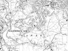
The tunnel suffered many collapses, and after a collapse in 1917 due to mining subsidence it was abandoned. It runs under Lapal, the M5 motorway near junction 3 and Woodgate Valley Country Park. The canal on the south side of the tunnel is also disused and some sections have been filled in as the tunnel was considered uneconomic to repair. To the north of the tunnel, the canal is in good repair and is used by boats accessing Hawne basin.
Restoration
The Lapal Canal Trust is concerned with restoring the lost canal to make it navigable up to the tunnel from both the Halesowen and Selly Oak ends, and originally had a longer term aim of restoring the tunnel. In May 2007 the trust received recommendations from professional consultants, Atkins, that the tunnel should not be restored but replaced by a new up-and-over alignment instead.
In February 2012 plans for the regeneration of the Selly Oak area were submitted to Birmingham City Council which included a navigable section of canal from a new junction with the Worcester and Birmingham Canal to the recently reconstructed Harborne Lane bridge.[1][2]
Points of interest
| Point | Coordinates (Links to map resources) |
OS Grid Ref | Notes |
|---|---|---|---|
| End of navigable Dudley No 2 Canal | 52°27′23″N 2°02′29″W / 52.4565°N 2.0415°W | SO9718084325 | near Halesowen |
| West portal | 52°26′45″N 2°01′39″W / 52.4458°N 2.0275°W | SO98228309 | (precise OS ref from 6" map) At western end of track opposite Lapal Cottage, Lapal Lane South |
| Mid point | 52°26′42″N 2°00′06″W / 52.4450°N 2.0017°W | SP9996583000 | (calculated) |
| East portal | 52°26′39″N 1°58′33″W / 52.4442°N 1.9759°W | SP01718291 | (precise OS ref from 6" map) Buried under grass slope |
| Harborne Lane bridge | 52°26′37″N 1°56′33″W / 52.4435°N 1.9426°W | SP03908288 | |
| Selly Oak Junction | 52°26′37″N 1°56′16″W / 52.4436°N 1.9377°W | SP0423482891 | Terminus of canal at Selly Oak |
See also
References
- ↑ "Revised Regeneration Plans for Selly Oak". Selly Oak Regeneration. Retrieved 6 May 2012.
- ↑ "The Selly Oak Restoration and Regeneration". Lapal Canal Trust. Retrieved 6 May 2012.
- Birmingham's Canals, Ray Shill, 1999, 2002, ISBN 0-7509-2077-7
- Lapal Canal Trust – Restoration of the Dudley No. 2 Canal between Halesowen and Selly Oak
- Lapal Canal Trust - History of No 2 canal
- British Waterways map of Dudley No. 2 Canal
- Nicholson waterways Guide 2 - Severn, Avon and Birmingham, Collins, 2006 ISBN 978-0-00-721110-4