Langlade County Airport
| Langlade County Airport | |||||||||||||||
|---|---|---|---|---|---|---|---|---|---|---|---|---|---|---|---|
|
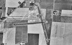
1998 USGS Photo | |||||||||||||||
| IATA: none – ICAO: KAIG – FAA LID: AIG | |||||||||||||||
| Summary | |||||||||||||||
| Airport type | Public | ||||||||||||||
| Owner/Operator | Langlade County | ||||||||||||||
| Location | Town of Antigo, Wisconsin | ||||||||||||||
| Elevation AMSL | 1,521 ft / 464 m | ||||||||||||||
| Coordinates | 45°09′15″N 089°06′39″W / 45.15417°N 89.11083°W | ||||||||||||||
| Map | |||||||||||||||
 AIG  AIG Location of airport in Wisconsin/United States | |||||||||||||||
| Runways | |||||||||||||||
| |||||||||||||||
| Statistics | |||||||||||||||
| |||||||||||||||
Langlade County Airport (ICAO: KAIG, FAA LID: AIG) is a county owned public use airport located two nautical miles (4 km) northeast of the central business district of Antigo, a city in Langlade County, Wisconsin, United States. It is included in the Federal Aviation Administration (FAA) National Plan of Integrated Airport Systems for 2017–2021, in which it is categorized as a basic general aviation facility.[2]
Although most U.S. airports use the same three-letter location identifier for the FAA and IATA, this airport is assigned AIG by the FAA but has no designation from the IATA[3] (which assigned AIG to Yalinga in the Central African Republic[4]).
History
The facility was used by the United States Army Air Forces as a contract glider training airfield. Known as Antigo Airport. Anderson Air Activities provided preliminary glider training. The school was one of 18 private operator contract schools that ran for 90 days beginning approximately July 6, 1942. There were but a few two place soaring gliders available for training. The Army delivered a few single engine, L type aircraft to be used. The primary training in these aircraft involved so called "dead-stick" landings. The student and instructor flew to various prescribed altitudes up to 5,000 feet (1,500 m) and the engine was shut off. The student then landed the plane as a glider.
By September 1942 the Southeast Air Forces Training Command has been instructed to shut down the school as the shortage of gliders and single engine aircraft did not allow the school to train and produce the number of students required by the USAAF. Antigo was closed, the Army flew the planes out and the land was returned to the local farmers.
Facilities and aircraft
Langlade County Airport covers an area of 440 acres (180 ha) at an elevation of 1,521 feet (464 m) above mean sea level. It has two asphalt paved runways: 17/35 is 4,010 by 75 feet (1,220 x 23 m); 9/27 is 3,400 by 75 feet (1,036 x 23 m). Both runways have approved GPS approaches. The Antigo NDB navaid, (AIG) frequency 347 kHz, is located on the field.
For the 12-month period ending September 9, 2014, the airport had 8,250 aircraft operations, an average of 23 per day: roughly 97% general aviation, 2% air taxi and 1% military. In November 2016, there were 18 aircraft based at the airport: 13 single-engine and 5 ultra-light aircraft. [1]
Walker Aviation LLC is the Fixed-Base Operator.
In March 2008, the Governor of Wisconsin approved plans to construct a new T-hangar for nearly $400,000 with the Federal Aviation Administration providing the bulk of the funding.[5]
Incidents
- 2 people were killed December 9, 1993 when their Piper PA-32R-300 crashed while attempting to land during IFR weather conditions.[6]
See also
- List of airports in Wisconsin
- Wisconsin World War II Army Airfields
- 29th Flying Training Wing (World War II)
References
![]() This article incorporates public domain material from the Air Force Historical Research Agency website http://www.afhra.af.mil/.
This article incorporates public domain material from the Air Force Historical Research Agency website http://www.afhra.af.mil/.
| Wikimedia Commons has media related to Antigo Airport. |
- Shaw, Frederick J. (2004), Locating Air Force Base Sites History’s Legacy, Air Force History and Museums Program, United States Air Force, Washington DC, 2004.
- Manning, Thomas A. (2005), History of Air Education and Training Command, 1942–2002. Office of History and Research, Headquarters, AETC, Randolph AFB, Texas ASIN: B000NYX3PC
- 1 2 FAA Airport Master Record for AIG (Form 5010 PDF), effective Nov 10, 2016.
- ↑ "List of NPIAS Airports" (PDF). FAA.gov. Federal Aviation Administration. 21 October 2016. Retrieved 23 November 2016.
- ↑ Great Circle Mapper: KAIG - Langlade County Airport - Antigo, Wisconsin
- ↑ Great Circle Mapper: AIG / FEFY - Yalinga, Central African Republic
- ↑ Governor Doyle approves $391,729 project at Langlade County Airport. March 4, 2008.
- ↑ NTSB Identification: CHI94FA048. Accident occurred December 9, 1993 in Antigo, Wisconsin.
External links
- Airport page at Langlade County website
- Langlade County Airport at Wisconsin DOT Airport Directory
- The WW II Glider Pilots
- FAA Terminal Procedures for AIG, effective December 8, 2016
- Resources for this airport:
- FAA airport information for AIG
- AirNav airport information for AIG
- FlightAware airport information and live flight tracker
- SkyVector aeronautical chart for AIG
Aviation in Wisconsin | ||
|---|---|---|
| Primary airports | ||
| Airlines | ||
| Aviation related | ||
| People | ||
| Flying Training |
|  | ||||||
|---|---|---|---|---|---|---|---|---|
| Technical Training |
| |||||||