Langenfeld, Rhineland
| Langenfeld | ||
|---|---|---|
 | ||
| ||
 Langenfeld | ||
Location of Langenfeld within Mettmann district 
 | ||
| Coordinates: 51°7′N 6°57′E / 51.117°N 6.950°ECoordinates: 51°7′N 6°57′E / 51.117°N 6.950°E | ||
| Country | Germany | |
| State | North Rhine-Westphalia | |
| Admin. region | Düsseldorf | |
| District | Mettmann | |
| Government | ||
| • Mayor | Frank Schneider (CDU) | |
| Area | ||
| • Total | 41.10 km2 (15.87 sq mi) | |
| Population (2015-12-31)[1] | ||
| • Total | 58,033 | |
| • Density | 1,400/km2 (3,700/sq mi) | |
| Time zone | CET/CEST (UTC+1/+2) | |
| Postal codes | 40764 | |
| Dialling codes | 02173, (02171), (0212) | |
| Vehicle registration | ME | |
| Website | www.langenfeld.de | |

Langenfeld is a town in North-Rhine-Westphalia (Germany) in the district of Mettmann. The suburban city is located between Düsseldorf and Cologne. Langenfeld was formed from the two localities of Richrath and Reusrath and received city rights in 1948.
Economics
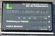

Langenfeld has no public debt as of October 3, 2008. The debt clock installed at the City Hall in 1997, showing the current debts of Langenfeld, the Rhineland, and the national debt, got demounted end of 2008 and handed over to Grevenbroich. In Langenfeld it had served its purpose, so the comment by former mayor Magnus Staehler. The town was honored for that with the prize Kommune des Jahres 2007 (Municipality of the Year 2007) in the national contest Großer Preis des Mittelstandes (Grand Prize by Small Firms and Traders) of the Oskar-Patzelt-Siftung.[2] To achieve that goal, on the one hand taxes got raised and in addition cuts of subsidies to clubs applied, so that debts halved from 1997 up to 2002.[3] Being free of debt, and with that regaining free hand, was celebrated with a big party for the citizens at the first weekend in October under the slogan "Golden Times".[4] Up to 2013 the savings from that surpluses had strongly diminished again by the budget deficits of the following years.[5]
Transportation
Langenfeld is accessed by nearby highways A 3, A 59 and A 542, as well as the Bundesstrasse (federal route) B8. The mainline railway from Düsseldorf to Cologne runs through the town's area as well. Public transport is provided by the S-Bahn line S6 and various bus lines operating under the umbrella of the VRR.
The nearest airports are Düsseldorf International (approx. 28 km) and Cologne Bonn Airport (approx. 35 km).
International relations
Langenfeld, Rhineland is twinned with:[6]
External links
- German Website of the City of Langenfeld (Rheinland)
-

Wikimedia Commons has media related to Langenfeld (Rheinland).
References
- ↑ "Amtliche Bevölkerungszahlen". Landesbetrieb Information und Technik NRW (in German). 18 July 2016.
- ↑ Langenfeld ist „Kommune des Jahres“: mittelstandspreis.com, Herbst 2007
- ↑ http://www.lebendige-stadt.de: Symposium „Stadt der Zukunft“ in der Autostadt Wolfsburg 27. September 2002.
- ↑ "Langenfeld: 2008: Endlich schuldenfrei!". 2 October 2008. Retrieved 3 October 2008.
- ↑ Langenfeld: Haushaltsentwurf 2013: CDU-Mehrheit stimmt zu. auf: rp-online.de, 6. März 2013.
- ↑ "Partnerstädte" (in German). Stadt Langenfeld. Retrieved 2015-01-04.
Towns and municipalities in Mettmann (district) | ||
|---|---|---|