Esslingen (district)
| Esslingen | |
|---|---|
| District | |
 | |
| Country |
|
| State | Baden-Württemberg |
| Adm. region | Stuttgart |
| Capital | Esslingen am Neckar |
| Area | |
| • Total | 641.49 km2 (247.68 sq mi) |
| Population (31 December 2015)[1] | |
| • Total | 524,127 |
| • Density | 820/km2 (2,100/sq mi) |
| Time zone | CET (UTC+1) |
| • Summer (DST) | CEST (UTC+2) |
| Vehicle registration | ES, NT |
| Website | http://www.landkreis-esslingen.de |
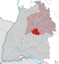
Esslingen is a district (Landkreis) in the centre of Baden-Württemberg, Germany. Neighboring districts are (from north clockwise) Rems-Murr, Göppingen, Reutlingen, Böblingen and the district-free city Stuttgart.
History
The district dates back to the Oberamt Esslingen, which was created when the previously free imperial city Esslingen became part of Württemberg in 1803. After several changes over the next century, it was converted into a district in 1938. Additionally, it was enlarged by adding several municipalities from the neighboring Amtsoberamt Stuttgart, Oberamt Schorndorf, Kirchheim unter Teck and Göppingen.
In 1973, the district was merged with the district Nürtingen (without Grafenberg). In 1975, two municipalities from the district Böblingen were added to give the district today's borders.
Geography
The district is cut into two halves by the river Neckar. The west part is part of the Filder plain, while the east is part of the mountains of the Swabian Alb (Schwäbische Alb).
Coat of arms
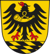 |
The coat of arms shows the imperial eagle taken from the coat of arms of the city of Esslingen. The checkered diamonds in the bottom are the symbol of the Dukes of Teck, and the horn on the breast of the eagle is the symbol of the Counts of Urach. Both symbols were taken from the coat of arms of the district of Nürtingen, as the two families played a major role in the history of the area. |
Cities and towns
| Cities | Administrative districts | Towns | |
|---|---|---|---|
|
References
External links
| Wikimedia Commons has media related to Landkreis Esslingen. |
- Official website (German)
- City Portal (German)
Coordinates: 48°41′N 9°19′E / 48.69°N 9.32°E