Lalleu
| Lalleu An Alloz | |
|---|---|
|
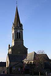
The church of Saint-Jean-Baptiste | |
 Lalleu | |
|
Location within Brittany region  Lalleu | |
| Coordinates: 47°51′22″N 1°30′32″W / 47.8561°N 1.5089°WCoordinates: 47°51′22″N 1°30′32″W / 47.8561°N 1.5089°W | |
| Country | France |
| Region | Brittany |
| Department | Ille-et-Vilaine |
| Arrondissement | Redon |
| Canton | Le Sel-de-Bretagne |
| Intercommunality | Moyenne Vilaine et du Semnon |
| Government | |
| • Mayor (2014–2020) | Marie-Christine Digue |
| Area1 | 15.47 km2 (5.97 sq mi) |
| Population (2008)2 | 565 |
| • Density | 37/km2 (95/sq mi) |
| Time zone | CET (UTC+1) |
| • Summer (DST) | CEST (UTC+2) |
| INSEE/Postal code | 35140 / 35320 |
| Elevation | 31–104 m (102–341 ft) |
|
1 French Land Register data, which excludes lakes, ponds, glaciers > 1 km² (0.386 sq mi or 247 acres) and river estuaries. 2 Population without double counting: residents of multiple communes (e.g., students and military personnel) only counted once. | |
Lalleu (Breton: An Alloz) is a commune in the Ille-et-Vilaine department in Brittany in northwestern France.
Geography
The stream de la Couyère forms all of the commune's eastern border, then flows into the Semnon, which forms all of its southern border.
Population
Inhabitants of Lalleu are called Allodiens in French.
| Historical population | ||
|---|---|---|
| Year | Pop. | ±% |
| 1962 | 497 | — |
| 1968 | 588 | +18.3% |
| 1975 | 506 | −13.9% |
| 1982 | 460 | −9.1% |
| 1990 | 445 | −3.3% |
| 1999 | 469 | +5.4% |
| 2008 | 565 | +20.5% |
See also
References
External links
| Wikimedia Commons has media related to Lalleu. |
This article is issued from Wikipedia - version of the 3/15/2016. The text is available under the Creative Commons Attribution/Share Alike but additional terms may apply for the media files.