Lake Winnipesaukee
| Lake Winnipesaukee | |
|---|---|
 Lake Winnipesaukee from summit of Mt. Major | |
 Lake Winnipesaukee | |
| Location | Belknap County and Carroll County, New Hampshire |
| Coordinates | 43°36′N 71°20′W / 43.600°N 71.333°WCoordinates: 43°36′N 71°20′W / 43.600°N 71.333°W |
| Primary inflows | Gunstock River; Merrymeeting River; Melvin River; Red Hill River |
| Primary outflows | Winnipesaukee River |
| Basin countries | United States |
| Max. length | 20.8 miles (33.4 km) |
| Max. width | 9.0 miles (14.5 km) |
| Surface area | 71 sq mi (180 km2) |
| Max. depth | 212 ft (65 m) |
| Shore length1 | 288 miles (463 km) |
| Surface elevation | 504 ft (154 m) |
| Islands | 258[1] |
| Settlements | see article |
| 1 Shore length is not a well-defined measure. | |
Lake Winnipesaukee (/ˌwɪnɪpəˈsɔːki/) is the largest lake in the U.S. state of New Hampshire, located in the Lakes Region. It is approximately 21 miles (34 km) long (northwest-southeast) and from 1 to 9 miles (1.6 to 14.5 km) wide (northeast-southwest), covering 69 square miles (179 km2)—71 square miles (184 km2) when Paugus Bay is included[2]—with a maximum depth of 212 feet (65 m). The center area of the lake is called The Broads.[3]:31
The lake contains at least 258 islands,[1] half of which are less than a quarter-acre in size, and is indented by several peninsulas, yielding a total shoreline of approximately 288 miles (463 km). The driving distance around the lake is 63 miles (101 km). It is 504 feet (154 m) above sea level. Winnipesaukee is the third-largest lake in New England after Lake Champlain and Moosehead Lake.
Outflow is regulated by the Lakeport Dam[4] in Lakeport, New Hampshire, on the Winnipesaukee River.
History


Lake Winnipesaukee has been a popular tourist destination for more than a century, particularly among residents seeking a safe haven from the summer heat of Boston and New York City. The Native American name Winnipesaukee (often spelled Winnipiseogee in earlier centuries[5]:27 [6]) means either "smile of the Great Spirit" or "beautiful water in a high place".[5]:19 At the outlet of the lake, the Winnipesaukee Indians, a subtribe of the Pennacook, lived and fished at a village called Acquadocton. Today, the site is called The Weirs, named for the weirs colonists discovered when first exploring the region.
Winnipesaukee is a glacial lake but an unusual one, since the last glaciation actually reversed the flow of its waters. Draining the central portion of New Hampshire, it once flowed southeast, leaving via what is now Alton Bay toward the Atlantic Ocean. When glacial debris blocked this path, flow was redirected westward through Paugus Bay into the Winnipesaukee River. The latter flows west from the lake and joins the Pemigewasset River in Franklin to form the Merrimack River, which flows south to Massachusetts and into the Atlantic.
Center Harbor witnessed the first intercollegiate sporting event in the United States, as Harvard defeated Yale by two lengths in the first Harvard–Yale Regatta on August 3, 1852.[7] The outcome was repeated 100 years later when the schools celebrated the centennial of the race by again competing on Lake Winnipesaukee (Harvard winning by 2.7 seconds).[8]
Lake Winnipesaukee was also where the eponymous Lake Winnipesaukee mystery stone was found.
Cities and towns
.jpg)
The communities that surround the lake, clockwise from the southernmost town, are:
- Alton, the largest town by area in the Lakes Region.
- Gilford, home to Gunstock Mountain Resort and Bank of New Hampshire Pavilion at Meadowbrook, a popular New Hampshire concert venue.
- Laconia, the main commercial city on the lake (surrounding Paugus Bay). Included in Laconia is Weirs Beach, the largest public bathing area on Winnipesaukee. Every year Laconia is home to Bike Week, attracting tens of thousands of motorcyclists to the area.
- Meredith, whose harbor lies on the northwestern reach of the lake.
- Center Harbor, a small town in Belknap County which serves as the winter home for the MS Mount Washington.
- Moultonborough, with its Castle in the Clouds, an estate atop a small mountain.
- Tuftonboro, which contains the communities of Melvin Village and Mirror Lake.
- Wolfeboro, which bills itself as the "oldest summer resort in America".
Divisions of the lake
The lake consists of a wide, relatively open central region known as The Broads, surrounded by several large bays, as well as many smaller inlets. The main sections of the lake are:
The Broads
The Broads are a wide portion of Lake Winnipesaukee largely in Belknap County and extending slightly into Carroll County.[9] It is a large island-free zone occupying the center of the lake.[3]:31 It was named after The Broads, in England.[10]
The daytime speed limit for boats on The Broads is 45 miles per hour (72 km/h).[11]
Running along the main axis of the lake, the northwestern tip of The Broads is at the town of Center Harbor, while the southeastern end lies between the towns of Alton and Wolfeboro.
Meredith Bay
Meredith Bay lies at the western edge of Winnipesaukee. At the northern tip of Meredith Bay is the main village of the town of Meredith. Paugus Bay branches off to the south of Meredith Bay at Weirs Beach, near to where Meredith Bay joins the main body of the lake. Meredith Bay is separated from The Broads by a relatively narrow strait bordered by Governors Island to the south and Stonedam Island to the north. The northeastern shore of Meredith Bay is a long peninsula known as Meredith Neck.
Paugus Bay
Formerly a hydrologically distinct lake, Paugus Bay became joined to Winnipesaukee when the dam at Lakeport was constructed, raising the surface of Paugus Bay to be contiguous with Winnipesaukee. Paugus Bay joins the main lake in Meredith Bay, running south from a narrow channel connecting it to Meredith Bay. At the northern end of Paugus Bay, where it joins the main lake, is Weirs Beach, the largest and most visited public beach on the lake. At the other end is the village of Lakeport. Both Weirs Beach and Lakeport are villages within the city of Laconia. The eastern shore of the bay is closely followed by U.S. Route 3, and has numerous motels, hotels, inns, and bungalow complexes. The western shore is much less developed.
Alton Bay
Alton Bay is a narrow bay which runs due south from the southern corner of the main lake. It lies entirely within the town of Alton. The village of Alton Bay lies at the extreme southern tip.
Wolfeboro Bay
Wolfeboro Bay is a relatively small wide bay lying in the town of Wolfeboro, creating a small northerly bulge in the shoreline to the eastern edge of Winnipesaukee. A series of smaller lakes and streams connects Wolfeboro Bay to Lake Wentworth.
Winter Harbor
Winter Harbor is a Y-shaped bay with two branches, separated from The Broads by Wolfeboro Neck and Tuftonboro Neck. Winter Harbor is surrounded by many quiet resort communities in the towns of Wolfeboro and Tuftonboro. A small stream connects Winter Harbor to Mirror Lake at the northern tip of the western branch.
Moultonborough Bay
The longest bay on Winnipesaukee is Moultonborough Bay. It is connected to The Broads by some narrow straits running between a cluster of islands including Long Island (the largest island in the lake), Cow Island, Little Bear Island, Sandy Island, and dozens of smaller islands and islets. The 7-mile-long (11 km) Moultonborough Neck separates the length of the bay from the main axis of the lake, and the Suissevale development in the town of Moultonborough is at the northern tip of the bay. Melvin Village, the main lakeside village of the town of Tuftonboro lies along the northeastern shore of the bay, closer to where it joins The Broads.
Islands

There are at least 258 natural islands on Lake Winnipesaukee that are at least 3 feet (0.9 m) above lake level and contain vegetation, about 130 of which are over .25 acres (0.10 ha) in size.[1] 26 of these are 25 acres (10 ha) or larger:
- Long Island—1,186 acres (480 ha)
- Bear Island—780 acres (320 ha)
- Cow Island—522 acres (211 ha)
- Governors Island—504 acres (204 ha)
- Rattlesnake Island—368 acres (149 ha)
- Welch Island—187 acres (76 ha)
- Little Bear Island—143 acres (58 ha)
- Stonedam Island—141 acres (57 ha)
- Timber Island—136 acres (55 ha)
- Sleepers Island—113 acres (46 ha)
- Mark Island—102 acres (41 ha)
- Black Island—90 acres (36 ha)
- Barndoor Island—88 acres (36 ha)
- Black Cat Island—75 acres (30 ha)
- Pine Island—74 acres (30 ha)
- Whortleberry Island—69 acres (28 ha)
- Sandy Island—67 acres (27 ha)
- Jolly Island—50 acres (20 ha)
- Three Mile Island—47 acres (19 ha)
- Round Island—43 acres (17 ha)
- Lockes Island—42 acres (17 ha)
- Diamond Island—37 acres (15 ha)
- Dow Island—32 acres (13 ha)
- Big Beaver Island—30 acres (12 ha)
- Camp Island—28 acres (11 ha)
- Mink Island—26 acres (11 ha)
- Birch Island—25 acres (10 ha)
Six islands are connected to the mainland by bridges (Black Cat, Governors, Long, Oak, Christmas (or Plummers) in Paugus Bay, and Worcester),[12] and another eight (Bear, Birch, Cow, East Bear, Jolly, Loon, Three Mile, and Sandy) are served by the U.S. mailboat M/V Sophie C.

Lakes region
Along with the rest of New Hampshire's Lakes Region, which also encompasses Lake Winnisquam, Lake Wentworth, Squam Lake and Newfound Lake, Winnipesaukee has been a vacation community for at least a century, particularly drawing people from the Boston region. The area is home to numerous summer theater troupes and offers a variety of land and water recreational activities. There are numerous hiking trails in and around the surrounding mountains, which include the Ossipee Mountains to the east, the Belknap Range to the west, and Red Hill to the north.
Steamship Mount Washington and her successor
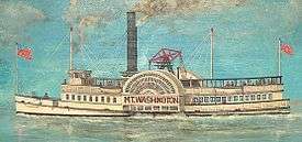
The paddlesteamer MS Mount Washington, named after the highest of New Hampshire's White Mountains, was launched in spring 1872 to carry mail, goods, and passengers on Lake Winnipesaukee, under the flag of the Boston and Maine Railroad. With a hull length of 178 feet (54 m) and a beam of 49 feet (15 m) she appeared as a typical representative of the North American sidewheelers around the second half of the century and was the largest steamer on the lake at that time. The huge paddle wheels were driven by a single-cylinder steam engine of 450 hp (340 kW) at approximately 26 rpm. The power was transferred from the vertical single cylinder to the wheel shaft by the walking beam, high above the upper deck, oscillating in the frequency of the paddle wheels. Known as "The Mount", her kitchen and restaurant service became famous.
On December 23, 1939, a nearby railroad station caught fire from an overheated stove. The fire soon spread to the ship, tied at the dock, and destroyed it. Efforts to cut Mount Washington loose were to no avail as it was a time of extremely low water and the hull was stuck fast in the mud of the lake bottom. Soon after, a local company was formed to build a new ship. Since Europe was already at war, obtaining steel was impossible. Instead, they purchased an old sidewheel vessel on Lake Champlain: the Chateaugay, a 203-foot (62 m), iron-hulled sidewheeler that was being used as a club house for the Burlington yacht club. It was cut into sections and transported to Lake Winnipesaukee on rail cars. A new twin-screw vessel was designed for the hull being welded back together at Lakeport. Powered by two steam engines taken from another ocean-going yacht, the new MS Mount Washington made her maiden voyage on August 15, 1940.
Two years after her launch, the new Mount Washington's engines were removed for use in a navy vessel during World War II. After the war, Mount Washington returned to the water. The ship was a success in the post-war tourist boom.[13]
In 1982, Mount Washington was cut open and extended with an additional 20-foot (6.1 m) hull section to add larger lounge and food service facilities. Still popular, she makes one or two round trips on the lake per day during the summer season, as well as numerous dinner dance cruises in the evenings.
US mailboat M/V Sophie C
The M/V Sophie C is the oldest, and one of only two currently operating, floating United States Postal Service post offices. Floating post office service was started on Lake Winnipesaukee in 1892, and currently delivers mail daily to eight of the lake's islands between June and September. As a floating post office, Sophie C delivers mail Monday-Saturday, sells postage, and collects and postmarks outgoing mail. Sophie C also operates as a sightseeing boat, carrying up to 125 people on her two cruises a day as she delivers mail, and sells ice cream and snacks to residents of the islands she serves.[14]
Seaplane base
The Alton Bay Seaplane Base is a state-owned, public-use seaplane base in Alton Bay, the southeast arm of the lake. In the winter it is the only FAA-approved ice runway in the contiguous United States, conditions permitting.[15]
Weather and climate
Average summertime on or next to the water brings days around 80 °F (26 °C), with overnight lows around 65 °F (18 °C). Less than one-half mile (800 m) away from the water, days can be warmer and nights cooler by several degrees. Summer's most extreme temperatures away from the water may be as high as 100 °F (38 °C) and as low as 50 °F (10 °C). A typical winter day brings a maximum of 28 °F (−2 °C) with overnight minimum around 15 °F (−9 °C). Typical wintertime extremes are 50 °F (10 °C) and −20 °F (−30 °C) but even greater extremes have been recorded nearby.
The water temperature typically reaches the upper 70s F (around 25 °C) in late July and cools into the 60s (around 18 °C) in September. Several days of hot, humid weather at the height of summer can bring the water temperature well above 80 °F (26 °C). It normally freezes during the last week of December. Ice thickness during a typical winter can be in excess of 18 inches (460 mm) in many parts of the lake.
Ice-Out
Lake Winnipesaukee is known for its annual Ice-Out Contest, in which people try to guess the earliest date that the Mount Washington can safely leave her port in Center Harbor and motor to four other ports (Weirs Beach, Alton Bay, Wolfeboro, and Meredith). Since records began in 1851, ice-out has happened as early as March 18[16] and as late as May 12, although 90 percent of the time it is declared during April. This official ruling is made by David Emerson of Emerson Aviation.[17]
In popular culture and the arts

- Thornton Wilder's 1938 Pulitzer Prize-winning play, Our Town, refers to Lake Winnipesaukee at the beginning of Act III.
- In a Three Stooges 1940 short "No Census, No Feeling", the Stooges are census takers, and Curly answers a query about his birthplace with "Lake Winnipesaukee". When Moe asks him to spell it, he switches course, and says "Make it Lake Erie - I've got an uncle there."[18]
- Some boating scenes from the 1981 Academy Award-winning film On Golden Pond were shot on the lake, though the main scenes were from nearby Squam Lake.
- In 1982, composer Alan Hovhaness, who spent much of his childhood in New Hampshire, composed Lake Winnipesaukee, Op. 363, a sextet for flute, oboe, cello, two percussion, and piano.
- The 1991 movie comedy What About Bob? was set at Lake Winnipesaukee, although the actual filming was done at Smith Mountain Lake in Virginia.
- The 2006 comedy Click has a flashback depicting Adam Sandler as a kid playing on a beach on Lake Winnipesaukee.
- In the debut of Adam Sandler's "Thanksgiving Song", on Saturday Night Live (November 21, 1992), the long-time New Hampshire resident sings, "I used to go to camp at Lake Winnipesaukee".[19]
- On The Tonight Show Starring Jimmy Fallon, host Jimmy Fallon and frequent guest Justin Timberlake have filmed a series of sketches set at a fictional "Camp Winnipesaukee".[20]
See also
References
- 1 2 3 Bizer's list of islands of Lake Winnipesaukee
- ↑ New Hampshire GRANIT database
- 1 2 Heald, Bruce D. (1 May 1998). Boats and Ports of Lake Winnipesaukee. Arcadia Publishing. ISBN 978-1-4396-2199-8.
- ↑ "Lakeport Dam (LKPN3)". NH Dept. of Environmental Services. Retrieved May 20, 2016.
- 1 2 Heald, Bruce (2001). Lake Winnipesaukee. Charleston, South Carolina: Arcadia Publishing. ISBN 9780738523552.
- ↑ Wilkin, Elizabeth Crawford (1949). Winnipesaukee Whoppers: Fabulous Legends of the Lake Once Called Winnipiseogee. Melvin Village, New Hampshire: Pine Point Press.
- ↑ McKenna, Robert (2003), The Dictionary of Nautical Literacy, McGraw-Hill Professional Reference, p. 157, ISBN 0-07-141950-0
- ↑ "The Harvard-Yale Regatta".
- ↑ U.S. Geological Survey Geographic Names Information System: Lake Winnipesaukee
- ↑ Hook, J. N. (10 June 2014). All Those Wonderful Names. Open Road Media. p. 249. ISBN 978-1-4976-1186-3.
- ↑ Richardson, Tom (March 31, 2011). "Bill Raises Winnipesaukee 'Broads' Speed Limit". New England Boating. Retrieved 22 November 2014.
- ↑ "Lake Winnipesaukee Fun Facts in New Hampshire". Lake-Winnipesaukee-Travel-Guide. Retrieved June 23, 2014.
- ↑ Paul H. Blaisdell: Three Centuries on Winnipesaukee (1975). New Hampshire Publishing Company, Somersworth, N.H.
- ↑ "U/S Mail Boat, Sophie C. on Lake Winnipesaukee, NH". Cruise Mount Washington. Retrieved June 23, 2014.
- ↑ "Pilots Take Advantage of Runway on Frozen Lake Winnipesaukee". CBS Boston. February 28, 2015. Retrieved 2015-03-01.
- ↑ Dan Seufert (March 18, 2016). "Earliest Ice-Out Declared, First During Winter". New Hampshire Union Leader. Retrieved March 27, 2016.
- ↑ Dan Seufert (April 23, 2014). "Ice-Out declared on Lake Winnipesaukee". New Hampshire Union Leader. Retrieved June 23, 2014.
- ↑ Three Stooges "No Census, No Feeling"
- ↑ "Pop culture in and around the Lakes Region". Bizer.com. Retrieved June 23, 2014.
- ↑ Schnurr, Samantha. "Justin Timberlake and Jimmy Fallon Return to Camp Winnipesaukee to Wreak Musical Havoc". E-Online. E! Entertainment Television. Retrieved 3 November 2016.
External links
| Wikimedia Commons has media related to Lake Winnipesaukee. |
- LakeWinnipesaukee.info
- LakeWinnipesaukee.net
- Winnipesaukee.com
- Lake Winnipesaukee Gallery at Whitemountainart.com
- Lake Winnipesaukee Historical Society
- Lakes Region Conservation Trust
- Lake level graphs, NH Dept. of Environmental Services
- Rattlesnake Island website
- "Lake Winnipesauke {{sic}} Steamer" watercolor (1893) by D.J. Kennedy; Historical Society of Pennsylvania
Webcams
- Alton Bay – WinnipesaukeeCam
- Bear Island Conservation Association – BearCam
- Black Cat Island – Lake Winnipesaukee WeatherCam
- Rattlesnake Island
- Weirs Beach – WeirsCAM
- Weirs Channel
- Wolfeboro Bay – WolfeboroCam