Lake Waikaremoana
| Lake Waikaremoana | |
|---|---|
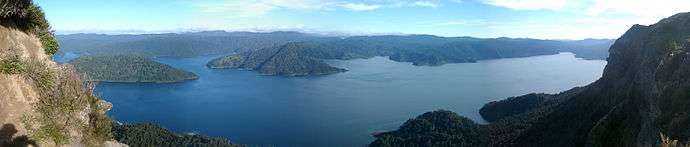
.JPG) Lake Waikaremoana (winter 2015) | |
| Location | Wairoa District, Hawke's Bay Region, North Island |
| Coordinates | 38°46′S 177°05′E / 38.767°S 177.083°ECoordinates: 38°46′S 177°05′E / 38.767°S 177.083°E |
| Primary outflows | Waikaretaheke River |
| Basin countries | New Zealand |
| Surface area | 54 km² |
| Max. depth | 256 m |
| Shore length1 | 102.3 km |
| Surface elevation | 600 m |
| Settlements | Āniwaniwa |
| 1 Shore length is not a well-defined measure. | |

Lake Waikaremoana is located in Te Urewera National Park in the North Island of New Zealand, 60 kilometres northwest of Wairoa and 80 kilometres west-southwest of Gisborne. It covers an area of 54 km². From the Maori Waikaremoana translates as 'sea of rippling waters'
The lake lies in the heart of Tuhoe country. The hamlet of Āniwaniwa and the Waikaremoana Holiday Park are located on the lakeshore, along SH38 (from Wai-O-Tapu via Murupara to Wairoa), which connects the lake to the central North Island (Rotorua) and Gisborne. There is a Department of Conservation office at Aniwaniwa. Several walks start here, including a short stroll to Aniwaniwa Falls.
Lake Waikaremoana is a holiday destination by people who use the lake for fishing, tramping and other recreational activities. The Lake Waikaremoana Track, one of New Zealand's "Great Walks", is a three- to four-day tramp which follows approximately half of the lake's circumference. The track can be walked independently, or as part of a guided group. There are huts dotted on the walk which require booking to use. Camping is permitted unless you are more than 500 metres from the track.
The climate of the area is temperate In the summer and cool during the winters, snowfalls occur a few times a year in the region.
Numbers of visitors to the area are mitigated by the unsealed road that must be taken to reach it. The smaller Lake Waikareiti lies four kilometres to the northeast.
Geography, natural history and climate
Waikaremoana, the North Island's deepest lake (256 m deep), has its surface at 600 metres above sea level. A huge landslide dam about 250 metres high formed the lake around 2,200 years ago.[1] Before the landslip was sealed, around 1950, much of the lake outflow flowed through the landslip rather than out of an overflow at a low point in the slip.[1]
Other geographical features include Panekiri Bluff and Puketukutuku Peninsula, which is the site of a kiwi-conservation programme. Surrounded by mountains clad with native forest which has never been logged, Waikaremoana is regarded as the North Island's most attractive lake. Many native bird-species scarce in most other parts of the North Island occur in the area. A possum-hunting programme operates in the area to help protect the forest. Numerous understory species grow within the forested area of the catchment basin, crown fern, Blechnum discolor, for example.[2] Since at least the early 1900s lake-bottom molluscs have been studied by Colenso (1811-1899) and others.[3]
The climate of Lake Waikaremoana is temperate during the summer months and cool in the winter where snow events are not unheard of. Heavy rains affect the region, especially about late winter and early spring. The weather in the area is very changeable, trampers in the region need to be on the look out for dangerous weather conditions.
Hydroelectric power scheme
.JPG)
The Waikaremoana Hydroelectric Power Scheme appears to be the only example of a hydroelectric power station being built on a natural landslide dam.
Modifying the natural dam
The stability of the natural dam has been the subject of intense engineering review, both at the time of construction and subsequently. Construction of an outlet tunnel through the slip, which commenced in 1935, required extensive grouting around the control structures and throughout tunnel construction. Work was suspended at the end of 1936 because Bob Semple, the newly elected Minister for Public Works, wanted the tunnelling project reconsidered for "risk, cost and value". A new tunnelling scheme was devised in 1941 based on what had been learned from initial exporatory tunnelling and work recommenced in 1943 and continued for about 5 years because of continual problems with dewatering the tunnels. After the tunnels and intake headworks had been completed the natural dam was sealed for leaks on the lake side by removing submerged timber, a task that took a year and then applying 40,000 cubic metres of crushed rock and clay-like pumice in 6 layers, then covering those layers with a top layer of larger rock and spalls to protect the material from wave action. This sealing reduced the natural flow by about 80%. The sealing of the lake was only done after tunnelling was completed otherise it would have caused the lake level to rise and make tunnelling more difficult. As it was, the lake level had to be lowered by temporary syphons to enable the construction of the headworks and make sealing of the natural dam easier.[1]
Power stations
Although the Waikaretaheke River carries a flow of about 17 m³/s from Lake Waikaremoana, the head of water through the 3 power stations, Kaitawa, Tuai, and Piripaua is around 450 metres, allowing the stations to potentially generate 138 megawatts all up. The 250m head of water for the Kaitawa station is the highest for a dam in New Zealand and among the highest in the world.[1]
See also
References
- C. Michael Hogan. 2009. Crown Fern: Blechnum discolor, Globaltwitcher.com, ed. N. Stromberg
- New Zealand Department of conservation. 2009. Te Urewera National Park
- Royal Society of New Zealand. 1905. Transactions of the Royal Society of New Zealand, v. 1-76; v. 77, pts. 1-5; v. 78-88
Line notes
Gallery
External links
| Wikimedia Commons has media related to Lake Waikaremoana. |
- Wairoa District Council Waikaremoana page
- Department of Conservation Waikaremoana Track page Department of Conservation
- Photos of Waikaremoana and the track
- Waikaremoana Holiday Park
- Live-aboard fishing tours on the lake