Lake Tōya
| Lake Tōya 洞爺湖 | |
|---|---|
 Lake Tōya (September 2013) | |
| Location | Iburi Subprefecture, Hokkaidō |
| Coordinates | 42°34′44″N 140°51′16″E / 42.57889°N 140.85444°ECoordinates: 42°34′44″N 140°51′16″E / 42.57889°N 140.85444°E |
| Type | oligotrophic crater lake |
| Primary inflows | Ō River (大川 Ō-gawa), Sōbetsu River (ソウベツ 川 Sōbetsu-gawa) |
| Primary outflows | Sōbetsu River (壮瞥川 Sōbetsu-gawa) |
| Basin countries | Japan |
| Max. length | 10 km (6.2 mi) |
| Max. width | 9 km (5.6 mi) |
| Surface area | 70.7 km2 (27.3 sq mi) |
| Average depth | 117.0 m (383.9 ft) |
| Max. depth | 180 m (590 ft) [1] |
| Water volume | 8.19 km3 (1.96 cu mi) |
| Shore length1 | 46 km (29 mi) [2] |
| Surface elevation | 84 m (276 ft) |
| Frozen | never |
| Islands | Nakano-shima |
| Settlements | Sōbetsu, Hokkaidō, Tōyako, Hokkaidō |
| References | [1][2] |
| 1 Shore length is not a well-defined measure. | |
Lake Tōya (洞爺湖 Tōya-ko) is a volcanic caldera lake in Shikotsu-Toya National Park, Abuta District, Hokkaidō, Japan. It is a part of "Toya Caldera and Usu Volcano Global Geopark" which joins in Global Geoparks Network. The stratovolcano of Mount Usu lies on the southern rim of the caldera. The lake is nearly circular, being 10 kilometers in diameter from east-west and 9 kilometers from North-South. The lake's biggest town, Tōyako is located on its western shore. The town Sōbetsu is located on the other side of the lake.
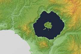

Lake Tōya is said to be the northernmost lake in Japan that never ices (with competing claim by nearby Lake Shikotsu), and the second most transparent lake in Japan. Nakajima Island (not to be confused with another island of the same name in Lake Kussharo) is an island in the middle of the lake which houses the Tōya Lake Forest Museum.
Lake Tōya was called Kim'un-to (キムウン (kim'un) means "in the mountain"[3] and ト (to) means "lake"[3]) by the Ainu. In the Meiji era, Japanese pioneers named the lake Tōya after the Ainu expression to ya, which means "lakeland".[3]
The 2008 G8 Summit was held at Lake Tōya and The Windsor Hotel Toya Resort & Spa.
In popular culture
- In the anime Gintama Lake Tōya (洞爺湖 Tōya-ko) is engraved on the Bokutō of the main character Gintoki Sakata (坂田 銀時, Sakata Gintoki).
- It is the model for Lake Kiriya in the anime Celestial Method.
References
- 1 2 Geographical Survey Institute map 25000:1 洞爺
- 1 2 Bisignani, J.D. (December 1993). Taran March, ed. Japan Handbook (Second ed.). Chico, California: Moon Publications, Inc. p. 781. ISBN 0-918373-70-0.
- 1 2 3 Batchelor, John. (1905) An Ainu-English-Japanese Dictionary (Second ed.). Tokyo: Methodist Publishing House
- "Usu". Global Volcanism Program. Smithsonian Institution.
- Geographical Survey Institute, last access 28 May 2008
- (Japanese) Japanese Wikipedia article
External links
- Guide of Lake Toya
- Toya Usu Geopark
- Toya Caldera - Geological Survey of Japan