Lake Rotomahana
| Lake Rotomahana | |
|---|---|
 Black swan on Lake Rotomahana | |
| Location | North Island |
| Coordinates | 38°16′S 176°27′E / 38.267°S 176.450°ECoordinates: 38°16′S 176°27′E / 38.267°S 176.450°E |
| Lake type | crater lake |
| Primary outflows | none |
| Basin countries | New Zealand |
| Max. length | 6.2 km (3.9 mi)[1] |
| Max. width | 2.8 km (1.7 mi)[1] |
| Surface area | 8.0 km2 (3.1 sq mi)[1] |
| Average depth | 51 m (167 ft)[1] |
| Max. depth | 112.4 m (369 ft)[1] |
| Surface elevation | 337 m (1,106 ft)[2] |
| References | [1] |
Lake Rotomahana is an 800-hectare (2,000-acre)[1] lake in northern New Zealand, located 20 kilometres to the south-east of Rotorua. It is immediately south-west of the dormant volcano Mount Tarawera, and its geography was substantially altered by a major 1886 eruption of Mount Tarawera. Along with the mountain, it lies within the Okataina caldera.
Before the 1886 eruption, only two small lakes were present in the current lake's basin. Following the eruption, a number of craters filled over the course of 15 years to form today's Lake Rotomahana. It is the most recently formed larger natural lake in New Zealand, and the deepest in the Rotorua district. The lake's northern shore lies close to the 39 metres (128 ft) lower Lake Tarawera, separated by less than 700 metres (2,300 ft) of terrain that is mostly material from the 1886 eruption. Lake Rotomahana has no natural outlet, and its water level varies by about one meter in response to rainfall and evaporation.[3]
The lake is a wildlife refuge, with all hunting of birds prohibited. A healthy population of black swan inhabits the lake, and there are efforts underway to ensure the lake's largest island, Patiti Island, is kept pest-free.[4]
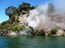
A boat cruise on the lake, visiting hydrothermal features on the lake's shore, is available as an additional extra from the Waimangu Volcanic Valley tourism operation.
Pink and White Terraces
The Pink and White Terraces were a natural wonder on the shores of the lake before the 1886 eruption. They were considered to be the eighth wonder of the natural world and were New Zealand's most famous tourist attraction during the mid 19th century, but were buried or destroyed by the eruption.
Scientists rediscovered the lower tiers of the Pink and White Terraces on the lake bed at a depth of 60 metres (200 ft) in 2011.[5]
References
- 1 2 3 4 5 6 7 Lowe, D.J., Green, J.D. (1987). Viner, A.B., ed. Inland waters of New Zealand. Wellington: DSIR Science Information Publishing Centre. pp. 471–474. ISBN 0-477-06799-9.
- ↑ LINZ Topo50 Map BF37
- ↑ Information panel at Lake Rotomahana's shore
- ↑ "Patiti Island Environmental Restoration". Waimangu Volcanic Valley. Retrieved 2014-12-30.
- ↑ Wylie, Robin (28 April 2016). "A natural wonder lost to a volcano has been rediscovered". earth. BBC.
External links
| Wikimedia Commons has media related to Lake Rotomahana. |