Lake Ngozi
| Lake Ngozi | |
|---|---|
 | |
| Coordinates | 9°00′29″S 33°33′11″E / 9.008°S 33.553°ECoordinates: 9°00′29″S 33°33′11″E / 9.008°S 33.553°E |
| Type | Crater lake |
| Catchment area | 4,6 km2 |
| Basin countries | Tanzania |
| Max. length | 2,5 km |
| Max. width | 1,6 km |
| Surface area | 3,1 km |
| Max. depth | 74 m |
| Water volume | 72.7 × 10⁻³ km3 |
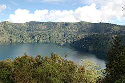
Lake Ngozi is the second largest crater lake in Africa.[1] It can be found near Tukuyu, a small town in the highland Rungwe District, Mbeya Region, of southern Tanzania in East Africa. It is part of the Poroto Ridge and part of the caldera rim is the highest point of the Ridge and mostly composed from trachytic and phonolitic lavas. Ngozi is a Holocene caldera that generated the Kitulo pumice 12,000 years ago during a Plinian eruption, most likely in the same eruption that generated the caldera. Other eruption deposits are the Ngozi Tuff (less than thousand years ago) and the Ituwa Surge base surge deposits of uncertain age, but intermediary to the Kitulo pumice and Ngozi Tuff. The youngest activity generated a pyroclastic flow that flowed southwards for 10 km around 1450 CE. Some pyroclastic cones surround the volcano. The walls of the caldera are forested, with the exception of segments scoured by landslides and high cliffs that inhibit access to the water. The inner caldera is forested with Maesa lanceolata, Albizia gummifera and Hagenia abyssinica, far fewer tree species than neighbouring mountains consistent with the recent geological origin of the volcano. The caldera itself is not subjected to hydrothermal activity, but large subaqueous CO2 emissions and local legends of the killing power of the lake indicate a danger of limnic eruptions. The lake floor according to echosounding is flat and has no terraces.[2][3][4]
The lake does not undergo large scale fluctuations in lake level, with only minor differences between the dry and rainy seasons. Air temperatures above the lake are around 18 °C with only minor seasonal variations.[3]
Sporadically, the forests were occupied by Safwa hunters. Reports in 2013 stated that in the following year a geothermal project would commence in the vicinity of the volcano halfway between Ngozi and the town of Mbeya.[1][3]
References
- 1 2 "Tanzania to start geothermal exploration at Lake Ngozi in 2013". Think Geoenergy. Archived from the original on 13 January 2015. Retrieved June 29, 2015.
- ↑ "Ngozi". Global Volcanism Program. Smithsonian Institution. Retrieved 29 June 2015.
- 1 2 3 Manuëlla Delalande-Le Mouëllica; Fabrizio Gherardi; David Williamson; Stephen Kajula; Michael Kraml; Aurélie Noret; Issah Abdallah; Ezekiel Mwandapile; Marc Massault; Amos Majule; Laurent Bergonzini (March 2015). "Hydrogeochemical features of Lake Ngozi (SW Tanzania)". Journal of African Earth Sciences. 103: 153–167. doi:10.1016/j.jafrearsci.2014.11.004. (registration required (help)).
- ↑ Nils Lenhardt; Gert-Jan Peeters; Athanas S. Macheyeki (April 2015). "The Ituwa Surge deposits of the Holocene Ngozi caldera, Mbeya Region, Tanzania". International Journal of Earth Sciences. 104 (3): 749–751. doi:10.1007/s00531-014-1113-7 – via Springer Link.