Lake Memphremagog
| Lake Memphremagog Lac Memphrémagog | |
|---|---|
 Lake Memphremagog | |
| Location |
Memphrémagog Regional County Municipality, Quebec, Canada; Orleans County, Vermont, United States |
| Coordinates | 45°0′18″N 72°13′53″W / 45.00500°N 72.23139°WCoordinates: 45°0′18″N 72°13′53″W / 45.00500°N 72.23139°W |
| Catchment area | 686 sq mi (1,777 km2) |
| Basin countries | Canada / United States |
| Max. length | 32 mi (51 km) |
| Surface area | 41 sq mi (110 km2) |
| Average depth | 15.5 m (51 ft) |
| Max. depth | 107 m (351 ft) |
| Surface elevation | 208 m (682 ft) |
| Islands | 20 |
Lake Memphremagog (French: Lac Memphrémagog) is a fresh water glacial lake located between Newport, Vermont, United States and Magog, Quebec, Canada.[1] The lake spans both Quebec and Vermont, but is mostly in Quebec. Most of the watershed that feeds the lake is located in Vermont, and is a source for accumulated phosphorus, sediments and other pollutants. Recent cleanup efforts have started to improve the water quality. The lake furnishes potable (drinking) water for 200,000 people.
Physical characteristics
The lake is 31 miles (50 km) long with 73 percent of the lake's surface area in Quebec, where it drains into the Magog River.[2] However, three-quarters of its watershed, 489 square miles (1,270 km2), is in Vermont. The total is 687 square miles (1,780 km2), with 198 square miles (510 km2) located in Quebec.[3] In Vermont, the lake lies in parts of the towns of Derby and Newport, in addition to the City of Newport, all in Orleans County. In Quebec, the lake lies in parts of Austin, Magog, Ogden, Potton, Saint-Benoît-du-Lac, and Stanstead Township, all in Memphrémagog Regional County Municipality. The lake occupies most of what the Vermont Agency of Natural Resources calls "Basin 17."[4] At the very south end of the lake, there is the South Bay, connected by the narrowest part of the lake.
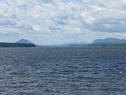
The lake elevation is 682 feet (208 m). Both ends of the lake are fairly shallow, with depth ranges of 20 feet (6.1 m) to 30 feet (9.1 m). The lake bottom takes a dramatic drop in Canada, starting opposite Mount Owl's Head and continuing that way north to Gibraltar Point, where it starts to climb back to the shallows of the north end. Its maximum recorded depth of 351 feet (107 m) is located in Canada, opposite Jewett Point (at approximately 45.111621, -72.278491). The lake is the third deepest in Vermont.[5][6] It contains 20 islands. Province Island, the largest, is divided by the international border.[7] The lake is irregular in shape, and along its shores are several striking indentations, in some places low, and in some other parts high and rocky.[8] Along the western shore of the lake are several mountains, prominent among which are Owl's Head, Elephantis, and the Hog's Back.[9]
Hydrology
Four Vermont rivers directly empty into the lake: the Clyde, Barton, the Black and the Johns River.
In the middle of the winter, the ice can become 3 feet (0.9 m) thick.[10]
The Quebec Magog River drains the lake towards the northeast.
Geology
During the ice age, the lake was a proglacial lake[11]:122 which covered Lake Magog, Lake Brompton, and much of the Saint François watershed including East Angus, Sherbrooke, and Windsor.[11]:121
Ecology
Like many other lakes, Memphremagog is accumulating phosphorus, sediments, and other pollutants, primarily runoff from farms, but from other sources as well. Exotic species infestations are a concern, with an existing Eurasian water milfoil population and the potential for a zebra mussel infestation. Since the 1970s, significant efforts have been made to reduce the polluting effects of direct discharges into the lake and its tributaries, and lake quality has improved.
In 1994, the Lake Memphremagog Watershed Association was formed to focus on solving lake and river issues.[12] Testing done in 2008 was unable to determine the cause of excessive nitrogen and phosphorus.[13] In 2010, a study revealed that farms contribute disproportionately to nutrient loads. Although farms have 16% of total land use in the drainage area, they produce 44% of the runoff. Baseline nutrients for a lake are 14 micrograms of phosphorus per litre of water. The lake was measured at 17 micrograms, 18% above the standard. Although the acreage devoted to farming has decreased, the retired land has most often been developed, itself a source of runoff.[14]
Origin of name
The lake is within the larger territory originally inhabited by the Abenaki tribe. The lake's name, Memphremagog, is derived from the Algonkian language:[15]
- Memphremagog comes from the word Memrahabegek, which means "where there is a big expanse of water".
- Memphremagog was also pronounced as "Mamphremagog". This came from the Abenakis' Mamlawbagak which signifies "a long and large sheet of water". The prefix mamlaw denotes largeness or abundance; the particule baga denotes water; and "k" marks the name as given in local term.[16]
History

In 1753, the Abenakis brought the ransomed John Stark down the lake and came ashore where Newport is now.
Rogers' Rangers were forced to retreat south following their attack on Saint-Francis, Quebec in 1759. To confound their avenging pursuers, they split up on the east shore of the lake.[17]
The first accurate depiction of the map was in 1776. This marks the beginning of interest by settlers.[18]
The Mountain Maid paddlewheeler operated from 1850 to 1870.[19] The Lady of the Lake steam excursion/ferry paddlewheeler started operating in 1867. It stopped operations in 1917. It was based in Newport. The Anthemis steamer was built in 1909 to carry 300 people. It stopped operating after 1945.[19]
In August 1942, a single-engined Royal Canadian Air Force training plane crashed into the lake near the west shore near Newport, killing the pilot, its only occupant.[20]
In 2010 the U.S. Fish and Wildlife Service accepted a bequest of 420 acres (170 ha) undeveloped land on the shores the lake on Eagle Point along the border with Canada. [21]
Memphre
Lake Memphremagog allegedly contains a cryptid named Memphre (or Memphré), which has received sightings since the 18th century and continues on in the folklore of the area.[22] A sighting of Memphre was reported in 2000.[23][24][25]
Lighthouses
Lake Memphremagog is known to have had at least three lighthouses on the Vermont side and seven on the Quebec side. These were used in aiding boaters in navigating the waters of the large lake.
Vermont lighthouses
All three of the original lighthouses have been demolished.
Maxfield Point Light

The Maxfield Point Light was a small lighthouse constructed on the Vermont side of Lake Memphremagog in 1879. A conical, cast iron structure, it was 25 feet (7.6 m) tall, with a focal plane 40 feet (12.2 m) above sea level. It showed a fixed white light, visible for 10 (16 km) miles. The lighthouse no longer exists; it is unknown what happened to it, or when it was deactivated.[26]
Newport Wharf Light
The Newport Wharf Light was a tower that was built in the Newport section of Lake Memphremagog in 1879. The lighthouse was a steel skeleton tower, painted red, that was fixed on a concrete foundation. The tower showed a fixed red light that was visible for up to 12 mi (19 km), with the height of the focal plane being 37 feet (11.2 m). As with the Maxfield Point Lighthouse, the date this lighthouse was demolished is unknown.[27]
Whipple Point Light
Whipple Point Light was a tower that was built on the end of a pier on Whipple Point in Lake Memphremagog. Built in 1879, the tower was constructed of wood in a hexagonal shape and stood 13 feet (4 m). The light was fixed white and was visible from up to 10 mi (16 km) away, with a focal plane of 25 feet (7.6 m). The lighthouse was deactivated around 1906 and was demolished at an unknown date.[28]
Quebec lighthouses
Most of the Quebec lighthouses were originally established in 1878. None of the original lighthouses have survived, although some of them have been replaced by simple navigation lights. From north to south, the lighthouses were:
Magog Lighthouse
Magog Lighthouse was located on a freight shed and had a fixed red light with a range of 8 miles (13 km). It was built in 1910 and located near Magog. It was demolished on an unknown date.[29]
Witch Shoal Lighthouse
Witch Shoal Lighthouse was located about 0.5 miles (0.80 km) southwest of Magog. The original lighthouse was built in 1878 as a 21 feet (6.4 m) white square wooden tower on a pier. It had a fixed white dioptric light located at a height of 19 feet (5.8 m) above the high water mark and with a range of 9 miles (14 km).[30] It was rebuilt in 1900. In April 1933, it was destroyed by pressure from the ice caused by the rising level of the lake. It was rebuilt in 1960 as a small metal tower, which was swept away by spring ice in 1978. Since 1980, the mast that replaced it is left in place only from May to October each year. The tower is 23 feet (7.0 m) high with a fixed white light that has a range of 9 miles (14 km) and a focal plane of 28 feet (8.5 m). The aid is owned by the Coast Guard and maintained by a private contractor.[31]
Black Point Lighthouse
Black Point Lighthouse was located on the western side of the lake, about 3 miles (4.8 km) southwest from Witch Shoal lighthouse. It was also known as the Green Point Lighthouse. It was built in 1878 as a 22-foot (6.7 m) white square wooden tower. It had a fixed white catoptric light located at a height of 24 feet (7.3 m) above the high water mark and with a range of 8 miles (13 km).[30] It had a focal plane of 22 feet (6.7 m). It was rebuilt in 1914 and demolished on an unknown date.[32]
Wadleigh's Point Lighthouse
Wadleigh's Point Lighthouse was located on the western side of the lake, about 4 miles (6.4 km) southwest of Black Point lighthouse. It was also known as the Bryant Landing Light and was near Austin. The original lighthouse was built in 1878 as a 22-foot white square wooden tower with a fixed white catoptric light located at a height of 30 feet (9.1 m) above the high water mark and with a range of 8 miles (13 km).[30] In approximately 1914, that was replaced by a square pyramidal skeletal tower with enclosed lantern. In 1939, that was replaced by a 18 feet (5.5 m) square skeletal tower with enclosed lantern. In 1980, that was replaced by a modern 22 feet (6.7 m) steel tower with a fixed white light that has a range of 8 miles (13 km). The still-active light is installed from May to October each year.[33]
Chateau de Silva Lighthouse
Chateau de Silva Lighthouse was located on the western side of the lake at the Revere House (formerly the Chateau de Silva) hotel wharf, approximately 5 miles (8.0 km) southwest of the Wadleigh's Point lighthouse. It was built in 1878 as a 22 feet (6.7 m) white square wooden tower with a fixed white catoptric light located at a height of 20 feet (6.1 m) above the high water mark and with a range of 8 miles (13 km).[30] The light had a focal plane of 20 feet (6.1 m). It was demolished on an unknown date.[34]
Molson's Island Lighthouse
Molson's Island Lighthouse was located on the southwest point of Molson's Island, approximately 2 miles (3.2 km) southeast of the Chateau de Silva lighthouse. This was on the eastern side of the lake, near Georgeville. It was built in 1878 as a 22 feet (6.7 m) white square wooden tower with a fixed white catoptric light located at a height of 28 feet (8.5 m) above the high water mark and with a range of 8 miles (13 km).[30] The light had a focal plane of 28 feet (8.5 m). It was rebuilt in 1914 and demolished on an unknown date.[35] The light was replaced with a lighted buoy.
Lead Mines Lighthouse
Lead Mines Lighthouse was located on the western side of the lake, approximately 4 miles (6.4 km) southwest of the Molson's Island lighthouse. This was near Leadville, at the foot of Mount Owl's Head. It was built in 1878 as a 22 feet (6.7 m) white square wooden tower with a fixed white catoptric light located at a height of 20 feet above the high water mark and with a range of 8 miles (13 km).[30] The light had a focal plane of 22 feet (6.7 m). It was rebuilt in 1914 and demolished on an unknown date.[36]
Economy
The watershed in Vermont is largely agricultural and forest land with residential development increasing in recent years in both Vermont and Quebec.
The lake furnishes potable (drinking) water for 200,000 people.[4]
In 2011 a day cruise ship started summer operations on the Canadian side of the lake.[37]
Sargent's Bay Yacht Club
Sargent's Bay Yacht Club,[38] despite its name, is a small children's dinghy sailing club based out of Sargent's Bay. It operates throughout eight weeks of the summer, hosting up to 40 campers a week, with a staff of five to seven. It was started in 1935 by several families in the bay, with the goal of teaching their children the basics of the sport they all cherished so much, sailing. Since 1935, the Fisher family has graciously allowed the operation of the club to continue on their property.
Popular culture
Lake Memphremagog is mentioned in a novel by Chris Bohjalian, Close Your Eyes, Hold Hands, in which the lake is the site of a nuclear reactor that has suffered a cataclysmic meltdown.
Lake Memphremagog is mentioned in Northwest Passage, a historical novel by Kenneth Roberts about the 1759 Rogers' Rangers raid. In Northwest Passage, the 1940 film based on the novel, Spencer Tracy uses a map that shows Lake Memphremagog and the environs.
The 1986 film The Decline of the American Empire was shot at Lake Memphremagog from September to October 1985.[39]
The Canadian band The Tragically Hip mentions Lake Memphremagog in their 2002 unreleased song"'Problem Bears", part of their In Violet Light album sessions.
Lake Memphremagog was mentioned and depicted in Disappearances, a 2006 film by director Jay Craven starring Kris Kristofferson, and co-starring Charlie McDermott and Geneviève Bujold.
References
- ↑ "Géographie physique et Quaternaire, 1999, vol. 53". Late Wisconsinan Deglaciation and Glacial Lake Development in the Appalachians of Southeastern Quebec. Retrieved 2006-12-24.
- ↑ The Spell of Lake Memphremagog
- ↑ Vermont Department of Environmental Conservation (March 21, 2007). Meeting to establish Lake Memphremagog association. The Chronicle.
- 1 2 "Two local public meetings to discuss watershed plan". the Chronicle. Barton, Vermont. November 30, 2011. p. 38.
- ↑ Behind Lake Champlain at 405 feet (123 m) deep and Lake Willoughby at 302 feet (92 m) deep
- ↑ Lake Memphremagog Fishing in Orleans County
- ↑ Jacques Boisvert. "Province Island". Retrieved 2006-11-04.
It is the largest island in Lake Memphremagog, being 77 acres, of which 7 acres are in the United States.
- ↑
 Rines, George Edwin, ed. (1920). "Memphremagog". Encyclopedia Americana.
 - ↑ Ripley, George; Dana, Charles A., eds. (1879). "Memphremagog, Lake". The American Cyclopædia.
- ↑ Wheeler, Scott (February 2007). Standing On Thin Ice. Vermont Northland Journal.
- 1 2 Parent, Michel; Occhietti, Serge (1999). "Late Wisconsinan deglaciation and glacial lake development in the Appalachians of southeastern Québec". Géographie physique et Quaternaire. Érudit. 53 (1): 117–135. doi:10.7202/004859ar. Retrieved 31 July 2014.
- ↑ Lake Memphremagog
- ↑ The Chronicle, July 1, 2009, page 2A, "Search continues for sources of pollution," Richard Creaser
- ↑ Creaser, Richard (18 August 2010). "Watershed association seeks to combat farm runoff". Barton, Vermont: the Chronicle. p. 16.
- ↑ Philippe Charland: Définition et reconstitution de l'espace territorial du nord-est amériquain : la reconstruction de la carte du W8banaki par la toponymie abénakise au Québec Aln8baïwi Kdakina-- notre monde à la manière abénakise. Doctor of Philosophy thesis, Department of Geography, McGill University, Montreal, 2005
- ↑ Joseph Laurent, New Familiar Abenakis and English Dialogues, the First Ever Published on the Grammatical System. L. Brousseau 1884:p. 214
- ↑ Darrell Hoyt (1985). Sketches of Orleans, Vermont. Mempremagog Press. ISBN 0-9610860-2-5., page 1
- ↑ Lewis Evans / Thomas Pownall: A Map of the Middle British Colonies. "News". Retrieved September 29, 2016.
- 1 2 Wheeler, Scott (August 2007). "Remembering the Days of the Big Tour Boats with Dreams of Bringing Them Back to Life". Vermont's Northland Journal: 3–6.
- ↑ "Salvage Operations on Crashed Plane Now Underway". Derby, Vermont: the November 13, 1943 Newport Daily Express as quoted in the Northland Journal. September 2008. pp. 29–30.
- ↑ "US accepts stunning gift of land": accessed 31 August 2010.]
- ↑ Vermont Living Magazine
- ↑ APPARITION DU 4 JUIN 2000
- ↑ Mysterious sighting on Lake Memphremagog
- ↑ Memphre: Reports 2000
- ↑ Lighthouses at Lighthouse Depot ... Lighthouse Explorer Database ... Maxfield Point Lighthouse
- ↑ Lighthouses at Lighthouse Depot ... Lighthouse Explorer Database ... Newport Wharf Light
- ↑ Lighthouses at Lighthouse Depot ... Lighthouse Explorer Database ... Whipple Point Lighthouse
- ↑ Lighthouses at Lighthouse Depot ... Lighthouse Explorer Database ... Magog Lighthouse
- 1 2 3 4 5 6 Sixteenth Annual Report of the Department of Marine and Fisheries Being for the Fiscal Year Ended 30th June, 1882
- ↑ Lighthouses at Lighthouse Depot ... Lighthouse Explorer Database ... Witch Shoal Lighthouse
- ↑ Lighthouses at Lighthouse Depot ... Lighthouse Explorer Database ... Black Point Lighthouse
- ↑ Lighthouses at Lighthouse Depot ... Lighthouse Explorer Database ... Wadleigh Point Lighthouse
- ↑ Lighthouses at Lighthouse Depot ... Lighthouse Explorer Database ... Château da Silva Lighthouse
- ↑ Lighthouses at Lighthouse Depot ... Lighthouse Explorer Database ... Molson Island Lighthouse
- ↑ Lighthouses at Lighthouse Depot ... Lighthouse Explorer Database ... Lead Mines Lighthouse
- ↑ Escapades Memphrémagog :: Gourmet cruises on Lake Memphremagog, Magog, Qc. Escapadesmemphremagog.com. Retrieved on 2014-04-12.
- ↑ Sargent's Bay Yacht Club
- ↑ André Loiselle, Denys Arcand's Le Déclin de L'empire Américain and Les Invasions Barbares, University of Toronto Press, 2008, p. 23.
Further reading
- Abbott, Louise; Jensen, Niels (2014). Memphrémagog: an illustrated history. Georgeville, Québec: Georgeville Press. ISBN 978-0987969118.
- Monitoring and Assessment Work Group of the Quebec/Vermont Steering Committee on Lake Memphremagog (May 8, 2008). The Water Quality of Lake Memphremagog (PDF).
External links
- Memphremagog Conservation
- Lake Memphremagog, Coaticook & Tomifobia Rivers Basin Planning
- The International Dracontology Society of Lake Memphremagog
- Beautiful Waters (YouTube) - a short film about the lake