Lake Mahinapua
| Lake Mahinapua | |
|---|---|
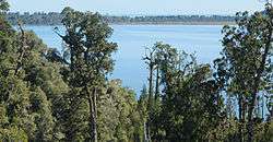 Lake Mahinapua viewed from the tower of the nearby Treetop Walkway | |
| Location | West Coast, South Island |
| Coordinates | 42°48′S 170°55′E / 42.800°S 170.917°ECoordinates: 42°48′S 170°55′E / 42.800°S 170.917°E |
| Primary inflows | Frosty Creek, Mirror Creek |
| Primary outflows | Mahinapua Creek |
| Basin countries | New Zealand |
| Max. length | 3 kilometres (1.9 mi) |
| Max. width | 2 kilometres (1.2 mi) |
| Surface area | 3 square kilometres (1.2 sq mi) |
| Surface elevation | 4 metres (13 ft) |
Lake Mahinapua is a shallow lake on the West Coast of New Zealand's South Island. It is about 10 kilometres (6 mi) south of Hokitika and near the small town of Ruatapu. It was formerly a coastal lagoon, but the buildup of coastal dunes made it an inland lake roughly 500 metres (1,600 ft) from the Tasman Sea coastline.
In 1907, the Lake Mahinapua Scenic Reserve was established to protect the land around the lake, and a number of short walking tracks run through this area.[1] In 2012, the West Coast Treetop Walk was opened nearby, which also offers views towards the lake. Other activities that take place around the lake are picnicking, camping, and various water-based activities. Species of birds such as black swans, grey ducks and mallard ducks live around the lagoon, while the surrounding bush provides a habitat for species such as parakeets and tui.
State Highway 6 passes between the lake and sea on its route between Hokitika and Ross. The Ross Branch railway also once ran past the lake; it opened to Ruatapu on 9 November 1906, was extended to Ross on 1 April 1909, and closed on 24 November 1980.
References
- ↑ "Mahinapua Scenic Reserve". Department of Conservation NZ. Retrieved 2015-03-18.
External links
| Wikimedia Commons has media related to Lake Mahinapua. |