Khövsgöl Nuur
| Lake Khuvsgul | |
|---|---|
 | |
| Coordinates | 51°06′N 100°30′E / 51.100°N 100.500°ECoordinates: 51°06′N 100°30′E / 51.100°N 100.500°E |
| Type | Rift lake |
| Primary outflows | Eg River |
| Basin countries | Mongolia |
| Max. length | 136 km |
| Max. width | 36.5 km |
| Surface area | 2,760 km2 (1,070 sq mi) |
| Average depth | 138 m |
| Max. depth | 267 m |
| Water volume | 480.7 km³ |
| Surface elevation | 1,645 m |
| Islands | Modon khui, Khadan khui, Modot tolgoi, Baga khui |
| Settlements | Khatgal, Khankh |
Lake Khövsgöl (Mongolian: Хөвсгөл нуур, Höwsgöl núr; classic script:![]() köbsügül naɣur), also referred to as Khövsgöl dalai (Хөвсгөл далай, Höwsgöl dalai; Khövsgöl ocean) or Dalai Eej (Далай ээж, Dalai éj; ocean mother), is the largest fresh water lake in Mongolia by volume, and second largest by area. Khövsgöl Nuur is nicknamed "Younger sister of the Sister Lakes (Lake Khövsgöl and Lake Baikal)".
köbsügül naɣur), also referred to as Khövsgöl dalai (Хөвсгөл далай, Höwsgöl dalai; Khövsgöl ocean) or Dalai Eej (Далай ээж, Dalai éj; ocean mother), is the largest fresh water lake in Mongolia by volume, and second largest by area. Khövsgöl Nuur is nicknamed "Younger sister of the Sister Lakes (Lake Khövsgöl and Lake Baikal)".
Geography
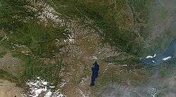
Khuvsgul nuur is located in the northwest of Mongolia near the Russian border, at the foot of the eastern Sayan Mountains. It is 1,645 metres (5,397 feet) above sea level, 136 kilometres (85 miles) long and 262 metres (860 feet) deep. It is the second-most voluminous freshwater lake in Asia, and holds almost 70% of Mongolia's fresh water and 0.4% of all the fresh water in the world.[1] The town of Hatgal is at the southern end of the lake.
Its watershed is relatively small, and it only has small tributaries. It is drained at the south end by the Egiin Gol, which connects to the Selenge and ultimately into Lake Baikal. Between the two lakes, the water travels a distance of more than 1,000 km (621 mi), and falls 1,169 metres (3,835 feet), although the line-of-sight distance is only about 200 km (124 mi). Its location in northern Mongolia forms one part of the southern border of the great Siberian taiga forest, of which the dominant tree is the Siberian Larch (Larix sibirica),
The lake is surrounded by several mountain ranges. The highest mountain is the Bürenkhaan / Mönkh Saridag (3,492 metres (11,457 feet)), which has its peak north of the lake exactly on the Russian-Mongolian border. The surface of the lake freezes over completely in winter. The ice cover in winter is strong enough to carry heavy trucks; transport routes were installed on its surface as shortcuts to the normal roads. However, this practice is now forbidden to prevent pollution of the lake from both oil leaks and trucks breaking through the ice. It is estimated that 30-40 vehicles have sunk into the lake over the years.
Ecological significance

Khuvsgul is one of seventeen ancient lakes in the world, being more than 2 million years old, and the most pristine (apart from Lake Vostok),[2][3] as well as being the most significant drinking water reserve of Mongolia. Its water is potable without any treatment. Hovsgol is an ultraoligotrophic lake with low levels of nutrients, primary productivity and high water clarity (secchi depths > 18 m are common). Hovsgol's fish community is species-poor compared to that of Lake Baikal. Species of commercial and recreational interest include Eurasian perch (Perca fluviatilis), burbot (Lota lota), lenok (Brachymystax lenok), and the endangered endemic Hovsgol grayling (Thymallus nigrescens). Though endangered by poaching during its spawning runs, the Hovsgol grayling is still abundant throughout much of the lake.[4]
The Lake area is a National Park bigger than Yellowstone and strictly protected as a transition zone between Central Asian Steppe and the Siberian Taiga. Despite Hovsgol's protected status, illegal fishing is common and prohibitions against commercial fishing with gillnets are seldom enforced. The lake is traditionally considered sacred in a land suffering from arid conditions where most lakes are salty.
The Park is home to a variety of wildlife such as ibex, argali, elk, wolf, wolverine, musk deer, brown bear, Siberian moose, and sable.
The Hövsgöl (Khövsgöl) Long-term Ecological Research Site (LTERS) was established in 1997 and an extensive research program began soon thereafter. Now part of an international network of long-term study sites, the Hövsgöl LTERS provides a stage for nurturing Mongolia's scientific and environmental infrastructures, studying climate change, and developing sustainable responses to some of environmental challenges facing the lake and its watershed.
Etymology and transliterations
The name Khövsgöl is derived from Tuvan language words for "Blue Water Lake,"[5] Nuur is the Mongolian word for "lake." There are a number of different transcription variants, depending on whether the Cyrillic "х" is transliterated to "h" or "kh," or whether the "ө" is transliterated to "ö," "o," or "u." Transcriptions from the name in the classical Mongolian script, like Hubsugul, Khubsugul etc. may also be seen.

References
- ↑ "The Aquatic Invertebrates of the watershed of Lake Hovsgol in northern Mongolia". Institute for Mongolia Research Guide. Retrieved 2007-07-13.
- ↑ worldlakes.org: lake Hovsgol, retrieved 2007-02-27
- ↑ Goulden, Clyde E. et al.: The Mongolian LTER: Hovsgol National Park, retrieved 2007-02-27
- ↑ DIVER Magazine, March 2009
- ↑ Shomfai, David Kara (2003) "Traditional musical life of Tuvans of Mongolia" in Melodii khoomei-III: 40, 80
External links
| Wikimedia Commons has media related to Lake Khövsgöl. |
- New York Times article about kayaking on Khövsgöl
- Limnological Catalog of Mongolian Lakes