Lake Herrera
| Lake Herrera | |
|---|---|
 Lake Herrera | |
| Location | Mosquera, Cundinamarca |
| Coordinates | 4°41′26″N 74°16′29″W / 4.69056°N 74.27472°WCoordinates: 4°41′26″N 74°16′29″W / 4.69056°N 74.27472°W |
| Type |
Wetland Artificial lake (since 1973) |
| Part of | Bogotá savanna |
| Primary inflows |
Bojacá River Bogotá River (San José channel) |
| Primary outflows | none |
| Basin countries | Colombia |
| Max. length | 3 kilometres (1.9 mi) |
| Max. width | 1.5 kilometres (0.93 mi) |
| Surface area | 280 hectares (690 acres) |
| Average depth | 1.3 metres (4.3 ft) |
| Max. depth | 2 metres (6.6 ft) |
| Surface elevation | 2,550 m (8,370 ft) |
| References | [1][2] |
_nigrofasciatus_elongatulus_Pilsbry%2C_1898_-_Bulimulidae_-_Mollusc_shell.jpeg)
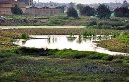
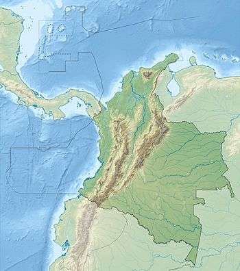
Lake Herrera is a small lake located at 5 kilometres (3.1 mi) from the urban centre of Mosquera and about 20 kilometres (12 mi) north of the capital Bogotá in Cundinamarca, Colombia. The Andean lake has made its name in the Herrera Period, the period in the history of central Colombia before the Muisca Period, after archaeologist Sylvia Broadbent excavated ceramics around Lake Herrera in 1971.[1]
Description
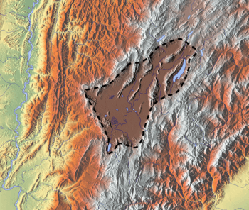
Lake Herrera is situated on the Bogota savanna; the southwestern part of the Andean high plateau in the Eastern Ranges; the Altiplano Cundiboyacense. The lake is one of many remainders of the Pleistocene Lake Humboldt.[1] It is the largest remaining natural water reserve on the Bogotá savanna and the reserve belongs to the municipalities Mosquera, Madrid and Bojacá.[3]
History
Investigations by archaeologist Gonzalo Correal Urrego in 1984 have revealed the existence of a preceramic site with two layers. The oldest layer has been dated at 3410 years BP and the younger layer at 3135 BP.[4]
Correal Urrego has discovered preceramic tools and wooden beams in horizontal position, possibly used to against the lake overflowing. Different stone tools found are scrapers and chips with sharp edges. Other tools were handles, and white-tailed deer bone tools for perforation, scarping and cutting. Evidence of fireplaces and burial grounds has been uncovered. One of the burial sites contained a full skeleton surrounded by five skulls. Remains of fauna collected by the hunter-gatherers were mammals, birds and snails. The presence of basalt, not formed on the Altiplano, indicated movement from the Magdalena Valley.[4]
When the climatic conditions became drier and layers of volcanic ash were deposited around the lake in the first millennium BCE, the inhabitants of the region started to develop agriculture around the lake.[5]
Later excavations have provided ceramic with a typical red colour, rich in SiO2.[6]
The lake is a residual part of Lake Humboldt, but since 1973 functions as an artificial lake after the construction of drainage channels. The lake is fed from the Bojacá River from the northeast and from the San José channel, fed by the Bogotá River in the southwest. Between 1969 and 2013 the surface area of the lake has been reduced with 175 hectares (430 acres).[2]
Recent mining activities close to the lake endanger the environment of Lake Herrera, formalised a water reserve on July 23, 2006.[3][7]
Biodiversity
Flora and fauna around the lake is endangered and migrating birds use Lake Herrera.[1] Several species have been found and described in and around the lake:
- thickhead ground snake (Atractus crassicaudatus)[8]
- Cheilanthes myriophylla[9]
- Drymaeus nigrofasciatus[10]
- Stenocercus trachycephalus[11]
Tourism
The lake can be visited and walked around, although some parts are privately owned and access permits have to be arranged.[2]
Trivia
- Another name for Lake Herrera and its surroundings is Sabrisky Desert[12]
See also
References
- 1 2 3 4 (Spanish) Description Lake Herrera
- 1 2 3 (Spanish) Lake Herrera on the official website Mosquera
- 1 2 (Spanish) Lake Herrera largest water reserve of the Bogotá savanna
- 1 2 (Spanish) Excavations Correal Urrego around Lake Herrera
- ↑ Rodríguez, 2005, p.105
- ↑ De Paepe & Cardale, 1990, p.100
- ↑ (Spanish) Mining activities endanger Lake Herrera - RCN
- ↑ Atractus crassicaudatus
- ↑ Cheilanthes myriophylla
- ↑ Borrero, F.J. - Colombian non-marine mollusks
- ↑ Stenocerus trachycephalus
- ↑ (Spanish) Sabrisky Desert around Lake Herrera
Bibliography
- Paepe, Paul de, and Marianne Cardale de Schrimpff. 1990. Resultados de un estodio petrológico de cerámicas del Periodo Herrera provenientes de la Sabana de Bogotá y sus implicaciones arqueológicas - Results of a petrological study of ceramics form the Herrera Period coming from the Bogotá savanna and its archaeological implications. Boletín Museo del Oro _. 99-119. Accessed 2016-07-08.
- Rodríguez, José Vicente. 2005. De la sabana a la selva - Un yacimiento formativo ritual en el entorno de la antigua laguna de La Herrera, Madrid, Cundinamarca - From the savanna to the jungle - a ritual formative site in the surroundings of the ancient Lake Herrera, Madrid. Maguaré 19. 103-131.
Further reading
- Broadbent, Sylvia M.. 1971. Reconocimientos arqueológicos de la Laguna Herrera. Revista Colombiana de Arqueología 1. 171-214.
External links
- (Spanish) Video Lake Herrera
| Prehistoric-preceramic |  | |
|---|---|---|
| Preceramic-ceramic | ||