Lake Guatavita
| Lake Guatavita | |
|---|---|
 | |
 Lake Guatavita | |
| Location | Sesquilé, Cundinamarca |
| Coordinates | 4°58′38″N 73°46′32″W / 4.97722°N 73.77556°WCoordinates: 4°58′38″N 73°46′32″W / 4.97722°N 73.77556°W |
| Primary inflows | Rain |
| Basin countries | Colombia |
| Max. length | 700 metres (2,300 ft) |
| Max. width | 700 metres (2,300 ft) |
| Surface area | 19.8 hectares (49 acres) |
| Max. depth | 125 metres (410 ft) |
| Surface elevation | 3,000 metres (9,800 ft) |
| References | [1][2][3] |

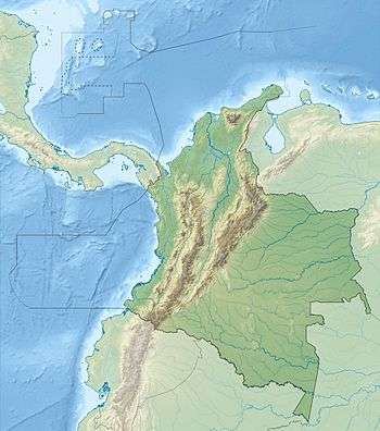
Lake Guatavita (Spanish: Laguna de Guatavita or Lago Guatavita) is located in the Cordillera Oriental of the Colombian Andes in the municipality of Sesquilé, in the Almeidas Province, Cundinamarca department of Colombia, 57 kilometres (35 mi) north-east of Bogotá, capital of Colombia.
The lake is circular and has a surface area of 19.8 hectares. The earlier theories of the crater's origin being a meteorite impact, volcanic cinder, or limestone sinkhole are now discredited. The most likely explanation is that it resulted from the dissolution of underground salt deposits from an anticline,[3] resulting in a kind of sinkhole.
There are hot springs nearby in the municipality of Sesquilé, which means "hot water".
While the existence of a sacred lake in the Eastern Ranges of the Andes, associated with Indian rituals involving gold, was known to the Spanish possibly as early as 1531, its location was only discovered in June 1537 by conquistador Gonzalo Jiménez de Quesada while on an expedition to the highlands of the Eastern Ranges of the Andes in search of gold. This brought the Spanish into first contact with the Muisca inhabiting the Altiplano Cundiboyacense, including around Lake Guatavita.
The lake is now a focus of ecotourism, and its association with the legend of El Dorado is also a major attraction.
Etymology
The name of the lake is derived from Chibcha, the language of the Muisca: gwa: mountain or gwata, gwate: high elevation, or gwatibita: high mountain peak; hence, a pool at a high mountain peak.[5] Another meaning is "End of the farmfields".[6]
Muisca mythology
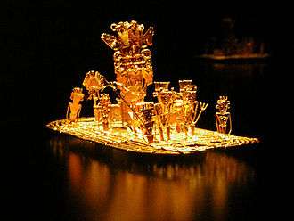
Lake Guatavita was reputedly one of the sacred lakes of the Muisca, and a ritual conducted there is widely thought to be the basis for the legend of El Dorado, "the golden one". The legend says the lake is where the Muisca celebrated a ritual in which the zipa (named "El Dorado" by the conquistadors) was covered in gold dust, then venturing out into the water on a ceremonial raft made of rushes, he dived into the waters, washing off the gold. Afterward, trinkets, jewelry, and other precious offerings were thrown into the waters by worshipers. A few artifacts of gold and silver found at bottom hold proof to this claim; however, to date, attempts to drain the lake or salvage the gold (see Lake Guatavita gold) have yielded no more than these.
Trivia
- Lake Guatavita is the filming location of the music video of the song No Te Pido Flores by Fanny Lú
See also
- Muisca religion
- Guatavita myth
- Lake Iguaque, another sacred lake of the Muisca
- Siecha Lakes, other lakes implicated in the El Dorado legend
- Tominé Reservoir, which buried the old town of Guatavita
- Tunjo, offer pieces in Lake Guatavita
- Gold Museum, Bogotá, where archaeological objects from the lake are displayed
References
- ↑ (Spanish) Google Maps Area Calculator
- ↑ (Spanish) Google Maps Elevation Finder
- 1 2 Dietz ,R.S.; McHone, J.F. (1972). "Laguna Guatavita: Not Meteoritic, Probably Salt Collapse Crater". Meteoritics. 7 (3): 303. doi:10.1111/j.1945-5100.1972.tb00444.x.
- ↑ British Museum Collection
- ↑ M. Louis Ghisletti, Los Mwiskas, Bogota, 1954
- ↑ (Spanish) Official website Guatavita
External links
| Wikimedia Commons has media related to Laguna de Guatavita. |
- (Spanish) Lake Guatavita - Colparques
Treasures of Colombia | |||||||||||||||||||||||||||||||||||||||||||||||||||||
|---|---|---|---|---|---|---|---|---|---|---|---|---|---|---|---|---|---|---|---|---|---|---|---|---|---|---|---|---|---|---|---|---|---|---|---|---|---|---|---|---|---|---|---|---|---|---|---|---|---|---|---|---|---|
Archaeological sites · Colombia magia salvaje · National monuments · National parks · World Heritage sites | |||||||||||||||||||||||||||||||||||||||||||||||||||||
| |||||||||||||||||||||||||||||||||||||||||||||||||||||
| |||||||||||||||||||||||||||||||||||||||||||||||||||||
| |||||||||||||||||||||||||||||||||||||||||||||||||||||
Source: Wills, Fernando et al. 2001. Nuestro patrimonio - 100 tesoros de Colombia - Our heritage - 100 treasures of Colombia, 1-311. El Tiempo. | |||||||||||||||||||||||||||||||||||||||||||||||||||||