Cami Lake
| Fagnano Lake | |
|---|---|
 | |
| Location | Ushuaia Department / Río Grande Department, Tierra del Fuego Province, Argentina / Tierra del Fuego Province, Magallanes and Antártica Chilena Region, Chile |
| Coordinates | 54°32′36″S 67°59′00″W / 54.54333°S 67.98333°WCoordinates: 54°32′36″S 67°59′00″W / 54.54333°S 67.98333°W |
| Primary outflows | Azopardo River |
| Basin countries | Argentina, Chile |
| Max. length | 98 km |
| Surface area | 645 km² |
| Max. depth | 200 m |
| Surface elevation | 140 m[1] |
| Settlements | Tolhuin |
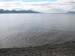
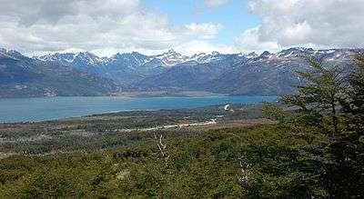
Fagnano Lake (Spanish: Lago Fagnano), also called Lake Cami (Spanish: Lago Cami), is a lake located on the main island of the Tierra del Fuego archipelago, and shared by Argentina and Chile.
The 645 km² lake runs east-west for about 98 kilometres, of which 72.5 km (606 km²) belong to the Argentine Tierra del Fuego Province, and only 13.5 km (39 km²) belong to the Chilean Magallanes y la Antártica Chilena Region. It has a maximum depth of 200 meters.
The southern bank is steep compared to the northern, and expands in a considerably wide and flat piedmont from which both levels of the plateaus can be appreciated.
From its western end, the Azopardo River drains towards the Almirantazgo Fjord. On its eastern end is the town of Tolhuin.
The lake is located in a pull-apart basin developed along the Magallanes–Fagnano Fault zone.[2]
References
| Wikimedia Commons has media related to Cami Lake. |
- ↑ Sistema Nacional Argentino de Información Hídrica
- ↑ Lodolo, Emanuele; Menichetti, Marco; Bartole, Roberto; Ben‐Avraham, Zvi; Tassone, Alejandro; Lippai, Horacio (2003). "Magallanes-Fagnano continental transform fault (Tierra del Fuego, southernmost South America)". Tectonics. 22 (6): 1076. doi:10.1029/2003TC001500.
- Niemeyer, Hans; Cereceda, Pilar (1983). Geografía de Chile — Tomo VIII: Hidrografía (1º edición, Santiago de Chile: Instituto Geográfico Militar ed.).
| Rivers | ||
|---|---|---|
| Waterfalls | ||
| Lakes | ||
| Glaciers | ||