Lake Cumberland
| Lake Cumberland | |
|---|---|
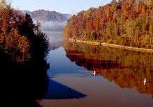
 Lake Cumberland as viewed at Wolf Creek Dam | |
| Location | Clinton, Laurel, McCreary, Pulaski, Russell, and Wayne Counties, Kentucky |
| Coordinates | 36°53′20″N 85°3′0″W / 36.88889°N 85.05000°W |
| Primary inflows | Cumberland River |
| Primary outflows | Cumberland River |
| Basin countries | United States |
| Surface area | 265.2 km2 (102.4 sq mi) (area at full pool) |
| Average depth | 27.4 metres (90 ft) |
| Max. depth | 60 metres (197 ft) |
| Surface elevation | 220 metres (722 ft) |
Lake Cumberland is a reservoir in Clinton, Laurel, McCreary, Pulaski, Russell, and Wayne counties in Kentucky.[1] The primary reasons for its construction were a means for flood control and the production of hydroelectric power. Its shoreline measures 1,255 miles (2,020 km) and the lake covers 65,530 acres (265 km2) at the maximum power pool elevation. The reservoir ranks 9th in the U.S. in size, with a capacity of 6,100,000 acre feet (7.5 km3) of water, enough to cover the entire Commonwealth of Kentucky with 3 inches (76 mm) of water. The main lake is 101 miles (163 km) long and over one mile (1.6 km) across at its widest point.
The lake has become a major source of tourism and an economic engine for south-central Kentucky. As of September 2011 Lake Cumberland was approximately 43 feet (13 m) below its normal level due to leakage in the earthen part of the dam, but repairs were completed in 2013 and officials estimated that lake levels would be back to normal by 2014-2015. As of 4-18-2015 the lake is back to full summer pool.
History
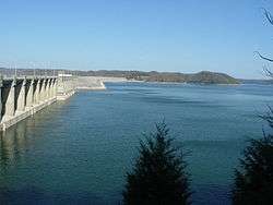
Lake Cumberland was impounded from the Cumberland River by the United States Army Corps of Engineers' construction of the Wolf Creek Dam in 1952.[1] Wolf Creek Dam is the 25th largest dam in the United States, and cost $15 million to construct originally, with an additional $65 million needed almost immediately to fix problems which soon became apparent. It is estimated that the dam has prevented more than $500 million in flood damage since its construction.
Dam repairs
In 1967 a leak was found at the Wolf Creek Dam. Repairs were made in the late seventies at a cost of over $96 million.
On January 22, 2007, the United States Army Corps of Engineers began lowering the water level in Lake Cumberland, fearing a possible breach in Wolf Creek Dam. Water seepage had eroded the limestone under the dam, creating the potential for a breach and subsequent flood that would cause damages into the billions of dollars in cities downstream .[2]
By September 2011 Lake Cumberland was approximately 43 feet (13 m) below its normal level. The drop in water level had a negative impact on the area's tourism industry as marinas and municipalities scrambled to adjust their facilities for the lower water level.[3] The caverns beneath the structure complicated plans for repairs, but a $594 million project to construct a new wall inside the dam was completed by early 2013 and tourism officials were anticipating higher visitation numbers as the lake level was raised to 705 feet.[3]
Since spring of 2014 Lake Cumberland water levels returned to normal operation and water levels. [4]
Uses
Power generation
Wolf Creek Dam's six turbines are capable of supplying the needs of an average city (population of 375,000) via 270 megawatts of electricity. The power generating capacity is considered "dead" when the lake's water level is below 673 feet (205 m).
Recreation
In 1999, approximately 4.75 million visitors added more than $152.4 million to the local economy. Of the 383 lakes controlled or maintained by the U.S. Army Corps of Engineers, Lake Cumberland ranks 4th in the nation for the number of visitor hours. Over 1,500 houseboats float on Lake Cumberland and numerous power boats play in its waters.
Lake Cumberland is home to two Kentucky state parks: Lake Cumberland State Resort Park on its shore and General Burnside State Park on an island in the middle of the lake.[1]
Several of Kentucky's record fish have been taken in the waters of Lake Cumberland,[5] including:
- Brown trout (21 lb)
- Lake trout (5 lb 5 oz)
- Rainbow trout (14 lb 6 oz)
- Sauger (7 lb 7 oz)
- Striped bass (58 lb 4 oz)
- Sturgeon (36 lb 8 oz)
- Walleye (21 lb 8 oz)
Statistics
| January | 48 °F | 9 °C |
| February | 44 °F | 7 °C |
| March | 48 °F | 9 °C |
| April | 55 °F | 13 °C |
| May | 66 °F | 19 °C |
| June | 76 °F | 24 °C |
| July | 82 °F | 28 °C |
| August | 84 °F | 29 °C |
| September | 79 °F | 26 °C |
| October | 70 °F | 21 °C |
| November | 58 °F | 14 °C |
| December | 51 °F | 11 °C |
- The normal summer pool is around 723 feet (220 m) above mean sea level.
- The tree line is about 725 feet (221 m).
- The maximum pool is 760 feet (232 m) at the top of dam floodgates
- The top of Wolf Creek Dam is 773 feet (236 m).
- Lake is considered at "flood control" level from 723 to 760 feet (220 to 232 m).
- Normal power drawdown is between 723 and 673 feet (220 to 205 m).
- At 760 feet (232 m) elevation, the shoreline of Lake Cumberland is 1,255 miles (2,020 km).
- At maximum possible elevation of 760 feet (232 m), Lake Cumberland is considered to be 101 miles (163 km) long, with a total surface area of 65,530 acres (265 km2).
- Surface area at 723 feet (220 m) is 50,250 acres (203 km2).
- At minimum power pool of 673 feet (205 m), the surface area is 35,820 acres (145 km2).
- Average depth of lake at summer pool of 723 feet (220 m) above sea level: 90 feet (27 m)
- Deepest point in lake: original river channel adjacent to Wolf Creek Dam: 200 feet (60 m)
- Depth of river channel upstream of dam to Wolf Creek: generally 160 feet (50 m)
- Depth of river channel upstream of Wolf Creek to one mile (2 km) downstream of Burnside: 280 feet
The lowest water level recorded (since construction) was 675.10 feet (205.77 m) above mean sea level on January 27, 1981. The highest water level recorded was 751.70 feet (229.12 m) above mean sea level at 2:00AM, May 13, 1984.
See also
References
- 1 2 3 Kleber, John E., ed. (1992). "Lakes". The Kentucky Encyclopedia. Associate editors: Thomas D. Clark, Lowell H. Harrison, and James C. Klotter. Lexington, Kentucky: The University Press of Kentucky. ISBN 0-8131-1772-0.
- ↑ Alford, Roger (2007-01-22). "Feds fear a dam break in Ky. and Tenn.". Associated Press. Archived from the original on 2007-01-24. Retrieved 2007-01-22.
- 1 2 Estep, Bill (2013-05-25). "With water level higher, optimism rises around Lake Cumberland". Lexington Herald-Leader. Retrieved 2013-05-25.
- ↑ U.S. Army Corp of Engineers, Nashville Division
- ↑ "Kentucky State Record Fish List". Kentucky Department of Fish and Wildlife Resources. 2006-04-17. Retrieved 2007-02-17.
External links
- Lake Cumberland Tourism Information
- Lake Cumberland Website
- Lake Cumberland State Parks
- Lake Cumberland Corps of Engineers