Lake Coeur d'Alene
| Lake Coeur d'Alene | |
|---|---|
 | |
| Location | Kootenai / Benewah counties, Idaho, U.S. |
| Coordinates | 47°32′00.46″N 116°48′32.84″W / 47.5334611°N 116.8091222°WCoordinates: 47°32′00.46″N 116°48′32.84″W / 47.5334611°N 116.8091222°W |
| Type | glacial, reservoir |
| Primary inflows |
Coeur d'Alene River, Saint Joe River |
| Primary outflows | Spokane River |
| Basin countries | United States |
| Max. length | 25 mi (40 km) |
| Max. width | 3 mi (4.8 km) |
| Surface area | 49.8 sq mi (129 km2) |
| Max. depth | 220 ft (67 m) |
| Water volume | 2,260,000 acre·ft (2.79 km3) |
| Residence time | 0.5 years |
| Surface elevation | 2,125 ft (648 m) |


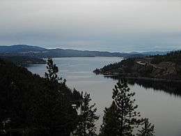
Lake Coeur d'Alene is a natural lake in northern Idaho, in the northwest United States. Its northern end is located in the city of Coeur d'Alene. It spans 25 miles (40 km) in length and ranges from 1 to 3 miles (5 km) wide with over 109 miles (175 km) of shoreline.
Geology and geography
Lake Coeur d'Alene, like other lakes surrounding the Spokane Valley and Rathdrum Prairie, was formed by the Missoula Floods, most recently 12,000 to 15,000 years ago. The Purcell Lobe of the Cordilleran Ice Sheet flowed south from Canada, carving the basin of present-day Lake Pend Oreille and damming the Clark Fork river. The impounded river repeatedly filled to form Glacial Lake Missoula and broke through the ice dam, resulting in massive floods that filled the Rathdrum Prairie area with sand, gravel, and boulders.[1] Large eddy bars formed downstream from bedrock obstructions, thereby damming tributary valleys and creating lakes. Lake Coeur d'Alene is fed primarily by two rivers, the Coeur d'Alene and the Saint Joe. The outflow is via the Spokane River.
The elevation of the lake varies from 2,128 feet (649 m) above sea level in the summer to up to 7 feet (2.1 m) lower in the winter, controlled by the Post Falls Dam 9 miles (14 km) below the lake on the Spokane River.[2]
The average surface temperature of the lake between June 1 and September 30 is 68 °F (20 °C).
History
The first-recorded European to see the area was explorer David Thompson in 1807. The lake has been used for transporting lumber by water in Kootenai County since the timber industry started in the region. Prior to a fire in 1917, Harrison was planned as the county seat of Kootenai County, as the swiftly growing lumber town was at an opportune junction of the St. Joe and Coeur d' Alene rivers. After the fire, the mills were moved mostly to the city of Coeur d'Alene, which developed more and was designated as the county seat.
A number of Ford Model T automobiles sitting on the bottom of the lake are the result of people in the early 1900s choosing to drive in winter across the frozen lake. But they did not always judge how thick the ice was, and went through. Steamboats on the bottom resulted from being burned and sunk as wrecks when they were no longer of use to ferry people around the lake. Since the late 20th century, divers frequently visit these ruins on the bottom as part of their recreation.
The Coeur d'Alene Tribe owns the southern third of Lake Coeur d'Alene and its submerged lands as part of its reservation, in addition to miles of the Saint Joe River and its submerged lands, all of which the United States holds in trust for the tribe. Its rights to the lake and river were established in the first executive order founding its reservation, which originally included all of the lake. In United States v. Idaho (2001),[3] the United States Supreme Court held that an 1873 executive order issued by President Ulysses S. Grant formalized ownership by the tribe.
While the court holding has not affected usage and access to Lake Coeur d'Alene, the Environmental Protection Agency has ruled that the tribe may set its own water-quality standards on its portion of Lake Coeur d'Alene.[4]
Recreation
Lake Coeur d'Alene is a popular tourist site for many people during the summer, offering great beaches and scenic views. A seasonal hobby of some local residents is viewing the bald eagles as they feed on the kokanee in the lake, mainly from the Wolf Lodge Bay. The North Idaho Centennial Trail, popular among cyclists, walkers, and joggers, follows along the lake's north and northeastern shore. The Trail of the Coeur d'Alenes also runs along the southern shores.
For a decade, the lake hosted unlimited hydroplane races for the Diamond Cup (1958–1966, 1968).[5][6][7][8][9]
Idaho State Parks and public facilities
- Coeur d'Alene Parkway State Park
- Heyburn State Park
- Trail of the Coeur d'Alenes
- Kootenai County Parks and Waterways Facilities Map
In popular culture
The song "Coeur d'Alene" by the rock band Alter Bridge from their third album AB III is about this lake.
See also
- Bunker Hill Mine and Smelting Complex
- Idaho v. Coeur d'Alene Tribe of Idaho (1997)
- Idaho v. United States (2001)
References
- ↑ Breckenridge, Roy M. (May 1993). Glacial Lake Missoula and the Spokane Floods (PDF) (Report). GeoNotes. 26. Idaho Geological Survey.
- ↑ "Post Falls Hydroelectric Development". Avista Utilities. Retrieved 2011-11-29.
- ↑ FindLaw for Legal Professionals - Case Law, Federal and State Resources, Forms, and Code
- ↑ "EPA says Coeur d'Alene Tribe can develop water quality standards", US Water News
- ↑ Boni, Bill (June 30, 1958). "Big Idaho race seen by 30,000". Spokesman-Review. Spokane, Washington. p. 1.
- ↑ "Hydroplane races draw many fans". Spokesman-Review. Spokane, Washington. (editorial). August 14, 1966. p. 4.
- ↑ "Diamond Cup go slated on Aug.11". Spokane Daily Chronicle. Washington. February 15, 1968. p. 25.
- ↑ "Coeur d'Alene announces Diamond Cup cancellation". Spokesman-Review. Spokane, Washington. April 29, 1969. p. 10.
- ↑ Johnson, Bob (February 12, 1972). "Diamond Cup race may be revived". Spokane Daily Chronicle. Washington. p. 10.
External links
| Wikimedia Commons has media related to Lake Coeur d'Alene. |
- MSR Maps - USGS topographical map and aerial photo
- Guide to Lake Coeur d'Alene
- State of Idaho Parks and Recreation website
- Parks and Waterways Facilities Map
- Current Lake Coeur d'Alene water temperature, elevation, and weather conditions.