Lake Abbe
| Lake Abbe | |
|---|---|
 satellite image | |
| Location | Ethiopia–Djibouti border |
| Coordinates | 11°10′N 41°47′E / 11.167°N 41.783°ECoordinates: 11°10′N 41°47′E / 11.167°N 41.783°E |
| Type | salt lake |
| Primary inflows | Awash River |
| Basin countries | Djibouti and Ethiopia |
| Surface area | 45,000 ha (170 sq mi) (34,000 ha open water, 11,000 ha salt flats) |
| Average depth | 36 metres (118 ft) |
| Surface elevation | 243 metres (797 ft) |
Lake Abbe, also known as Lake Abhe Bad, is a salt lake, lying on the Ethiopia-Djibouti border. It is one of a chain of six connected lakes, which also includes (from north to south) lakes Gargori, Laitali, Gummare, Bario and Afambo.[1]
Overview
Lake Abbe is the ultimate destination of the waters of the Awash River. It lies at the Afar Triple Junction, the central meeting place for the three pieces of the Earth's crust, a defining feature of the Afar Depression. Here three pieces of Earth’s crust are each pulling away from that central point, though not all at the same speed.[2]
On the northwest shore rises Mount Dama Ali (1069 m), a dormant volcano, while along the southwestern and southern shores extend vast salt flats, 10 km in width. Besides the Awash, seasonal affluents of Lake Abbe include two wadis, the Oleldere and Abuna Merekes, which enter the lake from the west and south, crossing the salt flats. Although the present area of the lake's open water is 34,000 hectares (130 sq mi), recent droughts and extraction of water from the Awash for irrigation has caused the water level of the lake to fall. By 1984, the surface area of the lake had decreased to two thirds of what it was in 1940. During this period about 11,500 hectares (28,000 acres) of saltflats had formed to the southwest of the lake.[3] Lake Abbe is a hypersaline lake; water containing mineral salts flows but there is no outflow, and pure water evaporates from the surface.[4] It is also known as an "amplifier lake", the water level fluctuating dramatically in response to quite small changes in climate.[5]
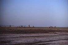
The Afar people have established a settlement near the lake's shore. Lake Abbe itself is known for its limestone chimneys, which reach heights of 50 m (160 ft) and from which steam spews forth.[6] Flamingos can also be found on the waters.[7]
References
- ↑ Robert Mepham, R. H. Hughes, and J. S. Hughes, A directory of African wetlands, (Cambridge: IUCN, UNEP and WCMC, 1992), p. 166
- ↑ Beyene, Alebachew & Abdelsalam, Mohamed G. (2005). "Tectonics of the Afar Depression: A review and synthesis". Journal of African Earth Sciences. 41 (1–2): 41–59. doi:10.1016/j.jafrearsci.2005.03.003.
- ↑ Hughes, R.H. (1992). A Directory of African Wetlands. IUCN. pp. 443–447. ISBN 978-2-88032-949-5.
- ↑ Hammer, U. T. (1986). Saline Lake Ecosystems of the World. Springer. p. 15. ISBN 90-6193-535-0.
- ↑ Michael Schagerl (2016). Soda Lakes of East Africa. Springer. p. 8. ISBN 978-3-319-28622-8.
- ↑ Michael Schagerl (2016). Soda Lakes of East Africa. Springer. p. 32. ISBN 978-3-319-28622-8.
- ↑ Nyla Jo Jones Hubbard (2011). Doctors Without Borders in Ethiopia: Among the Afar. Algora Publishing. p. 122. ISBN 978-0-87586-853-0.
External links
| Wikimedia Commons has media related to Lake Abbe. |
- (French) Photos of Lake Abbe
- ILEC database entry for Lake Abbe
- Lake Abbe
- Recent trip to Lake Abbe with photos (English)