Laizhou Bay
| Laizhou Bay | |
|---|---|
 | |
| Coordinates | 37°28′N 119°26′E / 37.47°N 119.43°ECoordinates: 37°28′N 119°26′E / 37.47°N 119.43°E |
| Type | Bay |
| River sources | Yellow River |
| Ocean/sea sources | Pacific Ocean |
| Basin countries | United States |
| Surface area | 7,000 km2 (2,700 sq mi) |
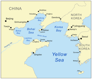
Laizhou Bay (simplified Chinese: 莱州湾; traditional Chinese: 萊州灣; pinyin: Láizhōu Wān) is the southern arm of the Bohai Sea (also known as the Bohai Gulf, or just Bo Hai), which is a large relatively shallow extension of Korea Bay (Northern Yellow Sea) behind the Liaodong Peninsula to the north, and the Shandong Peninsula to the south. Both peninsulas are roughly triangular in shape and point towards the Bohai Strait, the mouth opening out to the Yellow Sea via the southern region of Korea Bay.
References
- Tom McKnight,PhD, et al.; Geographica (ATLAS), 1999-2004, 3rd revision, Barnes and Noble Books AND Random House, New York, ISBN 0-7607-5974-X, 618 pp.
This article is issued from Wikipedia - version of the 9/24/2016. The text is available under the Creative Commons Attribution/Share Alike but additional terms may apply for the media files.