Ladysmith, KwaZulu-Natal
| Ladysmith Emnambithi | |
|---|---|
|
Ladysmith central business district | |
 Ladysmith  Ladysmith  Ladysmith
| |
| Coordinates: 28°33′35″S 29°46′50″E / 28.55972°S 29.78056°ECoordinates: 28°33′35″S 29°46′50″E / 28.55972°S 29.78056°E | |
| Country | South Africa |
| Province | KwaZulu-Natal |
| District | Uthukela |
| Municipality | Alfred Duma |
| Established | 1850[1] |
| Area[2] | |
| • Total | 84.13 km2 (32.48 sq mi) |
| Population (2011)[2] | |
| • Total | 64,855 |
| • Density | 770/km2 (2,000/sq mi) |
| Racial makeup (2011)[2] | |
| • Black African | 73.3% |
| • Coloured | 2.9% |
| • Indian/Asian | 15.0% |
| • White | 8.3% |
| • Other | 0.5% |
| First languages (2011)[2] | |
| • Zulu | 64.3% |
| • English | 22.8% |
| • Afrikaans | 6.3% |
| • Sotho | 2.2% |
| • Other | 4.5% |
| Postal code (street) | 3370 |
| PO box | 3370 |
| Area code | 036 |
| Website | ladysmith.kzn.org.za |

Ladysmith is a town in the Uthukela District of KwaZulu-Natal, South Africa. It is 230 kilometres (140 mi) north-west of Durban and 365 kilometres (227 mi) south of Johannesburg. Important industries in the area include food processing, textile and tyre production. Tyres are produced by Apollo Tyres in the nearby town of Steadville.
Ladysmith is the seat for both the Emnambithi-Ladysmith Local Municipality and the Uthukela District Municipality.
History

In 1847 after buying land from the Zulu king Mpande, a number of Boers settled in the area and called it the Republic of Klip River with Andries Spies as their commandant. The republic was annexed by the British in the same year and on 20 June 1850 was proclaimed a township called Windsor.[3] On 11 October 1850 the name was changed to Ladysmith after Juana María de los Dolores de León Smith also known as "Lady Smith," the Spanish wife of Sir Harry Smith, the Governor of the Cape Colony.[3] Sir Harry Smith was the British general governor of Cape Colony and high commissioner in South Africa from 1847 to 1852.[4]
A fort was built in 1860[3] to protect the villagers from the Zulu.
The Second Boer War
Battle of Ladysmith
During the Second Boer War British commander Lieutenant General Sir George White made Ladysmith his centre of operations for the protection of Natal against the Boer forces.[5] Starting on 29 October 1899 a number of short lived battles were fought for control of the town, but after suffering heavy casualties the British forces retreated to Ladysmith and the Boer forces did not make use of the opportunity to follow up the attack and take control of the town.
Siege of Ladysmith
Following the Battle of Ladysmith, whilst British forces under Lieutenant General Sir George White regrouped in the town, Boer forces surrounded Ladysmith. The siege lasted 118 days, from 2 November 1899 to 28 February 1900, during the most crucial stage of the war.[6] Approximately 3,000 British soldiers died during the siege.
Relief of Ladysmith
Three attempts by General Sir Redvers Buller to break the siege resulted in defeat for the British forces at the battles of Colenso, Spion Kop and Vaal Krantz. On 6 January 1900 the Boer forces of Commandant-General Piet Joubert attempted to end the siege by taking the town before the British could launch another attempt to break the siege. This led to the battle of Platrand (or Wagon Hill) south of the town.
Buller finally broke the siege on 28 February 1900 after defeating the Boers by using close cooperation between his infantry and artillery.
Sir Winston Churchill, then a young war correspondent for The Morning Post (London), was present at the Relief of Ladysmith after having been taken prisoner (between Ladysmith and Colenso) and escaping earlier during the war.[7][8][9]
Mohandas Gandhi and the stretcher-bearing corps that he established earlier during the war was involved in a number of actions that took place in and around Ladysmith during the Relief.[10]
Military units involved in the Siege and Relief of Ladysmith
Geography

Ladysmith is located on the banks of the Klip River ("stone river"), with the central business district and a large part of the residential areas located within the flood basin of the river. It is on the foothills of the Drakensberg mountains, about 26 km from the Van Reenen pass.
Flooding
Since it was established the town has suffered severely from flooding of the Klip River. During the 110 years up to 1997 with the completion of the Qedusizi Dam,[11] 29 serious floods have occurred.[12] Minor flooding occurred almost every year.
The worst flooding in 30 years occurred in 1996 leading to R500 million in damages and the evacuation of 400 families.[13]
Efforts to control the flooding date back to the 1940s. In 1949 the Windsor Dam was completed, but this dam silted up very fast and was not an effective means of flood control.[12]
Climate
Ladysmith has a subtropical highland climate (Cwb, according to the Köppen climate classification), with warm summers and cool, dry winters. It borders on a humid subtropical climate (Cwa). The average annual precipitation is 639 mm (25 in), with most rainfall occurring during summer.
| Ladysmith | ||||||||||||||||||||||||||||||||||||||||||||||||||||||||||||
|---|---|---|---|---|---|---|---|---|---|---|---|---|---|---|---|---|---|---|---|---|---|---|---|---|---|---|---|---|---|---|---|---|---|---|---|---|---|---|---|---|---|---|---|---|---|---|---|---|---|---|---|---|---|---|---|---|---|---|---|---|
| Climate chart (explanation) | ||||||||||||||||||||||||||||||||||||||||||||||||||||||||||||
| ||||||||||||||||||||||||||||||||||||||||||||||||||||||||||||
| ||||||||||||||||||||||||||||||||||||||||||||||||||||||||||||
Cityscape
Architecture

The Soofi Mosque on the banks of the Klip River was originally built sometime between 1895 and 1910, but it was greatly extended in the 1960s.[14][15]
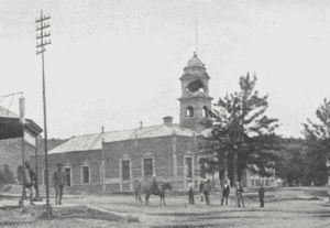
Other building of interest are the Siege Museum, originally built in 1884 as a marketplace[16] and the Town Hall, damaged by Boer artillery during the Second Boer War.
Transport
Air
Ladysmith is served by a small airport, (IATA: LAY, ICAO: FALY) is located on the outskirts of town just below Platrand at 28°34′48″S 29°45′10″E / 28.58000°S 29.75278°E. The Aerodrome is managed and operated by JetVision Holdings Pty Ltd.
Rail

The Danskraal Yard is located on the Free State main line and the Glencoe–Vryheid line and acts as a depot for train marshalling and maintenance as well as rail maintenance.[17]
The passenger station is located some distance away from Danskraal close to the Central Business District.
Road
The N11 links Ladysmith with Bergville and Newcastle, while the R103 provides access to Colenso, KwaZulu-Natal and the N3.
Traffic traveling between Durban and Johannesburg used to pass through Ladysmith up until the late 1980s, but the completion of the N3, bypassing Ladysmith 15 kilometres (9.3 mi) to the west, has caused a dramatic drop in traffic volumes through this town as well as others that are now bypassed.[18]
Education
Primary
- Acaciavale Primary School
- Aloe Park Primary School.
- Andante Independent School
- Egerton
- Hamilton Preparatory School
- Islamic Educational Centre
- Keate Street Primary School
- Limit Hill Combined
- MC Varman Primary School
- Baldaskraal Primary School
- ML Sultan
- Mnambithi Primary
- Monument Primary School
- Nikela Primary School
- Umbulwane Primary
- Blue Bank primary
- Kirkintulloch Combined school
- Peace Town Combined School
- Hursley Primary School
- Incwaba Junior Primary School
- Insungulu Lower Primary School
- Burford Primary School
Secondary
- Emhlwaneni High School
- Klipriver High School
- Ekukhuleni High School
- Harvest High School
- Islamic Educational Centre
- Ladysmith High School (LHS)
- Ladysmith Secondary (LASEC)
- Limit Hill Combined
- Hlope Secondary
- Tatane Secondary
- Sakhelwe High School
- Windsor Secondary School
- Mhlwaneni high school
- Qophindlela Secondary
- uxolo nokuzwana secondary
- Sicelokuhle High School
- ingula High School
- Phayikeni High School
- Intababusuku Secondary
- Indakane High School
- Entonjeni High School *Ndalela High School
- Steadville High School
- Bhekintuthuko Secondary School
- Ndalela High School
Special schools
- Inkanyezi Special School
Tertiary
- Boston City Campus
- Mnambithi FET College is a public college offering Further Education & Training.
- Qualitas Career Academy, caters for full-time and part-time studies for students as well as corporate training and consulting services for businesses and government departments. There are a variety of academic divisions.
- Ladysmith University of Technology (LUTech)
Society and culture
Media
The only sold local newspaper in Ladysmith is the Ladysmith Gazette. The Ladysmith Gazette is just over a century old, and is believed to have been established in 1902. The Ladysmith Gazette is part of the Caxton Group of newspapers. One of two free local newspapers is the Ladysmith Herald.[19] The other free newspaper is the Times of Ladysmith.
Museums, monuments and memorials
The Second Boer War
A large number of the Second Boer War Battlefields around Ladysmith have been preserved as memorial sites. Monuments and memorials to those who died during the battles have been erected at most of them.
Siege museum
Located next to the town hall there is a small museum detailing the battles and history at the time of the Siege. The museum was opened in 1985 and holds around 60,000 documents related to the Siege and Boer War.[20]

Platrand/Wagon Hill

 Media related to Platrand Memorials at Wikimedia Commons
Located just south of the town, this area saw action during the Relief of Ladysmith. The Burgher Memorial on Wagon Hill was erected in honour of Boer forces killed during the siege and relief of Ladysmith.[21]
On Platrand there are memorials to the Imperial Light Horse, the Devonshire Regiment, the Earl of Ava and a number of others.
Castor and Pollux

Two RML 6.3 inch Howitzers used by the British during the Siege stand in front of the Town Hall.
Mohandas Gandhi statue
A statue of Mohandas Gandhi can be seen at the Lord Vishnu Temple.
Music
Ladysmith is the hometown of Joseph Shabalala, founder of the group Ladysmith Black Mambazo.[22]
Sport
Thulani "Sugar Boy" Malinga, a champion boxer was born in Ladysmith.[23]
Elmer Symons, Dakar Rally rider who was killed in the 2007 edition while leading the Marathon class.
Military
5 South African Infantry Battalion is based in Ladysmith.[24] A military shooting range is located on the outskirts of the town between the Aerodrome and Platrand.
Famous people
- Menzi Ngubane- Generations Actor
- André Joubert - Rugby union player
- Thulani "Sugarboy" Malinga - Boxer and WBC middleweight champion
See also
| Wikimedia Commons has media related to Ladysmith, KwaZulu-Natal. |
Bibliography
- Hewetson, George Benson (1908). "Ladysmith". The mountains and other poems. London: Sisley's. Retrieved 2009-11-10.
- Ladysmith — a novel by Giles Foden that is set in Ladysmith
- London to Ladysmith via Pretoria — a book by Winston Churchill that includes an account of the Relief of Ladysmith
- Gore, St. John (1901). The Green Horse in Ladysmith. Sampson, Low, Marston and Co. Available as The Green Horse in Ladysmith on the Internet Archive
- Donald, MacDonald (1900). How We Kept the Flag Flying: The Story of the Siege of Ladysmith. Ward, Lock & Co. Available as How We Kept the Flag Flying: The Story of the Siege of Ladysmith on the Internet Archive
- Steevens, George Warrington. From Capetown to Ladysmith: An Unfinished Account of the South African War. available as
- From Capetown to Ladysmith by George Warrington Steevens at Project Gutenberg
- Norris, Stephen Leslie (1900). The South African War, 1899-1900 : a military retrospect up to the relief of Ladysmith. John Murray. Available as The South African War, 1899-1900 : a military retrospect up to the relief of Ladysmith on the Internet Archive
- Wilkinson, Spenser (1900). Lessons of the War: Being Comments from Week to Week, to the Relief of Ladysmith. Constable. Available as Lessons of the War: Being Comments from Week to Week, to the Relief of Ladysmith on the Internet Archive
- Atkins, John Black (1900). The relief of Ladysmith. Methuen. Available as The relief of Ladysmith on the Internet Archive
- The Collected Works of Mahatma Gandhi — contains a number of chapters dealing with Ladysmith:
- Volume II - Indians in Ladysmith (29-10-1903); Indian Store-Keepers in Ladysmith (5-11-1903); Indian Licences in Ladysmith (10-12-1903)
- Volume IV - Ladysmith Licences (11-2-1904)
- Volume V - The Ladysmith Licensing Board (21-4-1906); Indentured Indians in Ladysmith (23-6-1906)
- Volume VI - Ladysmith Licences (23-2-1907); Ladysmith Appeals (20-4-1907); Licence Case in Ladysmith (11-5-1907); Ladysmith Struggle (18-5-1907)
- Volume VII - The Ladysmith Traders (31-8-1907); Licences in Ladysmith (31-8-1907); Indian Merchants of Ladysmith (26-10-1907)
References
- ↑ "Chronological order of town establishment in South Africa based on Floyd (1960:20-26)" (PDF). pp. xlv–lii.
- 1 2 3 4 "Main Place Ladysmith". Census 2011.
- 1 2 3 "Ladysmith History & The Boer War". Retrieved 2008-10-21.
- ↑ Smith, Harry (1903). "The Autobiography of Lieutenant-General Sir Harry Smith". Retrieved 2008-10-21.
- ↑ Durand, Henry Mortimer; White, George Stuart (1915). "III - Arrival in South Africa". The life of Field-Marshal Sir George White, V.C. Volume II. Edinburgh, London: W. Blackwood. pp. 17–27. Retrieved 2009-12-01.
- ↑ Rickard, J (2007-02-05). "Siege of Ladysmith, 2 November 1899 – 27 February 1900". Retrieved 2008-10-21.
- ↑ Creswicke, Louis. "From the Commencement of the War to the Battle of Colenso, 15th Dec. 1899". South Africa and the Transvaal War, Vol. 2 (of 6). Project Gutenberg. Retrieved 2008-09-08.
- ↑ "Winston Churchill". bbc.co.uk. Retrieved 3 February 2008.
- ↑ "Churchill, Sir Winston". Encyclopædia Britannica Online. Retrieved 3 February 2008.
- ↑ Radhakrishnan, S. (2000). Mahatma Gandhi: Essays and Reflections. Jaico Publishing House. p. 510. ISBN 978-81-7224-122-3.
- ↑ "Water resource management". South African Government Information. 1998. Retrieved 2008-09-08.
- 1 2 "The problem of flooding in Ladysmith, Natal, South Africa". Engineering Geology Special Publications. Geological Society, London. 1998. Retrieved 2008-09-08.
- ↑ "Disaster management guidelines for municipalities". National Disaster Management Centre. p. 10. Archived from the original (PDF) on February 22, 2014. Retrieved 2008-10-21.
- ↑ "Soofi Mosque". Amafa / Heritage KwaZulu Natal. Pietermaritzburg, KwaZulu-Natal, South Africa: Heritage KwaZulu Natal. Retrieved 18 February 2012. External link in
|work=(help) - ↑ Browne, James Stark (1906). "The Battlefields". Through South Africa with the British Association. London: J Speirs. p. 73.
- ↑ "The Siege Museum". Tourism Natal.net. Retrieved 2008-10-22.
- ↑ "KwaZulu-Natal Freight Transport Data bank". KwaZulu-Natal Department of Transport. Retrieved 2008-10-21.
- ↑ "Heritage Impact Assessment of Braamhoek Integrated Power Supply Project" (PDF). eThembeni Cultural Heritage. p. 8. Retrieved 2010-06-20.
- ↑ http://epaper.ladysmithherald.co.za
- ↑ "52. Ladysmith Siege Museum". National Archives and Records Service (NARS). Retrieved 2008-10-22.
- ↑ "Platrand & Burger Memorial". Heritage KwaZulu Natal. Retrieved 1 December 2009.
- ↑ "The Ofical site of Ladysmith Black Mambazo". Ladysmith Black Mambazo. 2010. Retrieved 28 January 2013.
- ↑ "Thulane MALINGA". Boxing Records Online. Retrieved 2008-10-21.
- ↑ "Infantry Formation". South African Army. Retrieved 2008-10-21.
External links
| Wikivoyage has a travel guide for Ladysmith. |
Municipalities and communities of UThukela District Municipality, KwaZulu-Natal | ||
|---|---|---|
District seat: Ladysmith | ||
| Alfred Duma | .svg.png) | |
| Inkosi Langalibalele | ||
| Okhahlamba | ||