Lackawaxen River
| Lackawaxen | |
| River | |
 The Lackawaxen River several miles above confluence with the Delaware | |
| Country | United States |
|---|---|
| State | Pennsylvania |
| Region | Poconos |
| Counties | Wayne, Pike |
| Tributaries | |
| - right | Wallenpaupack Creek |
| Landmark | Prompton Lake |
| Primary source | West Branch Lackawaxen River |
| - location | Confluence above Belmont Lake, in Orson and Poyntelle |
| - elevation | 1,840 ft (561 m) |
| - coordinates | 41°47′31″N 75°25′54″W / 41.79194°N 75.43167°W |
| Secondary source | Johnson Creek |
| - location | Mt. Pleasant Twp. |
| - elevation | 1,480 ft (451 m) |
| - coordinates | 41°44′45″N 75°23′1″W / 41.74583°N 75.38361°W |
| Source confluence | E of PA 170 |
| - location | Creamtown |
| - elevation | 1,250 ft (381 m) |
| - coordinates | 41°40′40″N 75°22′44″W / 41.67778°N 75.37889°W |
| Mouth | Delaware River |
| - location | Lackawaxen |
| - elevation | 580 ft (177 m) |
| - coordinates | 41°29′13″N 74°59′14″W / 41.48694°N 74.98722°WCoordinates: 41°29′13″N 74°59′14″W / 41.48694°N 74.98722°W |
| Length | 31 mi (50 km) |
| Basin | 598 sq mi (1,549 km2) |
| Discharge | for Rowland |
| - average | 1,318 cu ft/s (37 m3/s) |
| - max | 13,208 cu ft/s (374 m3/s) |
| - min | 53 cu ft/s (2 m3/s) |
| Discharge elsewhere (average) | |
| - Honesdale | 394 cu ft/s (11 m3/s) |
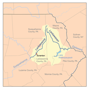 Map of Lackawaxen and Lackawanna watersheds | |
| Discharge figures from "Water data for Lackawaxen River at Howland, 2008" (PDF). United States Geological Survey. Retrieved November 20, 2009. and | |
The Lackawaxen River is a 31.3-mile-long (50.4 km)[1] tributary of the Delaware River in northeastern Pennsylvania in the United States. The river flows through a largely rural area in the northern Pocono Mountains, draining an area of approximately 598 square miles (1,550 km2).
Its source is in the borough of Prompton in western Wayne County, at the confluence of the West Branch and Van Auken Creek. It flows past Honesdale and Hawley, where it is joined from the southwest by Wallenpaupack Creek. It continues east and joins the Delaware at Lackawaxen. East of Honesdale, it was deepened as part of the Delaware and Hudson Canal project.
The river is a popular destination for canoeing and recreational fly fishing for trout. It was reportedly where the American author Zane Grey first learned to fly fish.[2]
West Branch Lackawaxen River
The West Branch, approximately 21.5 miles (34.6 km) long,[1] rises from a confluence of several small streams in the villages of Orson and Poyntelle in northern Wayne County, and flows south-southeast through Belmont Lake in Belmont Corners. After a second confluence, with Johnson Creek, it flows southeast through Prompton Lake reservoir, to a third confluence, with Van Auken Creek, to form the main stem.[3]
See also
References
- 1 2 U.S. Geological Survey. National Hydrography Dataset high-resolution flowline data. The National Map, accessed April 1, 2011
- ↑ Lackawaxen River Conservatory Website
- ↑ Gertler, Edward. Keystone Canoeing, Seneca Press, 2004. ISBN 0-9749692-0-6
External links
- Lackawaxen River Conservancy
- Pike County Conservation: Lackawaxen watershed
- Lackawaxen Aqueduct
- U.S. Geological Survey: PA stream gaging stations