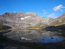
Lac de Salanfe
| Lac de Salanfe | |
|---|---|
 | |
| Location | Valais |
| Coordinates | 46°8′21″N 6°57′17″E / 46.13917°N 6.95472°ECoordinates: 46°8′21″N 6°57′17″E / 46.13917°N 6.95472°E |
| Catchment area | 18.4 km2 (7.1 sq mi) |
| Basin countries | Switzerland |
| Max. length | 2 km (1.2 mi) |
| Surface area | 1.62 km2 (0.63 sq mi) |
| Max. depth | 48 m (157 ft) |
| Surface elevation | 1,925 m (6,316 ft) |
Lac de Salanfe is a lake in the municipality of Evionnaz, Valais, Switzerland. The reservoir is located at an elevation of 1925 m. Its surface area is 1.62 km2 (0.63 sq mi).
It can be reached by 6.5 km-long foot path from Vernayaz.
The dam Salanfe was completed in 1952.
Different major walking trails cross in Salanfe. The two biggest are 'Le tour des Dents du Midi' and the Via Alpina. Many hikers stay the night at the refuge situated next to the lake.[1]
References
- ↑ Auberge de Salanfe, Website of the refuge Salanfe.
External links
![]() Media related to Lac de Salanfe at Wikimedia Commons
Media related to Lac de Salanfe at Wikimedia Commons
This article is issued from Wikipedia - version of the 9/4/2015. The text is available under the Creative Commons Attribution/Share Alike but additional terms may apply for the media files.