La Vernia, Texas
| La Vernia, Texas | |
|---|---|
| City | |
 | |
| Nickname(s): L V, Bear Country | |
| Motto: This is Bear Country | |
 Location of La Vernia, Texas | |
 | |
| Coordinates: 29°21′19″N 98°7′5″W / 29.35528°N 98.11806°WCoordinates: 29°21′19″N 98°7′5″W / 29.35528°N 98.11806°W | |
| Country | United States |
| State | Texas |
| County | Wilson |
| Area | |
| • Total | 1.9 sq mi (5.0 km2) |
| • Land | 1.9 sq mi (5.0 km2) |
| • Water | 0.0 sq mi (0.0 km2) |
| Elevation | 489 ft (149 m) |
| Population (2000) | |
| • Total | 1,034 |
| • Density | 482.8/sq mi (186.4/km2) |
| Time zone | Central (CST) (UTC-6) |
| • Summer (DST) | CDT (UTC-5) |
| ZIP code | 78121 |
| Area code(s) | 830 |
| FIPS code | 48-41764[1] |
| GNIS feature ID | 1360813[2] |
| Website | lavernia-tx.gov |
La Vernia is a city in Wilson County, Texas, United States. It is located is on the south bank of Cibolo Creek at the junction of U.S. Highway 87 and Texas Farm to Market Road 775, fifteen miles north of Floresville in northern Wilson County.[3] The population was 1,034 in the 2010 census.[4] It is part of the San Antonio Metropolitan Statistical Area.
History
The area known as present-day La Vernia was first inhabited by indigenous American Indians of the Coahuiltecan speaking peoples of Texas and subsequently by nomadic bands of Apache and Comanche who migrated to Texas in the 17th century. One of the earliest land grants made was to Erastus "Deaf" Smith, also known as Deaf Smith. Deaf Smith married Guadalupe Ruiz Durán, a Mexican citizen who was descended from one of the original Tejano or Spanish Texas families;[5] and as such, received a land grant from the Mexican government on the Cibolo River, north of present-day La Vernia in 1825. This area remained primarily unsettled by Europeans until 1837, when veterans from the recent wars of Independence from Mexico began to arrive.
La Vernia was firs settled in earnest around 1850. W. R. Wiseman of Mississippi, who organized a Presbyterian church at the site around 1851, is said to have named the place Live Oak Grove, for a grove of trees nearby.[6]
In 1853 a post office was established under the name Post Oak, which was changed to La Vernia in 1859. H. Suhre, owner of the general store, was the first postmaster.[3] The origin of the name is uncertain. Although, in 1853 William Claiborne Rector was the postmaster at the local post office and during this time the town was still called Post Oak.[7]
The town's current name came from the local Spanish vernacular for "green oaks", or "La Vernia“. Hence, the Brahan Masonic lodge was first established at "La Vernia" in 1859. The building also served as a school and church.[8]
German and Polish immigration brought the population to 110 by 1885. The community was now served by three churches, a steam gristmill, and a cotton gin. H. Suhre was the owner of the general store.[6] During this time the major crop grown was corn, being it was so universally useful. Cotton also proved to be an important commodity. In present-day La Vernia, corn and cotton are still major crops.
In 1890, La Vernia had a population of 200. Construction of the San Antonio and Gulf Railroad across the area in 1893 brought the population to 343 by 1900. A two-teacher school was in operation by 1896. Classes grew to be so large, that they had to move out of the Masonic lodge. The enrollment had grown to sixty-six children.[6]
By 1915, the town operated two gins, a bank, four churches, a pottery plant, a brick works, and supported a population of 500. In 1947, seventeen businesses would provide much attraction, to more and more people, over the coming years. In 1965, population had increased to 700 residents and twenty-five businesses.[6]
The community incorporated around 1966, and in 1990, had a population of 639 and thirty-six businesses and a gas station called "Tommy's Exxon", owned by Bonnie and Thomas Kravitz, and assisted by their son, Samuel Kravitz. La Vernia experienced out-migration and a subsequent population drop, due to the lure of the big city atmosphere and larger job markets available in neighboring San Antonio, Floresville and Canyon Lake. Many larger towns were getting very popular about this time.
In 2000, La Vernia had 136 businesses and a population of 931. The census[1] of 2005 La Vernia had a population of 1,087 of people. In 2010 a new shopping area was built just west of town on Hwy 87, including a new H-E-B grocery store and gas station. A longtime grocer, Baumann's Grocery store, closed at the time HEB opened.
Geography
La Vernia is located at 29°21′19″N 98°7′5″W / 29.35528°N 98.11806°W (29.355187, -98.118122).[9] It is just about 30 minutes south-east of Downtown San Antonio. La Vernia is 489 feet (149 m) above sea level. According to the United States Census Bureau, the city has a total area of 1.9 square miles (5.0 km²), all of it land. latest census[1] of 2005 the population of La Vernia is 1,087 people.
Climate
In San Antonio, July and August tend to be the warmest months with an average high of 95 degrees Fahrenheit (35 °C). The highest temperature ever to be recorded was 111 °F (43.8 °C) on September 5, 2000.[10] The average coolest month is January. The lowest recorded temperature ever was 0 °F (-17.7 °C) on January 31, 1949. May, June, and October have quite a bit of precipitation. For the last 135 years, the average annual precipitation has been 29.05 inches (73.79 cm), with a maximum of 52.28 inches (132.79 cm) and a minimum of 10.11 inches (25.68 cm) in one year.[11]
| Climate data for San Antonio (San Antonio Int'l), 1981–2010 normals, extremes 1885–present[lower-alpha 1] | |||||||||||||
|---|---|---|---|---|---|---|---|---|---|---|---|---|---|
| Month | Jan | Feb | Mar | Apr | May | Jun | Jul | Aug | Sep | Oct | Nov | Dec | Year |
| Record high °F (°C) | 89 (32) |
100 (38) |
100 (38) |
101 (38) |
104 (40) |
107 (42) |
106 (41) |
110 (43) |
111 (44) |
99 (37) |
94 (34) |
90 (32) |
111 (44) |
| Average high °F (°C) | 62.9 (17.2) |
66.9 (19.4) |
73.5 (23.1) |
80.5 (26.9) |
87.0 (30.6) |
92.3 (33.5) |
94.6 (34.8) |
96.0 (35.6) |
90.3 (32.4) |
82.2 (27.9) |
72.2 (22.3) |
64.0 (17.8) |
80.2 (26.8) |
| Average low °F (°C) | 40.7 (4.8) |
44.2 (6.8) |
50.8 (10.4) |
58.1 (14.5) |
66.8 (19.3) |
72.6 (22.6) |
74.6 (23.7) |
74.7 (23.7) |
69.1 (20.6) |
60.1 (15.6) |
50.1 (10.1) |
41.7 (5.4) |
58.6 (14.8) |
| Record low °F (°C) | 0 (−18) |
4 (−16) |
19 (−7) |
31 (−1) |
42 (6) |
48 (9) |
60 (16) |
57 (14) |
41 (5) |
27 (−3) |
21 (−6) |
6 (−14) |
0 (−18) |
| Average precipitation inches (mm) | 1.76 (44.7) |
1.79 (45.5) |
2.31 (58.7) |
2.10 (53.3) |
4.01 (101.9) |
4.14 (105.2) |
2.74 (69.6) |
2.09 (53.1) |
3.03 (77) |
4.11 (104.4) |
2.28 (57.9) |
1.91 (48.5) |
32.27 (819.8) |
| Average snowfall inches (cm) | 0.7 (1.8) |
trace | 0 (0) |
0 (0) |
0 (0) |
0 (0) |
0 (0) |
0 (0) |
0 (0) |
0 (0) |
0 (0) |
0 (0) |
0.7 (1.8) |
| Average precipitation days (≥ 0.01 in) | 7.0 | 7.2 | 8.8 | 6.4 | 8.5 | 7.5 | 5.2 | 4.7 | 6.6 | 6.9 | 6.7 | 7.5 | 83.0 |
| Average snowy days (≥ 0.1 in) | 0.2 | 0.2 | 0 | 0 | 0 | 0 | 0 | 0 | 0 | 0 | 0 | 0 | 0.4 |
| Average relative humidity (%) | 67.1 | 65.2 | 63.2 | 66.3 | 70.5 | 68.8 | 65.0 | 64.7 | 68.0 | 67.2 | 68.3 | 68.0 | 66.9 |
| Mean monthly sunshine hours | 159.4 | 169.7 | 215.5 | 209.7 | 221.8 | 275.9 | 308.8 | 293.9 | 234.9 | 218.0 | 171.9 | 149.7 | 2,629.2 |
| Percent possible sunshine | 49 | 54 | 58 | 54 | 52 | 66 | 72 | 72 | 63 | 61 | 54 | 47 | 59 |
| Source: NOAA (relative humidity and sun 1961–1990),[12][13][14] The Weather Channel[15] | |||||||||||||
- ↑ Official records for San Antonio were kept at downtown from March 1885 to December 1940, at Stinson Municipal Airport from January 1941 to June 1942, and at San Antonio Int'l since July 1942. For more information, see Threadex
Demographics
| Historical population | |||
|---|---|---|---|
| Census | Pop. | %± | |
| 1970 | 425 | — | |
| 1980 | 632 | 48.7% | |
| 1990 | 639 | 1.1% | |
| 2000 | 931 | 45.7% | |
| 2010 | 1,034 | 11.1% | |
| Est. 2015 | 1,261 | [16] | 22.0% |
| U.S. Decennial Census | |||
As of the census[1] of 2000, there were 931 people, 317 households, and 239 families residing in the city. The population density was 482.8 people per square mile (186.2/km²). There were 344 housing units at an average density of 178.4 per square mile (68.8/km²). The racial makeup of the city was 92.48% White, 0.11% African American, 0.75% Native American, 0.64% Asian, 4.19% from other races, and 1.83% from two or more races. Hispanic or Latino of any race were 19.98% of the population.
There were 317 households out of which 40.1% had children under the age of 18 living with them, 57.4% were married couples living together, 15.5% had a female householder with no husband present, and 24.6% were non-families. 21.1% of all households were made up of individuals and 12.0% had someone living alone who was 65 years of age or older. The average household size was 2.65 and the average family size was 3.08.
In the city the population was spread out with 25.1% under the age of 18, 7.1% from 18 to 24, 27.2% from 25 to 44, 17.1% from 45 to 64, and 23.5% who were 65 years of age or older. The median age was 40 years. For every 100 females there were 81.8 males. For every 100 females age 18 and over, there were 72.5 males.
The median income for a household in the city was $38,500, and the median income for a family was $46,912. Males had a median income of $35,625 versus $24,844 for females. The per capita income for the city was $19,931. About 12.5% of families and 12.3% of the population were below the poverty line, including 18.1% of those under age 18 and 12.6% of those age 65 or over.
La Vernia has a lower crime rate compared to surrounding towns.[17] Statistics presented are based on data collected by the FBI as part of its Uniform Crime Reporting Program. These data represent offenses reported to and arrests made by State and local law enforcement agencies as reported to the FBI. Total 347, Murder is 2, Rape are 3, Robbery is 0, Aggravated Assault has recorded 38, Burglary 70, Larceny - theft is unusually high at 228, Motor vehicle thefts is at 6, and Coverage indicator is 100%.[18]
Economy and recreation
La Vernia is a thriving rural community located on State Highway 87, 25 miles east of San Antonio, Texas. La Vernia is in the rich oil and gas play known as the Eagle Ford Shale.
National food chains include: Dairy Queen, Golden Chick, Pizza Hut, Sonic, Subway, Taco Bell, and Whataburger. Family-owned restaurants include: the Bluebonnet, Buffalo Joes, Caparelli's Italian Restaurant, La Vernia Chinese Cuisine, Mr. Tim's Country Kitchen, Taste of Chicago, Witte's Bar-B-Que, and The Den . Mexican cuisine can be found at Sammy's, Busy Bear, Big Tejas, Los Compadres, and Alondra's. Groceries are available at HEB and Dollar General. Specialty foods can be found at Simply Sweet, and Donut Palace.
Farm and ranch supplies and western wear can be purchased at the La Vernia Country Store. Hardware is available at the Big Bear Home Center and The Mill. La Vernia is home to Koepp Chevrolet, a full-service automobile dealership. Napa Auto Parts is the community's source for automobile parts. Appliances and cooking supplies can be purchased at GVEC Home Services and Smith Propane. Music supplies, band instrument rental and music lessons are available at the Music Loft. Computer and cell phone repair are available at the Computer Loft.
Manufacturers in La Vernia include: Kayco Spray Booths, Aire Plastics, Red Apple Industries, and Leather King. Oil and gas service companies serving the Eagle Ford Shale include: D&D Power Systems, Old School Services, Coastal Flow, VZ Environmental and Connect Transport.
Doctor's offices and urgent care clinics include: Connally Memorial Urgent Care & Health Center and the Urgent Care Clinic of La Vernia.
The La Vernia Heritage Museum displays artifacts and memorabilia relating to the history and development of the city.[19]
Education
La Vernia Independent School District () provides public education to the students of La Vernia. The overall student body is in the range of 3-4 thousand students. This is roughly 4 times the population of the city itself. La Vernia Primary School includes grades Pre-K through 3rd grade. The newly constructed Intermediate School, opened in 2009, includes grades 3-5. The building that now serves as the Junior High was the first school building built for the La Vernia school district. Originally serving all grades, it now houses the 6th, 7th and 8th grades. The La Vernia High School consists of grades 9-12.
Private school education is also provided at the La Vernia Christian Teaching Center ().
Older schools served the La Vernia area prior to the start of the La Vernia Independent School District. The Masonic Lodge (mentioned above) served to educate students for many years. Other early schools includes the Concrete School, which has a marker to show its original location on Country Road 539. Another early school was known as Hill Top School, which was an old two room school house. It was later sold to Lowell and Dorris Jones who turned it into a farmhouse where they raised their family. The home is no longer owed by the Jones family but is a residence in La Vernia.
Sports
The town of La Vernia has many different youth sports teams. The La Vernia Grizzlies Youth Sports Association is a TYFA (Texas Youth Football Association) affiliated organization with facilities at Wiseman Field off FM 775. Grizzlies flag football and tackle football teams are open for children ages 4–13. Grizzlies cheerleaders can participate from ages 3–13. Also St Ann’s C.Y.O has sports for kids such as soccer, volleyball, flag football, track, basketball, baseball, and softball. You are able to start at the age of four years. Junior High has quite a few different teams for grades 7 and 8, including girls' volleyball, basketball, tennis, cross-country, and track, and boys' football, basketball, tennis, cross-country, and track. start the sports when you enter the seventh grade and end the junior high sports when you end the eighth grade. High school sports girls' sports are volleyball, basketball, softball, tennis, cross-country, Dance Team, power lifting, and track. Boys' sports are football, power lifting, lacrosse, basketball, baseball, tennis, cross-country, soccer, and track.
Notable people
- Dusty Jonas, Olympic high jumper
- Austin Mahone, pop singer
References
- 1 2 3 4 "American FactFinder". United States Census Bureau. Retrieved 2008-01-31.
- ↑ "US Board on Geographic Names". United States Geological Survey. 2007-10-25. Retrieved 2008-01-31.
- 1 2 CLAUDIA, HAZLEWOOD, (2010-06-15). "LA VERNIA, TX". tshaonline.org. Retrieved 2016-10-24.
- ↑ "La Vernia (Lavernia), TX Population - Census 2010 and 2000 Interactive Map, Demographics, Statistics, Quick Facts - CensusViewer". censusviewer.com. Retrieved 2016-10-24.
- ↑ http://www.tamu.edu/faculty/ccbn/dewitt/adp/history/bios/e_smith/e_smith.html
- 1 2 3 4 Claudia Hazlewood, "LA VERNIA, TX," Handbook of Texas Online (http://www.tshaonline.org/handbook/online/articles/hll04), accessed May 31, 2011. Published by the Texas State Historical Association.
- ↑ J. L. Bryan, "RECTOR, CLAIBORNE," Handbook of Texas Online (http://www.tshaonline.org/handbook/online/articles/frebt), accessed May 31, 2011. Published by the Texas State Historical Association.
- ↑ Texas State Historical Commission. "Concrete Cemetery in La Vernia Historical Marker". Retrieved August 24, 2009.
- ↑ "US Gazetteer files: 2010, 2000, and 1990". United States Census Bureau. 2011-02-12. Retrieved 2011-04-23.
- ↑ "VERY HOT EARLY SEPTEMBER 2000 WEATHER". National Weather Service. Archived from the original on 2008-01-03. Retrieved 2007-03-19.
- ↑ Monthly/Annual/Average Precipitation San Antonio, Texas (1871 - December 2006), National Oceanic & Atmospheric Administration.
- ↑ "NowData - NOAA Online Weather Data". National Oceanic and Atmospheric Administration. Retrieved 2011-12-23.
- ↑ "Station Name: TX SAN ANTONIO INTL AP". National Oceanic & Atmospheric Administration. Retrieved 2014-03-27.
- ↑ "WMO Climate Normals for SAN ANTONIO/INTL, TX 1961–1990". National Oceanic and Atmospheric Administration. Retrieved 2014-03-10.
- ↑ "Average Weather for San Antonio, TX - Temperature and Precipitation". The Weather Channel. Retrieved 2010-04-20.
- ↑ "Annual Estimates of the Resident Population for Incorporated Places: April 1, 2010 to July 1, 2015". Retrieved July 2, 2016.
- ↑ http://www.city-data.com/city/La-Vernia-Texas.html
- ↑ http://www.homesurfer.com/crimereports/view/crime_report.cfm?state=TX&area=La%20Vernia
- ↑ La Vernia Heritage Museum
Further reading
- "The Good Old Days a history of La Vernia" by the Civic Government class of La Vernia High School, 1936-1937 school year.
- "Wilson County Centennial 1860-1960" By the Wilson county library, Centennial program handed out at The 100yr centennial celebration.
External links
Municipalities and communities of Wilson County, Texas, United States | ||
|---|---|---|
| Cities | 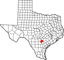 | |
| Town | ||
| Unincorporated communities | ||
| Ghost towns | ||
| Footnotes | ‡This populated place also has portions in an adjacent county or counties | |
