La Richardais
| La Richardais Kerricharzh-an-Arvor | ||
|---|---|---|
|
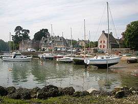
Harbour | ||
| ||
 La Richardais | ||
|
Location within Brittany region  La Richardais | ||
| Coordinates: 48°36′26″N 2°02′02″W / 48.6072°N 2.0339°WCoordinates: 48°36′26″N 2°02′02″W / 48.6072°N 2.0339°W | ||
| Country | France | |
| Region | Brittany | |
| Department | Ille-et-Vilaine | |
| Arrondissement | Saint-Malo | |
| Canton | Dinard | |
| Intercommunality | Côte d'Emeraude | |
| Government | ||
| • Mayor (2014–2020) | Pierre Contin | |
| Area1 | 3.14 km2 (1.21 sq mi) | |
| Population (2009)2 | 2,367 | |
| • Density | 750/km2 (2,000/sq mi) | |
| Time zone | CET (UTC+1) | |
| • Summer (DST) | CEST (UTC+2) | |
| INSEE/Postal code | 35241 / 35780 | |
| Elevation | 0–55 m (0–180 ft) | |
|
1 French Land Register data, which excludes lakes, ponds, glaciers > 1 km² (0.386 sq mi or 247 acres) and river estuaries. 2 Population without double counting: residents of multiple communes (e.g., students and military personnel) only counted once. | ||
.svg.png)
La Richardais (Breton: Kerricharzh-an-Arvor) is a commune in the Ille-et-Vilaine department of Brittany in northwestern France.
Population
Inhabitants of La Richardais are called richardaisiens in French.
| Historical population | ||
|---|---|---|
| Year | Pop. | ±% |
| 1881 | 946 | — |
| 1911 | 882 | −6.8% |
| 1936 | 829 | −6.0% |
| 1962 | 950 | +14.6% |
| 1968 | 972 | +2.3% |
| 1975 | 1,222 | +25.7% |
| 1982 | 1,381 | +13.0% |
| 1990 | 1,801 | +30.4% |
| 1999 | 2,120 | +17.7% |
| 2009 | 2,367 | +11.7% |
See also
References
External links
| Wikimedia Commons has media related to La Richardais. |
- Official website (French)
- French Ministry of Culture list for La Richardais (French)
This article is issued from Wikipedia - version of the 11/12/2014. The text is available under the Creative Commons Attribution/Share Alike but additional terms may apply for the media files.