La Chapelle-d'Armentières
| La Chapelle-d’Armentières | ||
|---|---|---|
 | ||
| ||
 La Chapelle-d’Armentières | ||
|
Location within Hauts-de-France region  La Chapelle-d’Armentières | ||
| Coordinates: 50°40′25″N 2°53′46″E / 50.6736°N 2.8961°ECoordinates: 50°40′25″N 2°53′46″E / 50.6736°N 2.8961°E | ||
| Country | France | |
| Region | Hauts-de-France | |
| Department | Nord | |
| Arrondissement | Lille | |
| Canton | Armentières | |
| Intercommunality | Lille Métropole | |
| Government | ||
| • Mayor (2008–2014) | Bernard Coisne | |
| Area1 | 10.33 km2 (3.99 sq mi) | |
| Population (1999)2 | 7,903 | |
| • Density | 770/km2 (2,000/sq mi) | |
| Time zone | CET (UTC+1) | |
| • Summer (DST) | CEST (UTC+2) | |
| INSEE/Postal code | 59143 / 59930 | |
| Elevation |
15–20 m (49–66 ft) (avg. 18 m or 59 ft) | |
|
1 French Land Register data, which excludes lakes, ponds, glaciers > 1 km² (0.386 sq mi or 247 acres) and river estuaries. 2 Population without double counting: residents of multiple communes (e.g., students and military personnel) only counted once. | ||
La Chapelle-d'Armentières is a commune of the Nord department in northern France.
It is part of the Urban Community of Lille Métropole.
Heraldry
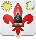 |
The arms of La Chapelle-d'Armentières are blazoned : Argent, a fleurs de lys gules, between in chief a sun and a crescent bendwise sinister Or, in center point overall, a church portal sable. |
See also
References
| Wikimedia Commons has media related to La Chapelle-d'Armentières. |
.svg.png)
This article is issued from Wikipedia - version of the 11/13/2016. The text is available under the Creative Commons Attribution/Share Alike but additional terms may apply for the media files.