LaGrange, Georgia
| LaGrange, Georgia | |
|---|---|
| City | |
|
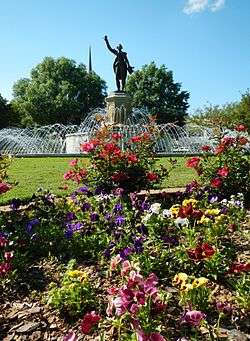
A statue of the Marquis de LaFayette stands atop a fountain in LaGrange's LaFayette Square. | |
 Location in Troup County and the state of Georgia | |
| Coordinates: 33°2′12″N 85°01′55″W / 33.03667°N 85.03194°WCoordinates: 33°2′12″N 85°01′55″W / 33.03667°N 85.03194°W | |
| Country | United States |
| State | Georgia |
| County | Troup |
| Government | |
| • Mayor | Jim Thornton[1] |
| Area | |
| • Total | 29.5 sq mi (76.5 km2) |
| • Land | 29.0 sq mi (75.0 km2) |
| • Water | 0.6 sq mi (1.5 km2) |
| Elevation | 781 ft (238 m) |
| Population (2012) | |
| • Total | 30,478[2] |
| • Density | 1,033/sq mi (398/km2) |
| Time zone | EST (UTC-5) |
| • Summer (DST) | EDT (UTC-4) |
| ZIP codes | 30240, 30241, 30261 |
| Area code(s) | 706 |
| FIPS code | 13-44340[3] |
| GNIS feature ID | 0316522[4] |
| Website |
LaGrange-GA |
LaGrange is a city and the county seat of Troup County, Georgia, United States. The population of the city was estimated to be 30,452 in 2013 by the U.S. Census Bureau.[5] It is the principal city of the LaGrange, Georgia Micropolitan Statistical Area, which is included in the Atlanta-Sandy Springs-Gainesville, Georgia-Alabama (part) Combined Statistical Area.
LaGrange is home to LaGrange College, the oldest private college in the state. Its proximity to West Point Lake, a few miles to the west, makes it a tourist destination for bass fishermen and water sports enthusiasts.[6]
History
LaGrange is named after the country estate near Paris of the wife of the Marquis de La Fayette, who visited Georgia in 1825 and remarked on the similar topography of that regio of Georgia and his estate.[7]
The settlement of LaGrange began in the early 19th century, soon after the territory was ceded by the Creek Indians and the subsequent establishment of Troup County. The city was incorporated in December 1828. During the American Civil War, LaGrange was defended by a volunteer women's auxiliary group known as the Nancy Harts or Nancy Hart Rifles, after Nancy Hart. After the Confederate defeat in nearby West Point, Georgia, the Union troops, led by Colonel Oscar La Grange, marched north to LaGrange, with Confederate prisoners near the front of the column. The Nancy Harts assembled and negotiated a surrender.
Although local assets were burned and looted by Union troops, Colonel La Grange spared the private homes of LaGrange, including Bellevue, the home of Senator Benjamin Harvey Hill. This may have been a returned favor. Col. La Grange had previously been under Confederate medical care for wounds received and had been attended by the niece of Senator Hill. Afterward, La Grange was exchanged for a Confederate prisoner and returned to battle duty. This was an opportunity to return the kindness he was given.
To show their gratitude for sparing their homes, one of the Nancy Harts hosted a dinner for Col. La Grange, and he paroled some local prisoners so they could attend. Many women of the town cooked all night to provide the meal. The next morning the Federal troops marched out, taking various men of the town as prisoners of war. They were soon released, though, when it was learned that General Lee had surrendered.
LaGrange developed as a railroad center and as an industrial center for the textile industry which was established and grew from the late 19th century, peaking in the mid-20th century. The city was fortunate that as the textile industry declined, it was replaced with a diverse mixture of new industry, which provided steady local employment for a number of years.
The city maintained its position as a transportation hub with the completion of Interstates 85 and 185, which pass through LaGrange. This location has benefited the city's development, by providing industrial and commercial access for businesses, such as a Wal-Mart Distribution Center.
Interface, the world's largest manufacturer of carpet tile, was founded in LaGrange in 1973 and continues to have its largest manufacturing presence there. LaGrange is also the North American headquarters for Caterpillar's forestry division. Just south of LaGrange in neighboring West Point, also in Troup County, KIA Motors has their only US assembly plant, and many of KIA's suppliers are located in LaGrange.
The City of LaGrange is a full-service utility provider for the region, including electricity, natural gas, water, sewer, refuse collection, and telecommunication. The city was named "Intelligent Community of the Year" by the Intelligent Community Forum in 2000, joining other cities such as New York, Singapore, Seoul, Glasgow, and Toronto in a very exclusive club.
Geography
LaGrange is located at 33.0367° N, 85.0319° W. The city is located in west central Georgia along Interstates 85 and 185, which run east of the city, with Interstate 85 leading northeast 68 mi (109 km) to Atlanta and southwest 96 mi (154 km) to Montgomery, Alabama. Interstate 85 gives direct access to the city from exits 13, 14, and 18. Interstate 185 runs south from the city 43 mi (69 km) to Columbus. U.S. Route 27, U.S. Route 29, Georgia State Route 219, and Georgia State Route 109 all meet in the interior of the city. According to the U.S. Census Bureau, the city has an area of 112.8 mi (181.5 km), in which 111.4 mi (179.3 km) is land and 1.4 mi (2.3 km) is water.
Government
LaGrange is governed by a mayor and city council. The mayor is elected city-wide and the six council members are elected by district. Jim Thornton is the current mayor and chief executive officer of the city. The daily operations of the city are administered by a full-time City Manager. The mayor and all council members are elected for four-year terms on a nonpartisan basis.
Demographics
| Historical population | |||
|---|---|---|---|
| Census | Pop. | %± | |
| 1850 | 1,523 | — | |
| 1870 | 2,053 | — | |
| 1880 | 2,295 | 11.8% | |
| 1890 | 3,090 | 34.6% | |
| 1900 | 4,274 | 38.3% | |
| 1910 | 5,587 | 30.7% | |
| 1920 | 17,038 | 205.0% | |
| 1930 | 20,131 | 18.2% | |
| 1940 | 21,983 | 9.2% | |
| 1950 | 25,025 | 13.8% | |
| 1960 | 23,632 | −5.6% | |
| 1970 | 23,301 | −1.4% | |
| 1980 | 24,204 | 3.9% | |
| 1990 | 25,597 | 5.8% | |
| 2000 | 25,998 | 1.6% | |
| 2010 | 29,588 | 13.8% | |
| Est. 2015 | 30,695 | [8] | 3.7% |
As of the 2013 U.S. Census estimate,[5] there were 30,452 people in 11,233 households residing in the city. The population density was 1033 per square mile. The racial makeup of the city was 48.0% Black Only, 44.5% White Only, 4.7% Hispanic/Latino, 2.5% Asian Only, 1.8% mixed race, and 0.3% other. The median household income was $30,653.
Education
Troup County School District
The Troup County School System holds pre-school to grade twelve, and consists of fifteen elementary schools, three middle schools (Callaway Middle School, Gardner Newman Middle School, and Long Cane Middle School) and three high schools (Callaway High School, LaGrange High School,and Troup County Comprehensive High School. The county is divided into three school zones. The Troup County School System serves Hogansville, LaGrange, and West Point. It is home to over twenty new and recently renovated schools.
Private education
- LaGrange Academy
- Dawson Street Academy
- Lafayette Christian
- Sound Doctrine Christian Academy
- Oak Grove Christian Academy
- Hillside Montessori
Higher education
Transportation
The LaGrange-Callaway Airport is located southwest of the city.
Sister cities
LaGrange has three sister cities, as designated by Sister Cities International, Inc. (SCI):[10]
 Craigavon, Northern Ireland, United Kingdom
 Poti, Samegrelo-Zemo Svaneti, Georgia
 Aso, Kumamoto, Japan
The city is in the process of developing a sister city relationship in South Korea.
Notable people
- Hammett L. Bowen, Jr. - recipient of the Medal of Honor
- Fuller Earle Callaway - textile magnate[11]
- Mike Cameron - Major League Baseball player
- Wallace H. Clark, Jr. - pathologist and cancer researcher; born (c.1924) and raised in LaGrange
- Joyce Grable - former professional wrestler; born (c. 1952) and raised in LaGrange.
- Jimmy Haynes Major League Baseball Player
- Tom Jarriel - ABC news correspondent; born in LaGrange in 1934
- John Johnson - NFL player
- Elijah Kelley - actor
- Wynona Lipman (1923–1999), first African-American woman elected to the New Jersey Senate.
- Andy "Bubba Sparxxx" Mathis - rapper
- Lincoln Wayne "Chips" Moman - record producer and songwriter
- Fred Newman - actor
- James M. Sprayberry - recipient of the Medal of Honor
- Horace Ward - first African American federal judge in Georgia; also the first person to attempt to integrate the University of Georgia's law school
- Wesley Woodyard - NFL player
- Louis Tompkins Wright - physician, graduate of Harvard Medical School, first African-American physician to be appointed to the staff of a New York City municipal hospital; notable for many scientific breakthroughs, including the introduction of intradermal smallpox vaccination
- Mike Lazzo - network executive for Adult Swim
Gallery
-
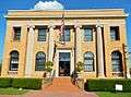
LaGrange City Hall
-
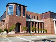
Troup County Government Center in LaGrange
-
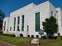
Built in 1939, the old Troup County Courthouse is still in use today as the Juvenile Courthouse. The jail behind it was torn down in 2001 when the Troup County Government Center was built. It was added to the National Register of Historic Places on June 8, 1995.
-
.JPG)
Senator Benjamin Harvey Hill's LaGrange home, Bellevue, was built in 1854-55 in the Greek Revival plantation style. The home was acquired by the Fuller E. Callaway Foundation and donated to the LaGrange Woman's Club in the 1950s. It was added to the National Register of Historic Places on November 7, 1972 and designated as a National Historic Landmark on November 7, 1973.
-
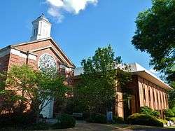
LaGrange College is the oldest private college in Georgia. Affiliated with the United Methodist Church, it has an enrollment of about 1,000 students.

See also
References
- ↑ "Official Website of the City of LaGrange, GA". lagrange-ga.org.
- ↑ "LaGrange (city) QuickFacts from the US Census Bureau". census.gov.
- ↑ "American FactFinder". United States Census Bureau. Retrieved 2008-01-31.
- ↑ "US Board on Geographic Names". United States Geological Survey. 2007-10-25. Retrieved 2008-01-31.
- 1 2 "Quickfacts US Census estimate".
- ↑ "West Point Lake, GA". www.recreation.gov. Retrieved 18 July 2015.
- ↑ Johnson, Forrest Clark. "La Grange". New Georgia Encyclopedia. Georgia Humanities Council and University of Georgia Press. Retrieved 6 July 2016.
- ↑ "Annual Estimates of the Resident Population for Incorporated Places: April 1, 2010 to July 1, 2015". Retrieved July 2, 2016.
- ↑ "Census of Population and Housing". Census.gov. Retrieved June 4, 2015.
- ↑ LaGrange's Sister City Program, Retrieved June 26, 2010.
- ↑ Gary N. Mock, "Fuller E. Callaway, LaGrange, GA," textilehistory.org/, 2009.
External links
- Official website
- LaGrange - Troup County Chamber of Commerce
- Nancy Harts at Battle of West Point website
- "Legacy: The Secret History of Proto-Fascism in America's Greatest Little City"
Municipalities and communities of Troup County, Georgia, United States | ||
|---|---|---|
| Cities | 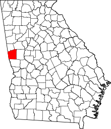 | |
| Footnotes | ‡This populated place also has portions in an adjacent county or counties | |