Lý Sơn District
| Lý Sơn District Huyện Lý Sơn | |
|---|---|
| District | |
 | |
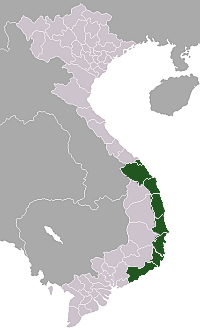
 Lý Sơn District Location of Lý Sơn District in Vietnam | |
| Coordinates: 15°22′51″N 109°07′03″E / 15.38083°N 109.11750°ECoordinates: 15°22′51″N 109°07′03″E / 15.38083°N 109.11750°E | |
| Country |
|
| Region | South Central Coast |
| Province | Quảng Ngãi |
| Capital | Ly Vinh[1] |
| Area | |
| • Total | 10 km2 (4 sq mi) |
| Population (2003)[1] | |
| • Total | 19,695 |
| Time zone | UTC + 7 (UTC+7) |
Lý Sơn (![]() listen), previously known as Cù Lao Ré,[2] is a district in Quảng Ngãi Province, off the South Central Coast of Vietnam.
listen), previously known as Cù Lao Ré,[2] is a district in Quảng Ngãi Province, off the South Central Coast of Vietnam.
Geography and geology
The district covers approximately 9.97 km² of land, on two off-shore volcanic islands in the East Sea, and a few islets. The main island, Lý Sơn (Cù Lao Ré) has three prominent craters, the largest of which is Mount Thoi Loi (Thới Lới). Hydrothermal waters on Lý Sơn provide heat for the local power plant. The secondary island is known as Little Island (Cù Lao Bờ Bãi) and is also well populated.
History
Remains of the pre-200 C.E. Sa Huỳnh culture have been found on the islands. The Cham used Ly Son as a transhipment base. Xó La well, one of the wells used to provide fresh water for ships, still remains right on the shore of the main island and is still in use.[3] In the 17th century the Nguyễn lords started a colony on the islands from An Vĩnh, Bình Sơn District, in Quảng Ngãi, as part of the activities of the Hoàng Sa Company's development of the Paracel Islands.[4] During the United States involvement in Vietnam, Lý Sơn was the site of a U.S. Navy radar installation. The radar site was used to track shipping along the Vietnamese coast.
Economy
The economy was founded on,[4] and remains, primarily based on seafood extraction. Ly Son is a major offshore fishing center with an output of 29,000 tonnes worth VND241.2 billion ($11.4 million) in 2012, accounting for almost one fourth of Quảng Ngãi's total.[5]
Lý Sơn is also known throughout Vietnam for its production of a special variety of garlic,[6] although coastal sand mining to support its extensive cultivation has led to significant erosion. In the 21st century Lý Sơn began to develop its tourist industry.
Culture
As in other parts of coastal Vietnam[7] whales are important in local mythology and religion. Around one hundred whale skeletons are kept in temples, the largest and most important of which is in Tan Temple in An Hai Commune.[8] According to a local legend, the 200-year-old skeleton are the remains of Nam Hai Dong Dinh Dai Vuong (the king of whales), the most powerful whale in the East Sea.[8] Whale skeletons are worshiped and huge funerals are held when a stranded whale is found because they are believed to protect fishers while they are at sea.[8]
Administrative divisions
There are three communes in Lý Sơn District:
- An Vĩnh and An Hải on the main island
- An Bình on Bờ Bãi Island in the north[9]
The district government is located in An Vĩnh.[9]
Gallery
-
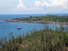
Lý Sơn Island in the background, seen from Sơn Thủy area.
Notes
- 1 2 "Districts of Vietnam". Statoids. Retrieved March 20, 2009.
- ↑ Ré, Cù Lao at GEOnet Names Server
- ↑ Hardy 2009, 111
- 1 2 Monique Chemillier-Gendreau, Sovereignty Over the Paracel and Spratly Islands Kluwer Law International, page 72, ISBN 90-411-1381-9. retrieved on 28 April 2010
- ↑ "Fine weather brings bumper fishing haul". Viet Nam News. 3 January 2013. Retrieved 5 January 2013.
- ↑ "Garlic smells sweet to one island" Vietnam Development Gateway, 26 June 2007, accessed 28 April 2010
- ↑ Why Vietnamese villagers are dragging dead whales inland Adam Bray, CNN (25 February 2010):
- 1 2 3 The fishermen’s protector on Ly Son Island Saigon Times (6 August 2010):
- 1 2 Viet Nam Administrative Atlas. Cartographic Publishing House, Hanoi 2010
- References
- Hardy, Andrew (2009): "Eaglewood and the Economic History of Champa and Central Vietnam" in Hardy, Andrew et al.: Champa and the Archeology of My Son (Vietnam). NUS Press, Singapore
External links
- "Ly Son District Portal" with articles, images, video, news,... to introduction about Ly Son District (Island - Cu Lao Re)
- "Ly Son People Portal" with articles, images, video, news,... to introduction, connection, trading promotion, tourism, ly son garlic.
- "Ly Son garlic Portal" introduction, trading promotion ly son garlic.
- "Ly Son people blog" introduction, news, gallery, video about Ly Son.