Løten
| Løten kommune | |||
|---|---|---|---|
| Municipality | |||
 | |||
| |||
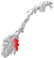
 Løten within Hedmark | |||
| Coordinates: 60°49′31″N 11°23′27″E / 60.82528°N 11.39083°ECoordinates: 60°49′31″N 11°23′27″E / 60.82528°N 11.39083°E | |||
| Country | Norway | ||
| County | Hedmark | ||
| District | Hedmarken | ||
| Administrative centre | Løten | ||
| Government | |||
| • Mayor (2007) | Bente Elin Lilleøkseth (Ap) | ||
| Area | |||
| • Total | 369 km2 (142 sq mi) | ||
| • Land | 362 km2 (140 sq mi) | ||
| Area rank | 252 in Norway | ||
| Population (2004) | |||
| • Total | 7,282 | ||
| • Rank | 137 in Norway | ||
| • Density | 20/km2 (50/sq mi) | ||
| • Change (10 years) | 3.4 % | ||
| Demonym(s) | Løtensokning[1] | ||
| Time zone | CET (UTC+1) | ||
| • Summer (DST) | CEST (UTC+2) | ||
| ISO 3166 code | NO-0415 | ||
| Official language form | Bokmål | ||
| Website |
www | ||
|
| |||

Løten is a municipality in Hedmark county, Norway. It is part of the traditional region of Hedmarken. The administrative centre of the municipality is the village of Løten. The parish of Løiten was established as a municipality on 1 January 1838 (see formannskapsdistrikt).
General information
Name
The municipality (originally the parish) is named after an old farm (Old Norse Lautvin). The actual farm is probably the one which is now called Prestgarden (meaning "the vicarage"), where the first church was built. The first element is laut which means "hollow depression". (There is a long depression between the Prestgarden and the old church.) The last element is vin which means "meadow" or "pasture".
From about 1500 until 1838 the name was written "Leuten" or "Leuthen". From 1838 until 1918 the name was written "Løiten". It has been spelled Løten since 1918.
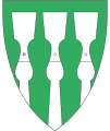
Coat-of-arms
The coat-of-arms is from modern times. They were granted on 7 September 1984. The arms show a gold-colored drinking horn from the Middle Ages on a red background. It represents the historical importance of growing wheat and also the products of the modern Løiten Brænderi (Løten brewery).[2]
History
There has been traffic from east to west through Løten, throughout all recorded periods of history and archeological evidence supports earlier trade along this route. The old town center was formed around the Løten Church, which is from the 13th century.
When King Christian IV of Denmark prohibited the importation of German beer in the early 17th Century, distillation began in Norway. In 1624, distilled alcohol was prohibited at weddings, and by 1638 King Christian forbade the clergy the right to distill in their own homes. The corn-growing districts of Løten, Vang (the former municipality in Hedmark), and Romedal all became famous for their distilleries. "Gamle Løiten" from Løiten Brænderi, which was established in 1855, was a highly prized ‘akvavit’ produced in Løten.[3]
When the railway was opened in 1862, Løten Station became the new centre of trade and management.
Geography
Løten is the most eastern of the original villages in Hedmark where it is lies between Hamar municipality to the west northwest, Stange municipality to the west southwest, and Elverum municipality to the east. Small portions of the municipality border on Åmot in the far north and Våler in the south. The moorland Hedmarksvidda lies in the north.
The largest townships in Løten is Ådalsbruk, with an industrial history.
Within Løten lies the "border" between the wheat fields of the lower eastern Norway, around and south of lake Mjøsa, and the taiga, the boreal coniferous forests that stretches from eastern Norway until Siberia. This border situation between the cultivated farm land and the wilderness were made clear by the poet Rolf Jacobsen, citizen of the neighbouring city Hamar, in his classic poem "Tanker ved Ånestadkrysset" (Thoughts at the Ånestad crossroad).
Notable residents
- Artist, Edvard Munch was born in Løten on 12 December 1863.
- Kristoffer Nilsen Svartbækken Grindalen (1804–1876) was the last person in Norway to be sentenced to death for murder. He was from Elverum, but committed murder in Løten, and was also executed there.
References
- ↑ "Navn på steder og personer: Innbyggjarnamn" (in Norwegian). Språkrådet. Retrieved 2015-12-01.
- ↑ Norske Kommunevåpen (1990). "Nye kommunevåbener i Norden". Retrieved 2008-12-22.
- ↑ Stagg, Frank Noel (1956). East Norway and its Frontier. George Allen & Unwin, Ltd.
External links
 Media related to Løten at Wikimedia Commons
 The dictionary definition of Løten at Wiktionary
- Municipal fact sheet from Statistics Norway