Kyriaki
This article is about a modern village in Greece. For the saint, see Saint Kyriaki. For other uses, see Agia Kyriaki (disambiguation).
| Kyriaki Κυριάκι | |
|---|---|
|
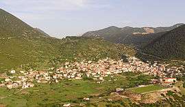
A view of Kyriaki. | |
 Kyriaki | |
|
Location within the regional unit  | |
| Coordinates: 38°21′N 22°47′E / 38.350°N 22.783°ECoordinates: 38°21′N 22°47′E / 38.350°N 22.783°E | |
| Country | Greece |
| Administrative region | Central Greece |
| Regional unit | Boeotia |
| Municipality | Livadeia |
| • Municipal unit | 130.36 km2 (50.33 sq mi) |
| Highest elevation | 800 m (2,600 ft) |
| Lowest elevation | 745 m (2,444 ft) |
| Population (2011)[1] | |
| • Municipal unit | 2,298 |
| • Municipal unit density | 18/km2 (46/sq mi) |
| Time zone | EET (UTC+2) |
| • Summer (DST) | EEST (UTC+3) |
| Postal code | 320 06 |
| Area code(s) | +30-2267-xxx-xxx |
| Vehicle registration | ΒΙ |
Kyriaki (Greek: Κυριάκι) is a village and a community of the Livadeia municipality, Greece. Before the 2011 local government reform Kyriaki was an independent community.[2] The 2011 census recorded 2,298 in the community of Kyriaki and 2,185 in the village proper.[1] The community of Kyriaki covers an area of 130.36 km2.[3]
Settlements
- Kyriaki
- Agios Athanasios
- Karyoti
- Tarsos
- Panagia Kalamiotissa
Population
| Year | Village population | Community population |
|---|---|---|
| 1981 | 2,320 | - |
| 1991 | 2,148 | - |
| 2001 | 2,194 | 2,420 |
| 2011[1] | 2,185 | 2,298 |
Geography
A few farmlands are around the area. The mountains that are mainly filled with grasslands and rocks covers around the area, forests are found mainly in low-lying areas. The Gulf of Corinth is approximately 5 to 6 km southwest.
See also
External links
References
| Wikimedia Commons has media related to Kyriaki. |
- 1 2 3 "Απογραφή Πληθυσμού - Κατοικιών 2011. ΜΟΝΙΜΟΣ Πληθυσμός" (in Greek). Hellenic Statistical Authority.
- ↑ Kallikratis law Greece Ministry of Interior (Greek)
- ↑ "Population & housing census 2001 (incl. area and average elevation)" (PDF) (in Greek). National Statistical Service of Greece.
This article is issued from Wikipedia - version of the 11/28/2016. The text is available under the Creative Commons Attribution/Share Alike but additional terms may apply for the media files.