Kyparissia
| Kyparissia Κυπαρισσία | |
|---|---|
 | |
 Kyparissia | |
|
Location within the regional unit 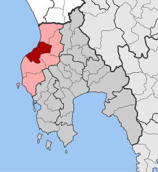 | |
| Coordinates: 37°15′N 21°40′E / 37.250°N 21.667°ECoordinates: 37°15′N 21°40′E / 37.250°N 21.667°E | |
| Country | Greece |
| Administrative region | Peloponnese |
| Regional unit | Messenia |
| Municipality | Trifylia |
| • Municipal unit | 101.0 km2 (39.0 sq mi) |
| Elevation | 52 m (171 ft) |
| Population (2011)[1] | |
| • Municipal unit | 7,728 |
| • Municipal unit density | 77/km2 (200/sq mi) |
| Community[1] | |
| • Population | 5,784 (2011) |
| Time zone | EET (UTC+2) |
| • Summer (DST) | EEST (UTC+3) |
| Postal code | 245 00 |
| Area code(s) | 27610 |
| Vehicle registration | ΚΜ |
| Website | www.dimostrifylias.gr |
Kyparissia (Greek: Κυπαρισσία) is a town and a former municipality in northwestern Messenia, Peloponnese, Greece. Since the 2011 local government reform it is part of the municipality Trifylia, of which it is the seat and a municipal unit.[2] The municipal unit has an area of 101.018 km2.[3] The town proper has around 5,100 inhabitants.
Geography
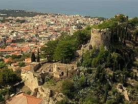
The town is situated on the Gulf of Kyparissia, a bay of the Ionian Sea. It is 38 km north of Pylos, 46 km northwest of Kalamata and 51 km southeast of Pyrgos. The Greek National Road 9 (Pyrgos - Methoni) passes through the town. Kyparissia is the terminus of a now disused railway line from Kalo Nero, on the line from Pyrgos to Kalamata. The town has a port, which is mainly used for cargo purposes. On a hill east of the town centre lies a fortress built during the Frankish period.
Subdivisions
The municipal unit Kyparissia is subdivided into the following communities (constituent villages and 2011 population in brackets):
- Armenioi (pop: 314)
- Faraklada (pop: 334)
- Kyparissia (Kyparissia, Memi, Blemenianoi, Myloi, Rouzaki, Terpsithea, total pop: 5,784)
- Mouriatada (Mouriatada, Karvouni, total pop: 54)
- Myro (Myro, Alimaki, total pop: 9)
- Perdikoneri (pop: 212)
- Raches (pop: 182)
- Spilia (pop: 511)
- Stasio (pop: 160)
- Vryses (pop: 115)
- Xirokampos (pop: 53)
History
The ancient Greek town Cyparissia (Ancient Greek: Κυπαρισσία)[4] was already mentioned by Homer in his Iliad.
Ancient writers took note of Cyparissia's beautiful situation upon the sides of one of the offshoots of the range of mountains, which run along this part of the Messenian coast. Upon the narrow summit of the rocks later occupied by a castle built in the Middle Ages, stood the ancient acropolis. There is no harbour upon the Messenian coast north of Pylos; but Leake remarks that the roadstead at Cyparissia seems to be the best on this part of the coast; and in ancient times the town probably possessed an artificial harbour, since traces of a mole may still be seen upon the sea-shore. This was probably constructed on the restoration of Messene by Epaminondas; for it was necessary to provide the capital of the new state with a port, and no spot was so suitable for this object as Cyparissia. Hence we find Messene and the harbour Cyparissia mentioned together by Scylax[5] Pausanias found in the town a temple of Apollo, and one of Athena Cyparissia. The town continued to coin money down to the time of Severus.
Stephanus calls Cyparissia a city of Triphylia, and Strabo[6] also distinguishes between the Triphylian and Messenian Cyparissia, but on what authority we do not know.[7][8]
At a relatively late stage Cyparissia was a bishopric[9] that today, no longer being residential, is listed by the Catholic Church as a titular see.[10]
In the Middle Ages it was called Arkadía, a name which was transferred from the interior of the peninsula to this place upon the coast. Under the Principality of Achaea, Kyparissia/Arkadia was the seat of the Barony of Arcadia, which was the last Frankish territory (except for the Venetian possessions) to fall to the Despotate of the Morea, in 1432.[11]
In 1460 Kyparissia came under Ottoman control, and remained so, with the exception of thirty years of Venetian rule, until the Greek War of Independence which began in 1821.
Kyparissia continued to bear the name Arkadia till its destruction by Ibrahim Pasha in 1825, during the Greek War of Independence and when rebuilt it resumed its ancient name Cyparissia, by which it is now called. Some remains of ancient walls may be traced around the modern castle; and below the castle on the slope of the hill, near the church of Saint George, are some fragments of columns. On the south side of the town, close to the sea-shore, a fine stream rushes out of the rock and flows into the sea; and a little above is a basin with a spring of water, near which are some stones belonging to an ancient structure. This is the ancient fountain sacred to Dionysus, which Pausanias perceived near the entrance of the city, on the road from Pylus.
Historical population
| Year | Community | Municipal unit |
|---|---|---|
| 1981 | 4,636 | - |
| 1991 | 5,149 | - |
| 2001 | 5,708 | 8,648 |
| 2011 | 5,784 | 7,728 |
Famous residents
- Dimitrios Pitsinis (1925–2003), Doctor/General Surgeon
- Konstantinos Lamprinopoulos (1893-1965), politician, Mayor of Patras
- Theodoros Roussopoulos (1963-), journalist, politician
- Kostis Palamas (1859-1943), poet
See also
References
- 1 2 "Απογραφή Πληθυσμού - Κατοικιών 2011. ΜΟΝΙΜΟΣ Πληθυσμός" (in Greek). Hellenic Statistical Authority.
- ↑ Kallikratis law Greece Ministry of Interior (Greek)
- ↑ "Population & housing census 2001 (incl. area and average elevation)" (PDF) (in Greek). National Statistical Service of Greece.
- ↑ Such form is found in Strabo viii. pp. 349, 359; Steph. B. s. v.; Liv. xxxii. 21; and Plin. iv. 5. s. 7. Homer has Κυπαρισσήεις, Il. ii. 593; Pausanias has Κυπαρισσιαί, Paus. iv. 36. § 7; Ptolemy has Κυπάρισσαι, Ptol. iii. 16. § 7; the form Κυπάρισσος is in Scylax, p. 16 and Pomponius Mela, ii. 3.
- ↑ p. 16.
- ↑ viii. p. 349
- ↑ Leake, Morea, vol. i. p. 68 et seq.; Boblaye, Recherches, p. 115; Curtius, Peloponnesos, vol. ii. p. 184, et seq.
- ↑
 Smith, William, ed. (1854–1857). "Cyparissia". Dictionary of Greek and Roman Geography. London: John Murray.
 - ↑ Raymond Janin, v. Cyparissia, in Dictionnaire d'Histoire et de Géographie ecclésiastiques, vol. XIII, Paris 1956, coll. 1147-1148
- ↑ Annuario Pontificio 2013 (Libreria Editrice Vaticana 2013 ISBN 978-88-209-9070-1), p. 870
- ↑ Bon, Antoine (1969). La Morée franque. Recherches historiques, topographiques et archéologiques sur la principauté d’Achaïe (in French). Paris: De Boccard. pp. 412–414.
 This article incorporates text from a publication now in the public domain: Smith, William, ed. (1854–1857). "Cyparissia". Dictionary of Greek and Roman Geography. London: John Murray.
External links
| Wikivoyage has a travel guide for Kyparissi. |
 |
Ionian Sea | Avlonas | | |
| |
Aetos | |||
| ||||
| | ||||
| Filiatra | Filiatra | Tripyla |