Kusapin
| Kusapin | |
|---|---|
 Kusapin | |
| Coordinates: 9°10′48″N 81°53′24″W / 9.18000°N 81.89000°WCoordinates: 9°10′48″N 81°53′24″W / 9.18000°N 81.89000°W | |
| Country | Panama |
| Province | Ngöbe Buglé |
| Population (2010) | |
| • Total | 33.121 hab. |
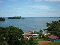
Kusapín (Sabricotte) is a district of the county Panamanian indigenous Ngobe Bugle. Its capital is the town of Kusapín.[1] It has an area of 1,693.2 km2 and a population of 33.121 inhabitants according to 2010 census data.[2] The district's population is predominantly ethnic Ngobe Bugle.
Political division
The district includes the communities of Kusapín, Blue Bay, Santa Catalina, Yucca Loma, Rio Chiriqui Tobobe and Llano Bonito.
History
The district is created Kusapín from Law 10 of March 1997. Next to the district Kankintú, is part of the region in Ñokribu Ngobe Bugle.
Getting there?
Being located in the coastal regions of the province of Bocas del Toro, is necessary to travel by boat. These depart daily at 6:00 am and arrive at the port of Chiriqui Grande from 8 to 9 am, depending on weather conditions. Leaving the port to Kusapín at 11:00 am, drivers reliable as Rutilio Mr. Trotman, Roger Hooker, Chalito, Yimmi.
References
- ↑ Panama. Dirección de Estadística y Censo (2003). Panamá en cifras. La Dirección. ISSN 0078-8996. Retrieved 2014-12-06.
- ↑ http://www.censos2010.gob.pa/Resultados/cuadros.aspx
Sources
- World Gazeteer: Panama – World-Gazetteer.com