Kurnool
| Kurnool కర్నూలు کرنول | |
|---|---|
| City | |
|
View of Rajvihar Center, one of the busiest centres in Kurnool City | |
| Nickname(s): The Gateway of Rayalaseema | |
 Kurnool Location in Andhra Pradesh | |
| Coordinates: 15°50′N 78°03′E / 15.83°N 78.05°ECoordinates: 15°50′N 78°03′E / 15.83°N 78.05°E | |
| Country | India |
| State | Andhra Pradesh |
| District | Kurnool |
| Government | |
| • Type | Municipal corporation |
| • Body | Kurnool Municipal corporation |
| Area[1][2] | |
| • City | 65.91 km2 (25.45 sq mi) |
| Area rank | 105 |
| Elevation | 274 m (899 ft) |
| Population (2011)[3]// | |
| • City | 430,214 |
| • Rank |
106th (India) 5th (Andhra Pradesh) |
| • Density | 6,500/km2 (17,000/sq mi) |
| • Metro[4] | 484,327 |
| Languages | |
| • Official | Telugu |
| Time zone | IST (UTC+5:30) |
| PIN | 518001,518002,518003,518004 |
| Vehicle registration | AP 21 |
| Website | Kurnool Municipal Corporation |

Kurnool is a city, former princely state and the headquarters of Kurnool district in the Indian state of Andhra Pradesh.[5] The city is often referred as The Gateway of Rayalaseema.[6] It was the capital of Andhra State from 1 October 1953 to 31 October 1956. As of 2011 census, it is the fifth most populous city in the state with a population of 460,184.[1][2]
Etymology
The name Kurnool is derived from Kandanavolu.[7]
History
Palaeolithic era
The Ketavaram [8] rock paintings from the Paleolithic era and are (18 kilometres from Kurnool). Also the Jurreru Valley, Katavani Kunta[9] and Yaganti in Kurnool District have some important rock art's and painting's in the vicinity, may be dated from 35,000 to 40,000 years ago.
Early Feudal Era
Little was known about Kurnool town before the 11th century. The earliest knowledge of this settlement dates from the 11th century. It has developed as transit place on the southern banks of the river Tungabhadra. It was ruled by Cholas and later by Kakatiya kings in the 12th and 13th centuries.
Later on it became a jagir (autonomous feudal estate of the country under Jagirdars). Late it came under the influence of Vijayanagar kings and it was during the 16th century that Achyuta Raya built the Kurnool Fort.
During the 17th century it was ruled by Gopal Raja. The Pathan general Abdul Wahab conquered king Gopal Raja and ruled over the country for 16 years.
Mughal princely state
The town became a vassal princely state of the Mughal empire under Aurangazeb, who took control in 1686. The town was the capital and seat of ruling Muslim princes, styled Nawabs: [10]
- 1690 - .... Daud Khan (Dawood Khan)
- .... - 1724 Ibrahim Khan
- 1724 - 1733 Alif Khan
- 1733 - 1751 Himayat Bahadur Khan
- 1751 - 1792 Munawwar Khan
- 1792 - 181 Aluf Khan
- 1815 Muzaffar Khan
- 1815 - 1823 Munawwar Khan
- 1823 - 1839 Ghulam Rasul Khan (Gulam Rasool Khan)
British raj
In 1839 the British Government took over direct colonial control, deposing the unruly princely family, which remains prominent in India and made a new fortune in the UAE.
In 1858 it was made over to a Collector under the General regulations.
Post independence
The city served as the capital of Andhra State from 1953–1956, until in 1956, the Telangana region was merged with Andhra State to form Andhra Pradesh state, and its capital was shifted from Kurnool to Hyderabad.[11][12]
Geography and climate
Location
Kurnool is located at 15°50′00″N 78°03′00″E / 15.8333°N 78.05°E.[13] It has an average elevation of 273 metres (898 feet).
Kurnool lies on the banks of the Tungabhadra River. The Hundri and Neeva rivers also flow through the city. The K.C. Canal (Kurnool–Cuddapah) was built by the Dutch for transportation, but later used for irrigation.
Cityscape

Landmarks in and around the city include Konda Reddy Fort (or Kondareddy Burj) is the remnant of Kurnool fort on the north east part of the city.[14] Orvakal rock Garderns with a cave museum lies on the south east of the city.[15]
Climate
The climate is tropical with temperatures ranging from 26 °C (78.8 °F) to 46 °C (114.8 °F) in the summer and 12 °C (53.6 °F) to 31 °C (87.8 °F) in the winter. The average annual rainfall is about 705 millimetres (28 in).
| Climate data for Kurnool (1981–2010) | |||||||||||||
|---|---|---|---|---|---|---|---|---|---|---|---|---|---|
| Month | Jan | Feb | Mar | Apr | May | Jun | Jul | Aug | Sep | Oct | Nov | Dec | Year |
| Record high °C (°F) | 37.3 (99.1) |
39.9 (103.8) |
43.3 (109.9) |
44.8 (112.6) |
45.6 (114.1) |
45.6 (114.1) |
38.5 (101.3) |
37.8 (100) |
38.7 (101.7) |
38.4 (101.1) |
38.8 (101.8) |
34.4 (93.9) |
45.6 (114.1) |
| Average high °C (°F) | 31.7 (89.1) |
34.8 (94.6) |
38.2 (100.8) |
40.1 (104.2) |
40.5 (104.9) |
36.2 (97.2) |
33.6 (92.5) |
32.5 (90.5) |
32.9 (91.2) |
32.5 (90.5) |
31.2 (88.2) |
30.5 (86.9) |
34.6 (94.3) |
| Average low °C (°F) | 17.9 (64.2) |
20.3 (68.5) |
23.8 (74.8) |
26.7 (80.1) |
27.5 (81.5) |
25.5 (77.9) |
24.5 (76.1) |
23.9 (75) |
23.8 (74.8) |
22.8 (73) |
20.1 (68.2) |
17.8 (64) |
22.9 (73.2) |
| Record low °C (°F) | 8.3 (46.9) |
11.1 (52) |
12.8 (55) |
15.5 (59.9) |
19.4 (66.9) |
17.6 (63.7) |
19.2 (66.6) |
19.9 (67.8) |
17.0 (62.6) |
13.0 (55.4) |
9.3 (48.7) |
6.7 (44.1) |
6.7 (44.1) |
| Average precipitation mm (inches) | 4.0 (0.157) |
2.2 (0.087) |
9.8 (0.386) |
26.4 (1.039) |
50.4 (1.984) |
93.6 (3.685) |
121.4 (4.78) |
143.4 (5.646) |
145.0 (5.709) |
114.1 (4.492) |
23.0 (0.906) |
3.9 (0.154) |
737.2 (29.024) |
| Average precipitation days | 0.3 | 0.2 | 0.7 | 1.6 | 2.7 | 5.7 | 7.6 | 9.0 | 7.7 | 5.2 | 1.9 | 0.3 | 43.0 |
| Source: India Meteorological Department (record high and low up to 2010)[16][17] | |||||||||||||
Demographics
As per final data of 2011 census, Kurnool urban agglomeration had a population of 484,327. The literacy rate was 77.37 per cent.[19] note: The Office of Registrar General & Census Commissioner of India. note: UA = Urban Agglomeration.
Politics
It is the headquarters of the mandal, the revenue division and the district of the same name. From 1 October 1953 to 31 October 1956, Kurnool was also the state capital of Andhra State (not Andhra Pradesh), which was carved out of Madras State in 1953. Tanguturi Prakasam was the chief minister of Andhra State during this period. The present day District court buildings were used by the State Assembly. Now, Present MLA is S V Mohan Reddy.[20]
Education
The primary and secondary school education is imparted by government, aided and private schools of the School Education Department of the state.[21][22] The medium of instruction followed by different schools are English, Telugu.

There are good number of government and private educational institutions in the city. Some of the universities and colleges are
- Rayalaseema University
- Dr Abdul haq Urdu university kurnool,
- Kurnool Medical College
- G Pulla Reddy College of Engineering & Technology
- Indian institute of information technology design and manufacturing IIITDM Kurnool
- Osmania College, Kurnool
- Silver Jubilee Government Degree College
- Kurnool Medical College
Transport
Roads
Kurnool is well connected by road with State Capital Vijayawada. It is in halfway between [[Hyderabad and Bengaluru. National Highway 44 (India) connects Kurnool to Hyderabad. The State Highway 51 connects to Srisailam, Vinukonda, Guntur, Vijayawada. National_Highway_40_(India)_(new_numbering) runs from Kurnool to Chittoor are te major highways pasing through the city. The city has a total road length of 519.22 km[23] State owned bus transport system, APSRTC, operates buses from Kurnool bus station to other parts of the state.[24][25]]]
Railways
Kurnool railway station lies on the Hyderabad – Guntakal railway line. It is classified as an A–category station in the Hyderabad railway division of South Central Railway zone.
Economy
Kurnool is endowed with good mineral resources. The important minerals are Iron ore, Dolomite, lime stone, ochre, quartz stealite and silica.[26]
See also
References
- 1 2 http://ourkmc.com/Circulars/files/50__Binder1.pdf
- 1 2 "KURNOOL MUNICIPAL CORPORATION STATUS REPORT". Docslide.us.
- ↑ //"Andhra Pradesh (India): Districts, Cities, Towns and Outgrowth Wards – Population Statistics in Maps and Charts". citypopulation.de.
- ↑ "Andhra Pradesh (India): State, Major Agglomerations & Cities – Population Statistics in Maps and Charts". citypopulation.de.
- ↑ "District Census Handbook : Kurnool" (PDF). Census of India. p. 50. Retrieved 21 August 2015.
- ↑ Sarkar, Siddhartha (2011). International Journal of Economic and Political Integration: Vol.1, No.1. Universal-Publishers. p. 15. ISBN 978-1-61233-544-5. Retrieved 18 July 2015.
- ↑ "Heritage in Kurnool". AP Tourism Department. Retrieved 10 August 2014.
- ↑ http://www.aparchaeologymuseum.com/wp-content/uploads/2012/06/Kurnool.pdf
- ↑ Petraglia, Michael. "New rock art discoveries in the Kurnool District, Andhra Pradesh, India". academia.edu. Retrieved 28 May 2014.
- ↑ Cahoon, Ben. "Indian Princely States K-Z".
- ↑ "The Indian Express - Google News Archive Search". google.com.
- ↑ Somasekhar, Ch RS Sarma / M. "Capital loss: Madras, Kurnool, now Hyderabad". The Hindu Business Line. Retrieved 11 April 2016.
- ↑ "Maps, Weather, and Airports for Kurnool, India". fallingrain.com.
- ↑ "Gopal Darwaza stands as a witness to history". The Hindu. Kurnool. 22 April 2014. Retrieved 28 February 2016.
- ↑ Kurmanath, K.V (22 June 2006). "A rocky, solid gift from nature". The Hindu Business Line. Orvakal (Kurnool district). Retrieved 28 February 2016.
- ↑ "Kurnool Climatological Table Period: 1981–2010". India Meteorological Department. Retrieved 27 May 2015.
- ↑ "Ever recorded Maximum and minimum temperatures up to 2010" (PDF). India Meteorological Department. Retrieved 27 May 2015.
- ↑ "Census of India – Socio-cultural aspects". Government of India, Ministry of Home Affairs. Retrieved 2 March 2011.
- ↑ See also: List of cities in Andhra Pradesh
- ↑ "S V Mohan Reddy Joins 'Parent Party'".
- ↑ "School Eduvation Department" (PDF). School Education Department, Government of Andhra Pradesh. Retrieved 7 November 2016.
- ↑ "The Department of School Education - Official AP State Government Portal | AP State Portal". www.ap.gov.in. Retrieved 7 November 2016.
- ↑ "DETAILS OF ROADS IN EACH ULB OF ANDHRA PRADESH".
- ↑ "Bus Stations in Districts". Andhra Pradesh State Road Transport Corporation. Retrieved 8 March 2016.
- ↑ Krishnamoorthy, Suresh (22 April 2015). "Several bus stations lack CCTV surveillance". The Hindu. Hyderabad. Retrieved 8 March 2016.
- ↑ http://dcmsme.gov.in/dips/Kurnool%20dip%20%20amended%20march.pdf
External links
| Wikimedia Commons has media related to Kurnool. |
-
 Kurnool travel guide from Wikivoyage
 - Kurnool district Mandal Information
| Topics | 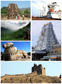 | |
|---|---|---|
| Regions | ||
| Districts | ||
| Million-plus cities | ||
| Cities (population over 1 lakh) | ||
| Tourism |
| |
| Related lists |
| |
| ||
| District headquarters |  | |
|---|---|---|
| Divisions | ||
| Mandals | ||
| Cities | ||
| Towns | ||
| Census towns | ||