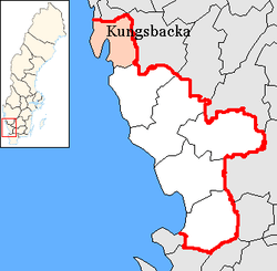
Kungsbacka Municipality
| Kungsbacka kommun | ||
|---|---|---|
| Municipality | ||
| ||
 | ||
| Country | Sweden | |
| County | Halland County | |
| Seat | Kungsbacka | |
| Area[1] | ||
| • Total | 1,472.94 km2 (568.71 sq mi) | |
| • Land | 606.67 km2 (234.24 sq mi) | |
| • Water | 866.27 km2 (334.47 sq mi) | |
| Area as of January 1, 2014. | ||
| Population (June 30, 2016)[2] | ||
| • Total | 79,702 | |
| • Density | 54/km2 (140/sq mi) | |
| Time zone | CET (UTC+1) | |
| • Summer (DST) | CEST (UTC+2) | |
| ISO 3166 code | SE | |
| Province | Halland | |
| Municipal code | 1384 | |
| Website | www.kungsbacka.se | |
| Density is calculated using land area only. | ||
Kungsbacka Municipality (Kungsbacka kommun) is a municipality in Halland County on the Swedish west coast, some 30 km south of Gothenburg. The municipal seat is located in the town Kungsbacka.
In 1969 Tölö was merged into the City of Kungsbacka. In 1971 the municipality was created when the city amalgamated with Särö. The final step was taken in 1974 when three more former municipalities were added to form the new entity.
Kungsbacka Municipality is closely integrated in the region of Metropolitan Gothenburg, but despite this it is administratively not a part of Västra Götaland County like the rest of the region.
A local geographical landmark is the glacial ridge Fjärås bräcka, to the south of Kungsbacka, but it is the coast that is the predominant geographical feature. The municipality receives its drinking water from the nearby lake Lygnern; the water undergoes a natural filtering process as it trickles through the ridge, contributing to its quality.
Localities
There are 22 urban areas (also called a tätort or locality) in Kungsbacka Municipality.
In the table the localities are listed according to the size of the population as of 31 December 2005. The municipal seat is in bold characters.
| # | Locality | Population |
|---|---|---|
| 1 | Kungsbacka | 17,784 |
| 2 | Onsala | 11,375 |
| 3 | Billdal 1) | 9,609 |
| 4 | Åsa | 3,218 |
| 5 | Särö | 2,982 |
| 6 | Fjärås kyrkby | 2,213 |
| 7 | Frillesås 2) | 1,924 |
| 8 | Backa | 1,516 |
| 9 | Vallda | 1,439 |
| 10 | Anneberg | 1,398 |
| 11 | Västra Hagen | 810 |
| 12 | Ölmanäs | 787 |
| 13 | Buerås | 556 |
| 14 | Halla Heberg | 509 |
| 15 | Lerkil | 411 |
| 16 | Gundal och Högås | 363 |
| 17 | Hagryd-Dala | 355 |
| 18 | Hjälmared | 341 |
| 19 | Brattås | 339 |
| 20 | Kläppa | 298 |
| 21 | Hjälm | 251 |
| 22 | Röda Holme | 201 |
1) Billdal is a bimunicipal locality. About 3,000 of the inhabitants are in Gothenburg Municipality.
2) A minor part of Frillesås is in Varberg Municipality.
References
- ↑ "Statistiska centralbyrån, Kommunarealer den 1 januari 2014" (Microsoft Excel) (in Swedish). Statistics Sweden. Retrieved 2014-04-18.
- ↑ "Folkmängd i riket, län och kommuner 30 juni 2016" (in Swedish). Statistics Sweden. August 17, 2016. Retrieved August 17, 2016.
External links
- Kungsbacka Municipality - Official site
Municipalities and seats of Halland County | ||
|---|---|---|
| Municipalities | ||
| Municipal seats | ||
Coordinates: 57°29′N 12°04′E / 57.483°N 12.067°E