Kumano River
| Kumano River | |
|---|---|
|
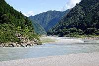
Kumano River at Shingū, Wakayama | |
| Native name | 熊野川 |
| Country | Japan |
| Basin | |
| Main source |
Mount Ōmine 1,719 m (5,640 ft) |
| River mouth |
Pacific Ocean 0 m (0 ft) |
| Basin size | 2,360 km2 (910 sq mi) |
| Physical characteristics | |
| Length | 183 km (114 mi) |
| Discharge |
|
The Kumano River (熊野川 Kumanogawa) is a river in the Kii Peninsula of central Japan, located in Nara, Wakayama and Mie Prefectures. It is 183 kilometres (114 mi) long and has a watershed of 2,630 square kilometres (1,020 sq mi).[1]
The river rises from Mount Ōmine in the Yoshino-Kumano National Park in Tenkawa, Nara and follows a generally southward course to drain into the Pacific Ocean on the border between Shingū, Wakayama and Kihō, Mie. The river is part of the Sacred Sites and Pilgrimage Routes in the Kii Mountain Range, a UNESCO World Heritage Site which incorporates nature scenery of the Kii peninsula with numerous Buddhist temples and Shinto shrines forming a pilgrimage route.
Municipalities through which the river passes are:
- Nara Prefecture
- Wakayama Prefecture
- Mie Prefecture
References
- Campbell,, Alan. editor (1993). Japan:An Illustrated Encyclopedia. Kodansha. ISBN 406205938X.
Notes
| Wikimedia Commons has media related to Kumanogawa. |
- ↑ Japanese Ministry of Internal Affairs (1961). Japan statistical yearbook, Vol.12. Nihon Tōkei Kyōkai.
Coordinates: 33°43′54″N 136°00′00″E / 33.73167°N 136.00000°E