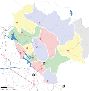
Kullu
| Kullu कुल्लू | |
|---|---|
| Town | |
 Kullu  Kullu Location in Himachal Pradesh, India | |
| Coordinates: 31°35′N 77°06′E / 31.58°N 77.10°ECoordinates: 31°35′N 77°06′E / 31.58°N 77.10°E | |
| Country |
|
| State | Himachal Pradesh |
| District | Kullu |
| Government | |
| • Type | Democratic |
| • Zonal Headquarters | Kullu |
| Elevation | 1,279 m (4,196 ft) |
| Population (2011) | |
| • Total | 18,306 (10th) |
| Languages | |
| • Official | Hindi |
| Time zone | IST (UTC+5:30) |
| PIN | 175101 |
| Telephone code | 01902 |
| Vehicle registration | HP 34 HP 66 |
| Sex ratio | 1.17 (1000/852) ♂/♀ |
| Website | www.hpkullu.gov.in |
Kullu or Kulu is the capital town of the Kullu district in the Indian state of Himachal Pradesh. It is located on the banks of the Beas River in the Kullu Valley about 10 kilometres (6.2 mi) north of the airport at Bhuntar.
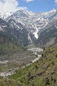
Kullu is a broad open valley formed by the Beas River between Manali and Largi. This valley is famous for its temples, beauty and its majestic hills covered with pine and deodar forest and sprawling apple orchards. The course of the Beas river presents a succession of magnificent, clad with forests of deodar, towering above trees of pine on the lower rocky ridges. Kullu valley is sandwiched between the Pir Panjal, Lower Himalayan and Great Himalayan Ranges.
History
Historical references about the Kullu valley dates back to ancient Hindu literary works of Ramayana, Mahabharata and the Puranas.[1] During Vedic period several small republics known as "Janapada" existed which were later conquered by the Nanda Empire, Mauryan Empire, Gupta Empire, Pala Dynasty and Karkoṭa Empire. After a brief period of supremacy by King Harshavardhana, the region was once again divided into several local powers headed by chieftains, including some Rajput principalities, these principalities were later conquered by Maratha Empire and Sikh Empire.[2]
The name Kullu derives from the word "Kulant Peeth", meaning "end of the habitable world". As per legends, during the Great Flood, Manu visited this valley, but was unable to cross the Rohtang pass. He named the last settlement he found as Kulant Peeth, and chose to settle and meditate in what has now become the town of Manali (Manu's Place). The name further devolved into "Kulut", as the kingdom was known for a long time; before finally being known by the current name of Kullu or Kulu.
The Buddhist pilgrim monk Xuanzang visited the Kullu Valley in 634 or 635 CE. He described it as a fertile region completely surrounded by mountains, about 3,000 li in circuit, with a capital 14 or 15 li in circumference. It contained a Stupa built by Mauryan Emperor Ashoka, which is said to mark the place where the Buddha preached to the local people and made conversions, Stupa was taken away by a Mughal ruler and put in feroz shah kotla maidan in Delhi. There were some twenty Buddhist monasteries, with about 1,000 monks, most of whom were Mahayanist. There were also some fifteen Hindu temples, and people of both faiths lived mixed together. There were meditation caves near the mountain passes inhabited by both Buddhist and Hindu practitioners. The country is said to have produced gold, silver, red copper, crystal lenses and bell-metal.[3]
Kullu got its first motorable access only after Indian Independence. The long centuries of seclusion have, however, allowed the area to retain a considerable measure of its traditional charm. The road through the Kullu Valley and Lahaul is now paved all the way, to connect and provide the major access route between the northern Indian plains to Leh in Ladakh.
Geography
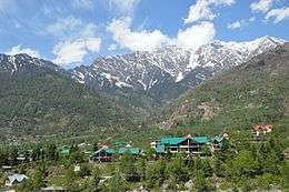
Kullu town has an average elevation of 1,278 m (4,193 ft). It lies on the bank of Beas River. A major tributary, Sarvari, (derived from "Shiv-Baardi") leads to the less explored and steeper Lug-valley on the west. On the east of Kullu lies a broad mountainous ridge having the village-temples of Bijli Mahadev, Mounty Nag and Pueed. Beyond the ridge lies Manikaran valley, along the Paarvati river which joins Beas at Sangam in Bhuntar. On the south of Kullu lie the town of Bhuntar, Out (leading to Anni, Banjar and Siraj Valley) and Mandi (in Mandi district). Historically Kullu was accessible from Shimla via Siraj valley or through passes on the west leading to Jogindernagar and onto Kangra. To the north lies the famous town of Manali, which through the Rohtang pass leads onto the Lahaul and Spiti Valley. Once can see an enormous change in the climate as one climbs up the windward side of the ranges to proceed to the leeward and much drier plateaus to the north of Manali.
The valley has varied biodiversity, It has some of the rarest of animals like Himalayan tahr, western tragopan, monal and Himalayan brown bear. The Great Himalayan National Park (GHNP) is also located here. The park was built in 1984. It spreads over an area of 1,171 km2 (452 sq mi) which lies between an altitude of 1,500 to 6,000 m (4,900 to 19,700 ft). In order to protect the flora and fauna of this Himalayan area, many places are declared as wildlife sanctuaries, such as: Khokhan Sanctuary, Kais Sanctuary, Tirthan Sanctuary, Kanawar Sanctuary, Rupi Baba Sanctuary, Great Himalayan National Park and Van Vihar Manali.
Demographics
As of 2011 India census,[4] Kullu had a population of 18,306. Males constitute 54% of the population and females 46%. Kullu has an average literacy rate of 81%, higher than the national average of 59.5%: male literacy is 84%, and female literacy is 77%. In Kullu town, 10% of the population is under 6 years of age.
Administrative
Kullu town, as the administrative headquarters of Kullu district, has the offices of Deputy Commissioner, the Superintendent of Police and the District courts. It is also the largest and the most varied constituency of Lok Sabha, the lower house of the parliament of India.
Climate

December and January during winter observe lowest temperatures ranging from −4 to 20 °C (25 to 68 °F), with some snowfall.Evenings and mornings are very cold during winters. Annual highest temperature in summer ranges from 24 to 34 °C (75 to 93 °F) during May to August. Months of July and August are rainy because of monsoon, having around 150 mm (5.9 in) rainfall monthly. Climate is pleasant in October and November.
Air
The nearest airport (IATA code KUU) is at Bhuntar town, situated on NH21 at the confluence of the Parvati and Beas rivers (latitude 31.8763 N and longitude 77.1541 E), about 10 km (6.2 mi) south of Kullu town. The airport is also known as Kullu-Manali airport and has a runway more than a kilometre long. Indian Airlines and some private airlines have regular flights to the airport. Himalayan Bulls in collaboration with Deccan Charters started flights on Kullu-Chandigarh-Kullu sector beginning 2 April 2014 with 2 to 3 unscheduled flights each day in eight-seater planes.
Chandigarh airport is the nearest large airport.
Road
Kullu can be reached from Delhi by national highway NH 1 up to Chandigarh and from there by national highway NH21 that passes through Bilaspur, Sundernagar and Mandi towns. The road distance from Delhi to Chandigarh by bus[5] is 260 km (160 mi) and from Chandigarh to Kullu[6] is 252 km (157 mi); the total distance from Delhi to Kullu[7] thus is about 512 km (318 mi).
Rail
Kullu is not easily approachable by rail. The nearest broad gauge railheads are at Una and Kiratpur Sahib (Both 200 kilometres (120 miles) away), Kalka 240 kilometres (150 miles) away, Pathankot 275 kilometres (171 miles) away, and Chandigarh (280 kilometres (170 miles). The nearest narrow gauge railhead is at Joginder Nagar (100 km [62 mi]) away.
Attractions
The Kullu valley is known as the "Valley of the Gods" or "Dev Bhumi" due to many pilgrimage sites for Hindus, Buddhists and Sikhs alike.[8] Kullu is known for its open valley meadows and scenic views of the Himalayan mountain range. Kullu area is known for Kullu shawl, made of many natural fibers including pashmina, sheep-wool and angora. The seven-day festival of Kullu Dussehra, a celebration of Avatar Lord Rama's victory over the evil king Ravana. The festival takes place in the months of October or November, depending upon the Hindu calendar.
Sightseeing
- Raghunath Temple - In the 17th century, Raja Jagat Singh of Kullu committed a great mistake. To atone for the sin, he sent a senior courtier to Ayodhya for a statue of Lord Raghunath - Lord Rama. This temple was built by Raja Jagat Singh to house the image and even today, is greatly revered. Every year international fair Dussehra is celebrated with local deities in honour of lord Raghunath.
- Shringi Rishi Temple- Banjar - About 60 km. from Kullu is Banjar valley wherein Shringi Rishi Temple is located. Shringi Rishi is the ruling deity of Banjar valley. In fact, before the Lord Rama's advent into Kullu valley from Ayodhya Puri,Lord Shringi was the ruling deity of Kullu. Shringi rishi is one among the "atthara kardoo" (eighteen chief deities) of the Kullu valley.
- Maha Devi Tirth Temple - Shri Mahadevi Tirth, popularly known as Vaishno Devi Mandir (by localities), situated about two kilometers North from the Kullu valley on Kullu Manali road, though a newly founded temple, yet it is acknowledged like any old famous temple. The foundation of this temple was laid by [Swami Sewak Das Ji].
- Bijli Mahadev Temple - It is located at 2,435 meters from sea level and is about 10 km from Kullu. The staff of the temple is 60 feet high and can be seen from the Kullu valley too. It is the highest point around Kullu from where the beautiful view of the whole town, and more can be experienced.
- Devta Narsingh - A famous temple of deity 'Narsingh', situated in Sultanpur block of Kullu.
- Raison - By the banks of the Beas -and on the Kullu-Manali highway - Himachal Tourism runs a camping site here. Ideal for a taste of adventure.
- Shoja - At 2692 m, this is a vantage point for a complete panorama of the Kullu area - snow peaks and valleys, meadows and forests, rivers and streams. From Shoja, Jalori pass is 5 km far from where you can take an extreme view of Shoja and its vicinity. From some distance from Jalori you can visit a lake named Sareuolsar. It is an extraordinary place to visit but there is no means of transportation so you have to go on foot.
- Basheshwar Mahadev Temple, Bajaura - One of the most charming temples in the Kullu valley, this is renowned for its intricate stone carvings. It is said to be built by pandavas.
- Kasol - An open glade by the banks of the river Parvati. Clean white sand separates the lush green grass from the water. A good spot for trout. Himachal Tourism has a Tourist Hut here.
- Naggar - For 1400 years this was the capital of Kullu. Its 16th century stone and wood castle is now a hotel run by Himachal Tourism. Here, a gallery houses the paintings of the Russian artist, Nicholas Roerich. Naggar also has three other old shrines.There are many old pagoda shali temple also there.
- Hidimba temple- dungri,Manali.
- Kais Dhar - An immensely beautiful place, with grass meadows and densely forested mountains. It is a part of trekking route and is not connected through road, hence the natural beauty is still preserved. It is easily one of the most beautiful places in Himachal. This place has a forest rest house which was built by Britishers, who liked this place. It not far away from Kullu town, approximately 10 km from the town. But it is not connected through road.
FUNGANI MATA TEMPLE-this lies on the top of the lugvalley. This is really a beautiful place and still hidden from tourist hence still the area around this us preserved. Temple is near about 30 km away from kullu town. while road is Only up to base of the point from where there is little walk to the temple.
Festivals and other activities
- Kullu Dussehra - When Dussehra celebrations come to an end in the rest of the country, they begin at Kullu. The State government has accorded the status of International festival to the Kullu Dussehra, which attracts tourists in large numbers. About 200 local deities come to pay homage to Lord Raghunath.[9] This is a time when the valley is at its colourful best.
- Kullu Holi - Holi is the festival of colors celebrated for two days in Kullu.Its unique feature is that people of the town collect in temple and then they proceed to houses of town people singing sacred holi songs and in return they are given sweets,pakoras and hard drinks etc. Women also take part in the festival with same enthusiasm and happiness as Men.
- Fishing and adventure - The Kullu valley has numerous places for trout fishing. These include Katrain, Raison, Kasol and Naggar, then along the river Tirthan near Larji, in the Sainj Valley and in the Hurla khud. The valley is the nucleus of several trek routes. Some major ones are over the Chanderkhani Pass to Malana, over the Jalori Pass or Bashleo Pass to Shimla, and over the Pin Parvati Pass to Sarahan. White water rafting is popular on the Beas river.[10] Rapid Riders is one of the oldest service providers in kullu offering commercial white water rafting on the 16 km river course.
It connects with the Lahul and Spiti valleys via Rohtang Pass, situated at 3,978 m (13,051 ft) 51 km (32 mi) from Manali city.
Vicinity
Other places of interest in the area include Manikaran which is famous for its hot springs, and hot water springs at Vashisht village near Manali, 40 km north of Kullu, a hub for tourists and rock climbers. Malana, Kaish-Dhaar in Lug Valley, Bijli Mahadev, Bhekhli and Bajaura house the famous temples of the region and places like Kasol and Gohar. Manali is perhaps the most famous town and center of all tourist attractions in the state. Manali also has a well-known temple dedicated to the mythical princess Hidimba. which is known as Hidimba Devi Temple.
The economy of the town largely depends on tourism, horticulture (apples,[11] plums, pears, and almonds) and handicrafts (shawls, caps, etc.).[12] A majority of the youth depend on tourism for their well being, which has led to construction of a large number of hotels by locals such as the Himalayan Hamlet, Shivalik, Tree House, Apple Valley and Raju Bharti.
 Shiva shrine, Kullu
 Himalayas from the Kullu Valley
 Roerich's family, Kullu valley
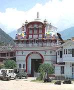 Raja Rupi Kulu Palace
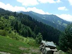 Kais Dhar
 Kais Dhar Medows
References
- ↑ http://himachal.gov.in/index1.php?lang=1&dpt_id=200&level=1&lid=8449&sublinkid=8216
- ↑ Verma 1995, pp. 28–35, Historical Perspective.
- ↑ Watters (1904-1905), pp. 298, 335.
- ↑ "Census of India 2001: Data from the 2001 Census, including cities, villages and towns (Provisional)". Census Commission of India. Archived from the original on 2004-06-16. Retrieved 2008-11-01.
- ↑ http://www.distancesbetween.com/bus/bus-tickets-from-delhi-to-chandigarh/1427
- ↑ http://www.distancesbetween.com/bus/bus-tickets-from-chandigarh-to-kullu/1299
- ↑ http://www.distancesbetween.com/bus/bus-tickets-from-delhi-to-kullu/1414
- ↑ "Valley of the Gods". IGNCA. Retrieved 2007-03-26.
- ↑ International Dussehra festival kicks off at Kullu, The Indian Express, 11 October 2008. Retrieved 6 October 2011.
- ↑ http://www.rapidriders.in/rafting.html
- ↑ "Agriculture - Horticulture". kullu.net. Retrieved 2015-11-22.
- ↑ "Kinnaur: Land of Gods, Kullu Shawls & Untold Adventures". AlienAdv Blog. Retrieved 2015-11-22.
Further reading
- Francke, A. H. (1914, 1926). Antiquities of Indian Tibet. Two Volumes. Calcutta. 1972 reprint: S. Chand, New Delhi.
- Hutchinson, J. & J. PH Vogel (1933). History of the Panjab Hill States, Vol. II. 1st edition: Govt. Printing, Pujab, Lahore, 1933. Reprint 2000. Department of Language and Culture, Himachal Pradesh. Chapter X Kulu State, pp. 413–473.
- Watters, Thomas. (1904–1905): On Yuan Chwang’s Travels in India. 1904-1905. London. Royal Asiatic Society. Reprint: Delhi. Munshiram Manoharlal. 1973.
External links
| Wikimedia Commons has media related to Kullu. |
- Kullu Manali Tourism
- Kullu Himachal Pradesh Tourism Guide
- News and videos of Kullu
- Website gives details information about kullu valley
- Himachal Tourism website
- Malana, IGNCA archive
- Kullu Travel guide to Kullu | Himachal Pradesh | India | location | distances | weather & climate | travel tips | tourist places | photos | and more.
- International Roerich Memorial Trust