Crown Prince Christian Land
| Kronprins Christian Land | |
|---|---|
 Location of Crown Prince Christian Land | |
| Geography | |
| Location | Far Northeast Greenland |
| Coordinates | 80°52′N 18°45′W / 80.867°N 18.750°WCoordinates: 80°52′N 18°45′W / 80.867°N 18.750°W |
| Adjacent bodies of water | |
| Length | 213 km (132.4 mi) |
| Width | 115 km (71.5 mi) |
| Administration | |
|
Greenland (Denmark) | |
| Zone | Northeast Greenland National Park |
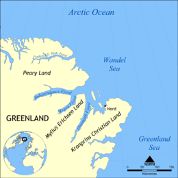
Crown Prince Christian Land (Danish: Kronprins Christian Land) is a large peninsula in northern Greenland named after Crown Prince Christian, later Christian X of Denmark. It is a part of Northeast Greenland National Park.
Geography
Crown Prince Christian Land extends 100 km NE from Cape Jungersen. It is surrounded to the north by the Wandel Sea of the Arctic Ocean, to the east by Fram Strait, to the south by the Ingolf Fjord and the Greenland Sea, and to the west by the Greenland Ice Sheet.[1] The southeastern part of the peninsula is known as Amdrup Land. The outer part of Crown Prince Christian Land is almost totally covered by the Flade Isblink ice cap.[2]
Romer Lake, famous for its striking Elephant Foot Glacier, is a long and narrow lake running parallel to Denmark Fjord at the western end of the peninsula to the west of the Princess Elizabeth Alps.[3] Princess Dagmar Island lies off its northwestern shores. The Danish military base/weather station Nord is its only settlement.
 Map of Kronprins Christian Land's northern half. |
 View of the Elephant Foot Glacier at Romer Lake. |
References
- ↑ Kronprins Christian Land
- ↑ Prostar Sailing Directions 2005 Greenland and Iceland Enroute, p. 128
- ↑ "Romer Sø". Mapcarta. Retrieved 16 June 2016.