Krokskogen
.jpg)
Krokskogen in winter
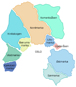
Krokskogen forms part of Oslomarka
Krokskogen is a forested area which located outside of Oslo, Norway. It is a part of Oslomarka and is situated between Bærumsmarka, Vestmarka and Nordmarka.[1]
The wooded and hilly area of around 300 square kilometres is bordered by Oslo and by the municipalities of Ringerike, Hole and Bærum. The highest points in the landscape are Oppkuven (704 m.), Ringkollen (702 m) and Gyrihaugen (682 m). The old road through Krokskogen which opened in 1805 was part of the King's Road (Ringeriksveien) from Oslo to Bergen. It is now mostly used as a hiking and bridal trail in season and for timber transport during the winter.[2][3][4]
References
- ↑ Geir Thorsnæs. "Krokskogen". In Henriksen, Petter. Store norske leksikon (in Norwegian). Oslo: Kunnskapsforlaget. Retrieved 4 February 2010.
- ↑ Geir Thorsnæs. "Oppkuven". Store norske leksikon. Retrieved October 1, 2016.
- ↑ Geir Thorsnæs. "Ringkollen". Store norske leksikon. Retrieved October 1, 2016.
- ↑ Geir Thorsnæs. "Gyrihaugen". Store norske leksikon. Retrieved October 1, 2016.
Other sources
- Grimstad, Sverre (2007) Krokskogen på kryss og tvers (topografisk forl) ISBN 9788279810391
This article is issued from Wikipedia - version of the 12/3/2016. The text is available under the Creative Commons Attribution/Share Alike but additional terms may apply for the media files.