Krivošije

Krivošije (pronounced [kriv̞ɔ̌ʃijɛ], Montenegrin: Кривошије) is a historical tribe and sub-region of Old Herzegovina, a high plateau on the eastern branches of Mount Orjen (1894 m) in Montenegro, north of the Bay of Kotor. Krivošije is located at the historical tripoint between the Principality of Montenegro, Austro-Hungarian (formerly Venetian) Bay of Kotor and Sanjak of Herzegovina.[1]
Name
In Serbian language, krivi (in masculine, neutral krivo) means "bent" or "crooked", while šije (singular: šija) means "necks", and it may be derived from some ancestor with a deformity. It might also be derived from the Serbian word krv meaning blood, as in linked by blood relationships.
Geography

Krivošije is a mountainous karst region above Risan, at ca. 1000 m above sea.[1] It includes 114 km2 of land.[1] It is a high plateau on the eastern branches of Mount Orjen (1894 m) in south Montenegro, near Kotor. A significant geological and geomorphological feature of the region are the glacial deposits distributed across the whole of the plateau. They were deposited by valley glaciers coming from Orjen during the Ice Age. Krivošije is the region with the greatest rainfall in Europe.
Settlements in the region include Crkvice (Gornje and Donje), Dragalj, Han, Malov Do, Knežlaz, Poljice and Zvečava.
History
The region came under Venetian rule after the Cretan War (1645–69). The Bay of Kotor, part of Venetian Albania, was also called "Upper Dalmatia". The first mention of Krivošije is from a Venetian report dated 1686, in which 15–20 houses are mentioned in the village.
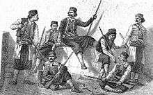
Krivošije was under Austro-Hungarian control (as part of the Kingdom of Dalmatia) since the Congress of Vienna in 1814.[2] In 1869 an uprising of the local population, which was Serb and Orthodox, defeated an expedition force of the powerful Austro-Hungarian army that was attempting to enforce compulsory military service; Austria-Hungary abandoned its efforts, for now. Volunteers from the region joined the Serb rebels in the Herzegovina Uprising (1875–77).[3] Austro-Hungarian forces returned in 1881, defeating the rebels. Austria-Hungary immediately began to pacify the region with heavy investment in tremendous fortifications that would make the military harbour in the gulf safe from Montenegrin and Russian aspirations.
During World War II, Krivošije was a Chetnik stronghold.[4] Local merchant Miloš Kovač organized an armed band of 80 men in Krivošije which threatened Yugoslav Partisan access and control in the region.[5] Two Partisan detachments were established in Krivošije under the KPJ Herceg-Novi.[6] In September 1944, the battles of the 10th Montenegrin NOV brigade in Krivošije had the largest echo in the Bay of Kotor and Paštrovići.[7]
Culture
The krsna slava (feast day) of the brotherhoods is St. John the Baptist (called Jovanjdan), on 20 January.
- Church of St. Petka in Poljice, built in the second half of the 17th or 18th century.[8]
- Pokrov Bogorodice in Dragalj, built in 1867.[9]
- Roždestvo Bogorodice in Malov Do, built in 1831.[9]
- Church of St. John in Zvečava, built in the second half of the 17th century.[9]
References
- 1 2 3 Luković 1951, p. 96.
- ↑ Kostić 1970, p. 92.
- ↑ Ćosović 2005, p. 82.
- ↑ Vojnoistorijski institut 1963, p. 15.
- ↑ Vučetić 1947, p. 46.
- ↑ Vojnoistorijski institut 1963, p. 11.
- ↑ Vojnoistorijski institut 1963, p. 6.
- ↑ Nikolić 2003.
- 1 2 3 Nikolić 2004.
Sources
- Ćosović, Stevo (2005). Славно доба Херцеговине: спомен-књига о Херцеговачком устанку 1875-1878. Svet knjige.
- Đorđević, Vladan (1924). Црна Гора и Аусгрија 1814 — 1894. Belgrade.
- Kostić, Lazo M. (1961). O srpskom karakteru Boke Kotorske. Sfairos.
- Kostić, Lazo M. (1970). Stogodišnjica I [i.e. prvog] Krivošijskog ustanka, 1869-1969: istorijska i pravna rasprava. Iskra.
- Luković, Niko (1951). Boka Kotorska: kulturno-istoriski vođ. Narodna knjiga.
- Mijušković, Slavko (1970). Ustanak u Boki Kotorskoj 1869. Centar za kulturu.
- Radojičić, Dragana (2006). Између култура Истока и Запада: северозападна Бока Которска. Etnografski institut SANU. ISBN 978-86-7587-037-1.
- Radojičić, Lazar B. (1934). Кривошије и Кривошијани: Њихова буна, борба и рат за ослобођење 1869 год. у борби против Аустро-мађарског царства. Nikšić: Slobodna misao.
- Vojnoistorijski institut (1963). Vojno-istoriski glasnik. 14. Belgrade: Vojnoistorijski institut.
- Vučetić, Stevan J. (1947). Građanski rat u Crnoj Gori, 1941-1945. Crnogorski prosvetni klub.
External links
- Karadžić, Vuk (1972) [1849]. "Бока Которска". Nolit; Rastko.
- Nikolić, Katarina (2003). "Црквени споменици на подручју Кривошија и Леденица (I део)". БОКА. Rastko.
- Nikolić, Katarina (2004). "Црквени споменици на подручју Кривошија и Леденица (II део)" (PDF). БОКА. Rastko.
- "Кривошије заробљене у беспућу". Politika. 2008.
|  | |
Coordinates: 42°33′N 18°39′E / 42.55°N 18.65°E
| Wikimedia Commons has media related to Krivošije. |