Kristinestad
| Kristinestad Kristinestad – Kristiinankaupunki | ||
|---|---|---|
| Town | ||
| Kristinestads stad Kristiinankaupungin kaupunki | ||
 | ||
| ||
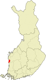 Location of Kristinestad in Finland | ||
| Coordinates: 62°16′N 021°21′E / 62.267°N 21.350°ECoordinates: 62°16′N 021°21′E / 62.267°N 21.350°E | ||
| Country | Finland | |
| Region | Ostrobothnia | |
| Sub-region | Suupohjan rannikkoseutu | |
| Founded | 1649 | |
| Government | ||
| • City manager | Riitta El-Nemr | |
| Area (2011-01-01)[1] | ||
| • Total | 1,678.98 km2 (648.26 sq mi) | |
| • Land | 682.53 km2 (263.53 sq mi) | |
| • Water | 996.45 km2 (384.73 sq mi) | |
| Area rank | 58th largest in Finland | |
| Population (2016-03-31)[2] | ||
| • Total | 6,798 | |
| • Rank | 147th largest in Finland | |
| • Density | 9.96/km2 (25.8/sq mi) | |
| Population by native language[3] | ||
| • Swedish | 56.6% (official) | |
| • Finnish | 42.2% (official) | |
| • Others | 1.2% | |
| Population by age[4] | ||
| • 0 to 14 | 12.4% | |
| • 15 to 64 | 62.8% | |
| • 65 or older | 24.7% | |
| Time zone | EET (UTC+2) | |
| • Summer (DST) | EEST (UTC+3) | |
| Municipal tax rate[5] | 20% | |
| Website | www.kristinestad.fi | |
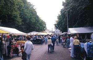
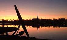
Kristinestad (Finnish: Kristiinankaupunki) is a town and a municipality in Finland. It is located in the western part of Finland on the shore of the Bothnian Sea. The population of Kristinestad is 6,798 (31 March 2016)[2] and the municipality covers an area of 682.53 km2 (263.53 sq mi) (excluding sea areas) of which 14.66 km2 (5.66 sq mi) is inland water (1 January 2011).[1] The population density is 9.96/km2 (25.8/sq mi). The population is bilingual with a majority speaking Swedish (57%) and the minority Finnish (42%).[3] The town was chartered in 1649 at Koppö island and is named for Queen Christina of Sweden. Kristinestad is known for its old town with low wooden houses and narrow alleys. In April, 2011, Kristinestad became Finland's first Cittaslow community.
International relations
Twin towns — Sister cities
Kristinestad is twinned with:
Climate
Kristinestad has a continental subarctic (Dfc) climate.
| Climate data for Kristinestad | |||||||||||||
|---|---|---|---|---|---|---|---|---|---|---|---|---|---|
| Month | Jan | Feb | Mar | Apr | May | Jun | Jul | Aug | Sep | Oct | Nov | Dec | Year |
| Daily mean °C (°F) | −8 (18) |
−7.8 (18) |
−3.7 (25.3) |
1.9 (35.4) |
9 (48) |
14 (57) |
15.7 (60.3) |
13.8 (56.8) |
8.8 (47.8) |
4.0 (39.2) |
−1.3 (29.7) |
−5.6 (21.9) |
3.4 (38.12) |
| Average precipitation days | 10 | 8 | 9 | 8 | 7 | 8 | 11 | 11 | 11 | 11 | 11 | 11 | 116 |
References
- 1 2 "Area by municipality as of 1 January 2011" (PDF) (in Finnish and Swedish). Land Survey of Finland. Retrieved 9 March 2011.
- 1 2 "Ennakkoväkiluku sukupuolen mukaan alueittain, maaliskuu.2016" (in Finnish). Statistics Finland. Retrieved 31 March 2016.
- 1 2 "Population according to language and the number of foreigners and land area km2 by area as of 31 December 2008". Statistics Finland's PX-Web databases. Statistics Finland. Retrieved 29 March 2009.
- ↑ "Population according to age and gender by area as of 31 December 2008". Statistics Finland's PX-Web databases. Statistics Finland. Retrieved 28 April 2009.
- ↑ "List of municipal and parish tax rates in 2011". Tax Administration of Finland. 29 November 2010. Retrieved 13 March 2011.
External links
![]() Media related to Kristinestad at Wikimedia Commons
Media related to Kristinestad at Wikimedia Commons
- Official website (Swedish) (Finnish) (English) (German)
 Kristinestad travel guide from Wikivoyage
- Kristinestad 1649–1999. One of the best preserved wooden towns in Fenno-Scandinavia

| Municipalities |  | |
|---|---|---|
| Former municipalities | ||