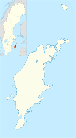
Kräklingbo
| Kräklingbo | |
|---|---|
|
Käklingbo church | |
 Kräklingbo | |
| Coordinates: 57°26′42″N 18°42′41″E / 57.44500°N 18.71139°ECoordinates: 57°26′42″N 18°42′41″E / 57.44500°N 18.71139°E | |
| Country | Sweden |
| Province | Gotland |
| County | Gotland County |
| Municipality | Gotland Municipality |
| Population (2014)[1] | |
| • Total | 202 |
| Time zone | CET (UTC+1) |
| • Summer (DST) | CEST (UTC+2) |

Kräklingbo is a settlement on the Swedish island of Gotland. Formerly a socken,[2] on 1 January 2016, it was reconstituted into the administrative area Kräklingbo District.[3] The most visible feature at Kräklingbo is the Torsburgen, a fortified plateau. In 1992, it was the site of a large wildfire.
Geography
Kräklingbo is the name of the socken, now district. It is also the name of the small village surrounding the medieval Kräklingbo Church,[4] sometimes referred to as Kräklingbo kyrkby. It is situated near the central part of Gotland's east coast.[5]
Farms
Kräklingbo consist of a number of farms over a larger area.[6]
|
|
Etymology
The name Kräklingbo dates from the 15th century, and was originally the name of a farm. The first part of the name (Kräkling) probably means "dry hook" as in dry twig or fork of a bough, the second part (bo) is old Swedish for "settlement".[7][8]
One of the asteroids in the Asteroid belt, 8682 Kräklingbo, is named after this place.[9]
History
The most visible feature at Kräklingbo is the ancient fortress of Torsburgen, a fortified plateau towering above the rest of the landscape.[6][10] Nearby, at Hajdeby farm, there are a number of visible Bronze Age grooves.[11]
The great forest fire
The Gotland wildfire of 1992, sometimes called the Kräklingbo fire, started early in the morning on 9 July 1992 in the forest in the southern part of Torsburgen. It is one of the largest ancient fortresses in Sweden.[12] Although no one died in the fire, it developed into one of the largest wildfires in Sweden.[13] The fire destroyed vegetation over an area of more than 1,000 ha (2,500 acres), of which 740 ha (1,800 acres) was productive forest land.[14] The fire resulted in one of the biggest rescue operations in modern times on Gotland.[15]
Wildfire
The early summer of 1992 was unusually warm with little rain, leaving the ground extremely dry.[16] On 9 July there was a moderate gale of about 7 on the Beaufort scale, coming from the south. The fire, probably started by a burning cigarette,[17] started in the southern part of Torsburgen, a couple of hundred meters north of the Arde opening.[6] The fire spread rapidly and soon developed into a canopy fire. Due to the wind a fire storm, about two kilometers wide, formed and advanced north toward Hajdeby farm and Kräklingbo church.[14] The fire had three fronts. Two flanks, each approximately 6 km (3.7 mi) wide, slowly spreading outwards and a 2.5 km (1.6 mi) wide front advancing very rapidly in the north.[14]
Suppression

A day later, on the morning of 10 July, the fire was 1 km (0.62 mi) wide and about 5 km (3.1 mi) long. On site were approximately one hundred firefighters, sixty enlisted soldiers from the P 18 regiment in Visby and some volunteers.[18] A command centre was established at Kräklingbo fire station. Helicopter Q 90 with crew from Visby also participated in suppressing the fire. Later on another helicopter, the Q 97 with a hastily formed crew, joined the operation as did helicopter Q 91. These three helicopters logged a total of 43 hours and 45 minutes in flight during the fire. They dropped 414 tanks, about 800 cubic metres (28,000 cu ft), of water.[19]
During the day the fire advanced on the three farms at Hejdeby while the rescue command prepared to evacuate all residents in the area. There was a great deal of confusion about what to do until Nisse Olofsson, a former chief at the Kräklingbo fire station, more or less took over the fire suppression at Hejdeby with the help of about 20 volunteers.[18] They succeeded in establishing a counter fire and stopped the main blaze just 10 m (33 ft) from Tors farm. At this time the flames were approximately 30 m (98 ft) high.
On the evening of 11 July, firebreaks had been established around the area, but the fire continued to rage inside.[14]
On the morning of 13 July, the local radio station broadcast an announcement requesting all firefighters on vacation to report at the Visby fire station.[18] Later it was announced that the worst stage of the fire had passed as a light rain fell on Gotland suppressing the fire. During the night the firefighters had also gone into the Torsburgen and conducted intense work to prevent the fire from spreading further within that area, but they were forced to retreat due to falling trees. About fifty firefighters now monitored the south part of Torsburgen and the fire was declared to be under control.[18]
By this time, the police had trouble keeping away curious people gathering in the area. Even families with children had gone into the fire site despite warnings on local radio to respect the cordons and the risk of falling trees.[18]
Aftermath

Suppression of the fire was the largest rescue operation on Gotland in modern times. The post–fire work continued for several years .[18] The fire destroyed more than 1,000 ha (2,500 acres) of land. About 740 ha of these were productive forest land in the Kräklingbo and Gammelgarn area (total value of 20 million crowns, about US$3 million)[17] and 41 land owners were affected.[14] Nearly all of the forest in the central and north part of Torsburgen was more or less destroyed by the fire. It was more than a month later that the Rescue Department declared the operation finished. The total cost of the rescue operation was about 18.5 million crowns (about US$2.85 million)[20] The Swedish Armed Forces contributed with 400 military personnel, communication equipment, helicopters and vehicles.[21]
The fire in 1992, was by no means the first on the Torsburgen. In the summer of 1741, when Carl Linnaeus visited the fortress, he noted that it was almost without trees, "since wildfire had not so long ago destroyed it".[22] The "wildfire" he spoke of was probably the large forest fire of 1655, which raged during that summer destroying parts of Alskog, Ala, Ardre and Kräklingbo parishes.[6]
Gallery
 South Hajdeby, Kräklingbo.
 Tomb stone at Kräklingbo church.
 Paintings in Kräklingbo church.
 Ardre opening at Torsburgen, Kräklingbo.
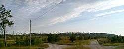 Torsburgen from a distance, Kräklingbo.
 Grooves at Torsburgen, Kräklingbo.
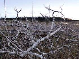 Torsburgen after the fire
References
- ↑ "Gotland i siffror 2015" [Gotland in numbers 2015]. www.gotland.se. Gotland Municipality. Retrieved 25 May 2016.
- ↑ The exact extent of the socken, now district, can be obtained by clicking on Kartinställningar and check the Socken box in the menu of this map from the Swedish National Heritage Board database.
- ↑ "Förordning om district" [Regulation of districts] (PDF). Ministry of Finance. 17 June 2015. Retrieved 24 May 2016.
- ↑ Lagerlöf, Erland; Svahnström, Gunnar (1973). Gotlands kyrkor [Gotland's Churces] (in Swedish). Stockholm: Rabén & Sjögren. pp. 187–190. ISBN 91-29-41035-5. LIBRIS 7232718.
- ↑ "Kräklingbo". www.ne.se. Nationalencyklopedin. Retrieved 27 May 2016.
- 1 2 3 4 "Torsburgen naturreservat". Website. Guteinfo.com. Retrieved 29 May 2014.
- ↑ Wahlberg, Mats (2003). Svenskt ortnamnslexikon. Uppsala: Institutet för språk och folkminnen. Stockholm: Wahlström & Widstrand. ISBN 91-7229-020-X.
- ↑ "Kräklingbo". Website/encyclopedia. Nationalencyklopedin. Retrieved 30 May 2014.
- ↑ "JPL Small-Body Database Browser". NASA. Retrieved 2008-05-04.
- ↑ Engström, Johan (1987). Torsburgen: a guide. Romakloster: Tors bod.
- ↑ "RAÄ-nummer Kräklingbo 52:1". Data base. Swedish national heritage board. Retrieved 29 May 2014.
- ↑ Carlquist, Gunnar (1955). Josef Carlsson, ed. Svensk uppslagsbok (in Swedish). Malmö: Förlagshuset Norden. p. 685.
- ↑ Räddningsverket. "Fakta: Stora skogsbränder, 16 August 2006.". Website / Newspaper. Göteborgsposten. Retrieved 29 May 2014.
- 1 2 3 4 5 Linné, Ingemar. "Den gotländska skogens historia" (PDF). PDF. Skogsstyrelsen. Retrieved 29 May 2014.
- ↑ Gyllin, Pia. "Torsburgen – unik mitt i katastrofen". Website. Skogsaktuellt. Retrieved 29 May 2014.
- ↑ "Torsburgen". Website. Länssyrelsen Gotlands län. Retrieved 29 May 2014.
- 1 2 TV3, Larmet går–Skogsbrand på Gotland 1993.
- 1 2 3 4 5 6 "Arkivet 30 år från 1992, 10 juli". Data base. SR Gotland. Retrieved 10 February 2009.
- ↑ Persson, Carl-Olof. "Statistik från räddningsuppdrag". Website. Nålstens vänner. Retrieved 29 May 2014.
- ↑ Arvidsson, Lillemor (20 July 2000). "Samutnyttjande av resurser på Gotland". Länstyrelsen i Gotlands län: 24. Retrieved 10 February 2009.
- ↑ Civil-military samverkan på central nivå, p.48, Totalförsvarets forskningsinstitut, October 2003.
- ↑ Linné, Carl von (1991). Carl Linnæi Öländska och gotländska resa på riksens höglovlige ständers befallning förrättad år 1741 (in Swedish). Stockholm: Wahlström & Wistrand. ISBN 91-46-16035-3.
Further reading
- Andersson, Yvonne (1995). Kräklingbo socken förr och nu. Bromma: Y Andersson. ISBN 91-630-3228-7. LIBRIS 7450480.
- Svensson, Torsten; Vasilyeva, Svetlana (2011). Kräklingbo kyrka och bygd: utgiven till 800-årsminnet av kyrkans invigning. Enskede: Oeisspeis. ISBN 978-91-978956-5-1. LIBRIS 12478888.
- Engström, Johan (1984). Torsburgen: tolkning av en gotländsk fornborg = [Torsburgen] : [interpretation of a Gotlandic hillfort]. Uppsala: Inst. för arkeologi, Univ. (distr.). ISBN 91-506-0571-2. LIBRIS 7402526.
- Larsson, Gustaf (1967). Gutniska dikter (2 ed.). Kräklingbo: Gustaf Larsson. LIBRIS 1799836.
External links
| Wikimedia Commons has media related to Kräklingbo. |
