Kotor Varoš
| Kotor Varoš Котор Варош | ||
|---|---|---|
 | ||
| ||
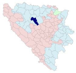 Location of Kotor Varoš within Republika Srpska, Bosnia and Herzegovina | ||
| Coordinates: 44°37′20″N 17°22′13″E / 44.62222°N 17.37028°ECoordinates: 44°37′20″N 17°22′13″E / 44.62222°N 17.37028°E | ||
| Country | Bosnia and Herzegovina | |
| Government | ||
| • Mayor | Dalibor Vučanović (SNSD) | |
| Area | ||
| • Total | 564,26 km2 (21,786 sq mi) | |
| Population (2013 census) | ||
| • Total | 22,001 | |
| • Density | 39/km2 (100/sq mi) | |
| Time zone | CET (UTC+1) | |
| • Summer (DST) | CEST (UTC+2) | |
| Area code(s) | 51 | |
.svg.png)
Kotor Varoš or Kotor-Varoš (Serbian Cyrillic: Котор Варош) is a town and municipality in north-western Bosnia and Herzegovina, Republika Srpska.[1][2][3][4]
History
Roman Ages
From the Roman period there are several sites in Šiprage at the mouth Crkvenica – in Vrbanja river ("at the field of Omer Bey Šipraga," 1891), discovered the remains of an early Christian Basilica (3rd – 5th century).[5]
Archaeological records confirm the existence of a Roman settlement in this location, while tufa stećci has testified to the Oldbosnian (Bogomils) settlement in the twelfth century.[5][6] The original location of stećci was confluence of rivulet Crkvenica and River Vrbanja (at the very rivers' banks).[5] They were cut out and built in the walls of the surrounding buildings (possibly due to the beliefs of their miraculous properties). One of the best preserved stećak is submerged in River Vrbanja, in the immediate proximity of its primary location.
Middle Ages
It has been theorized that Kotor Varoš was mentioned in the De Administrando Imperio as "Katera" (Greek: Κατερα),[7][8] a part of the "land of Bosnia".[9]
The town was part of the Donji Kraji province of the Banate of Bosnia in the 13th century. In the 14th century, the town was the property of the Hrvatinić noble family.
Modern
Austro-Hungarian rule in Bosnia and Herzegovina began in 1878 and ended with the establishment of the Kingdom of Serbs, Croats and Slovenes in 1918, later renamed Kingdom of Yugoslavia. The town was part of the Vrbas Banovina (1929–41), while after World War II it became part of the Socialist Republic of Bosnia and Herzegovina.
During the Bosnian War (1992–95), some religious and cultural monuments and landmarks were destroyed by Serb paramilitary groups, such as a Catholic church in the centre of the town, as well as all of the mosques. In the southern Čaršija (bazaar) quarter of the town nearly all houses were destroyed. Bosnian Serb-dominated parts of the town were largely unaffected. Bosnian Serb police and military forces devastated surrounding villages too, especially those upstream along the Vrbanja to Kruševo Brdo, as well as all non-Serbs villages downstream to Banja Luka. All settlements in the Vrbanja valley were sacked and much of the Bosniak and Croat population left the municipality.[10][11][12][13]
Population
| Population of Kotor Varoš Municipality | ||||||
| Census Year | 1991 | 1981 | 1971 | |||
| Serbs | 14.056 (38.14%) | 14.771 (41.36%) | 15.255 (46.46%) | |||
| Bosniaks | 11.090 (30.09%) | 9.667 (27.06%) | 8.366 (25.48%) | |||
| Croats | 10.695 (29.02%) | 9.572 (26.80%) | 8.863 (26.99%) | |||
| Yugoslavians | 745 (2.02%) | 1.269 (3.55%) | 176 (0.53%) | |||
| Others and Unknown | 267 (0.72%) | 434 (1.21%) | 172 (0.52%) | |||
| Total | 36,853 | 35,713 | 32,832 | |||
Kotor Varoš (populated place), Ethnic structure
| Kotor Varoš | ||||||
| Census Year | 1991. | 1981. | 1971. | |||
| Serbs | 2.522 (34.03%) | 1.310 (24.15%) | 749 (19.99%) | |||
| Croats | 2.432 (32.81%) | 1.789 (32.98%) | 1.490 (39.77%) | |||
| Bosniaks | 1.800 (24.28%) | 1.436 (26.47%) | 1.342 (35.82%) | |||
| Yugoslavians | 547 (7.38%) | 787 (14.51%) | 110 (2.93%) | |||
| Others and Unknown | 110 (1.48%) | 101 (1.86%) | 55 (1.46%) | |||
| Total | 7,411 | 5,423 | 3,746 | |||
Settlements
• Baština • Bilice • Boljanići • Borci Donji • Borci Gornji • Ćorkovići • Duratovci • Garići • Grabovica • Hadrovci • Hrvaćani • Hanifići • Jakotina • Kotor Varoš • Kruševo Brdo • Liplje • Maljeva • Maslovare • Obodnik • Orahova • Palivuk • Plitska • Podbrđe • Podosoje • Postoje • Prisočka • Radohova • Ravne • Selačka • Sokoline • Stopan • Šibovi • Šiprage • Tovladić • Vagani • Varjače • Večići • Viševice • Vranić • Vrbanjci • Zabrđe • Zaselje
See also
References
- ↑ Vojnogeografski institut, Izd. (1955): Prnjavor (List karte 1:100.000, Izohipse na 20 m). Vojnogeografski institut, Beograd.
- ↑ Spahić M. et al. (2000): Bosna i Hercegovina (1:250.000). Izdavačko preduzeće "Sejtarija", Sarajevo.
- ↑ kartabih
- ↑ Mučibabić B., Ur. (1998): Geografski atlas Bosne i Hercegovine. Geodetski zavod BiH, Sarajevo.
- 1 2 3 Radimsky V. (1892): Ostanci rimskih naseobina u Šipragi i Podbrgju, za tim starobosanski stećci u Šipragi i uz Vrbanju u Bosni. Glasnik Zemaljskog muzeja u Sarajevu, Godina IV, Knjiga I: 75–80.
- ↑ Richter E. (1905): II. Historička i politička geografija. Glasnik Zemaljskog muzeja u Sarajevu, Godina XVI, Knjiga 1: 275–321.
- ↑ Марко Атлагић; Branislav Milutinović (2002). Извори за историју Срба до XV века. Филозофски факултет.
Шафарик претпоставл>а да је Катера Которско име у Босни, док С. Новаковић се колеба између два решен>а: Котор у Сарајевскод области или Котор на Врбан>и-притоци Врбаса. М. Прелог тражи Котор на југоисточнод ивици ...
- ↑ Zarij M. Bešić (1967). Istorija Crne Gore: od najstarijih vremena do kraja XII vijeka. Pedakt︠s︡ija za istoriju t︠s︡rne gore.
У нащубл>ем неточном краку унутрапньег залива Боке Ко- торске подигнут je град Котор,58 уюпцештен измену ... та Дехатера, за разлику од Котора (Катера) у Босни. Барски родослов има све облике имена Котор: Decatarum, ...
- ↑ Constantine VII Porphyrogenitus (1993) [1967]. De Administrando Imperio (Moravcsik, Gyula ed.). Washington D.C.: Dumbarton Oaks Center for Byzantine Studies. pp. 153–155.
- ↑ "KOTOR VAROŠ: ZLOČIN PO ZLOČIN – GENOCID".
- ↑ http://www.sense-agency.com/sense.26.html?case_id=9.
- ↑ http://www.icty.org/en/press/appeals-chamber-affirms-stanisic-and-zupljanin-sentences.
- ↑ Najobimnija optužnica Tužilaštva BiH - Ratni zločini u Kotor Varošu, Optuženi za ubistvon 300 žrtava i progon 20.000 osoba. Dnevni avaz, 2015: http://www.avaz.ba/clanak/207678/ratni-zlocini-u-kotor-varosi-optuzeni-za-ubistvo-300-zrtava-i-progon-20-000-osoba?url=clanak/207678/ratni-zlocini-u-kotor-varosi-optuzeni-za-ubistvo-300-zrtava-i-progon-20-000-osoba#sthash.MpJ88EpI.dpuf.
- ↑ Book: "Nacionalni sastav stanovništva – Rezultati za Republiku po opštinama i naseljenim mjestima 1991.", Statistički bilten No 234, Izdanje Državnog zavoda za statistiku Republike Bosne i Hercegovine, Sarajevo.
- ↑ Internet – Source: "Popis po mjesnim zajednicama" – http://www.fzs.ba/Podaci/nacion%20po%20mjesnim.pdf
Gallery
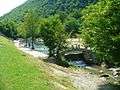 The Swimming Dam on the Bobas is a popular attraction
 The Kotor Varoš Red Cross building
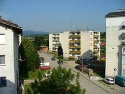
- The "Kocke" (Apartment Blocks) in the city
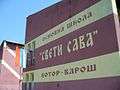 Elementary School "Sveti Sava", used to be called "Bratstvo i jedinstvo" ("Brotherhood and unity")
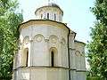 The Orthodox Christian church in Kotor Varoš
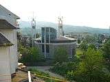 The Croatian catholic church, rebuilt
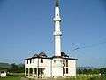 One of two mosques in Kotor Varos, this one is in the Kotor region
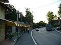 Caršija region of the city, shops litter the left side.
Features
The city also features a large monument to the local partisans who died for Yugoslavia during the fighting with the German and Ustaša forces during WW2.
Twin towns – Sister cities
Kotor Varoš is twinned with:
 Kranj, Slovenia
 Herceg Novi, Montenegro
 Kraljevo, Serbia
| Wikimedia Commons has media related to Kotor Varoš. |
Populated places in Bosnia and Herzegovina