Kotmale Dam
| Kotmale Dam | |
|---|---|
|
Upstream view of the Kotmale Dam. | |
 Location of Kotmale Dam in Sri Lanka | |
| Country | Sri Lanka |
| Location | Kotmale |
| Coordinates | 07°03′39″N 80°35′50″E / 7.06083°N 80.59722°ECoordinates: 07°03′39″N 80°35′50″E / 7.06083°N 80.59722°E |
| Purpose | Power |
| Status | Operational |
| Construction began | February 1979 |
| Opening date | August 1985 |
| Owner(s) | Mahaweli Authority |
| Dam and spillways | |
| Type of dam | Embankment dam |
| Impounds | Kotmale Oya |
| Height (foundation) | 87 m (285 ft) |
| Length | 600 m (1,969 ft) |
| Spillways | 3 |
| Reservoir | |
| Creates | Kotmale Reservoir |
| Power station | |
| Name | Kotmale Power Station |
| Coordinates | 07°07′41″N 80°34′42″E / 7.12806°N 80.57833°E |
| Operator(s) | Ceylon Electricity Board |
| Turbines | 3 × 67 MW |
| Installed capacity | 201 MW |
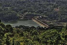
The Kotmale Dam is a large hydroelectric and irrigation dam in Kotmale, Sri Lanka. The dam generates power from three 67 MW turbines, totalling the installed capacity to 201 MW, making it the second largest hydroelectric power station in Sri Lanka. Construction on the dam began in August 1979 and was ceremonially completed in February 1985.[1]
See also
- List of power stations in Sri Lanka
- List of dams and reservoirs in Sri Lanka
- Upper Kotmale Dam
- Kadadora Vihara
References
| Wikimedia Commons has media related to Kotmale Dam. |
- ↑ "Kotmale Dam". Retrieved 21 April 2011.
This article is issued from Wikipedia - version of the 7/16/2016. The text is available under the Creative Commons Attribution/Share Alike but additional terms may apply for the media files.