Kothapally, Nizamabad
| Kothapally కొత్తపల్లి Kothapalle | |
|---|---|
| Village | |
|
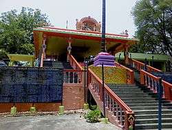
Shree Rajarajeshwara Swamy Temple | |
 Kothapally  Kothapally Location in Telangana, India | |
| Coordinates: 18°54′31.19″N 78°22′36.28″E / 18.9086639°N 78.3767444°ECoordinates: 18°54′31.19″N 78°22′36.28″E / 18.9086639°N 78.3767444°E | |
| Country | India |
| State | Telangana |
| District | Nizamabad |
| Talukas | Mupkal |
| Government | |
| • Member of Parliament | Kalvakuntla Kavitha |
| • Member of the Legislative Assembly | Prashanth Reddy Vemula |
| • Sarpanch | Rajavva Jaidi |
| Languages | |
| • Official | Telugu |
| Time zone | IST (UTC+5:30) |
| PIN | 503218 |
| Telephone code | 91-8463 |
| Vehicle registration | TS16 |
| Literacy | 55.39% |
| Sex ratio | 1163/1000 ♀/♂ |
| Lok Sabha constituency | Nizamabad |
| Legislative Assembly constituency | Balkonda |
Kothapally is a village in the Mupkal Mandal in the Nizamabad (Indhooru) District in the State of Telangana in India.[1][2][3]
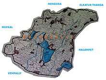
There are 709 households and 2,661 population is there in village as per 2011 Census, in that 1,230 are male and 1,431 are female.[4] The area of the village is about 8 km² including agricultural land. Godavari river is 4 km from the village. Mupkal, Nalloor, Mendora, Nagampet, Renjarla, Vannel-B and Vempalli are the names of nearby villages.
| Census | Households | Male | Female | Total | Literates |
|---|---|---|---|---|---|
| 2001 | 673 | 1382 | 1469 | 2851 | - |
| 2011 | 709(+05.35%) | 1230(-11.00%) | 1431(-02.59) | 2661(-06.66%) | 1,474(55.39%) |
History
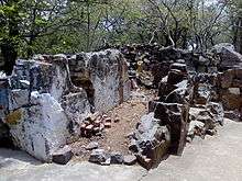
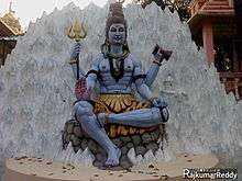
The area which village is located under Asmaka janapada(Assaka).[5] Of early Indian Vedic period, later it is under part of the Satavahana dynasty. Estimated at 500 years old, this village is home to the ancient temple of Lord Shiva. The exact year of the temple's construction or foundation is not known (it may be hundreds of years old) but the current structure was built in 1996. Enugula Veeraswami a public servant in British India from Madras mentioned about the area and villages like Balkonda, Mupkal, Dudgam which are near to the village in July of 1830 in his book named 'Kashi Yatra Charicham' about his pilgrimage to Varanasi. The age of the typical home in the village ranges from 100 – 200 years old.
Education
The village has a 55% literacy rate and there is one government school for primary education. Most of the students study at B.Tech. and obtain other degrees in the cities of Hyderabad and Nizamabad.Many of government employees are there in this village and they have their own association for their activities.This village is famous in the district for being good in sports like cricket,and mainly in kabaddi it won many prizes in state and national level tournaments, many tournaments are also conducting in village.
Transportation
The village is located 7 km from Balkonda. The towns located nearest to this village are Armoor (21 km), Nirmal (23 km), Metpally(40 km), Nizamabad (46 km), Adilabad(107 km) and Hyderabad (194 km). Shamshabad International Airport is the nearest airport located in Hyderabad and Nizamabad has the nearest railway station. The Bus service travelling from Armoor to Elkutoor APSRTC passes through the village twice a day. There are private automobiles that travel from Mupkal, a nearby village, with access to National Highway 7 (India)(New NH 44) and additional bus service between Hyderabad, Nizamabad, Adilabad, Nirmal and Armoor.
Culture

There are several Hindu temples are there in village mainly Sree Rajarajeshwara swamy Temple,Mahadeva Sannidhi,Hanuman Temple,Venkateshwara Sannidhi and Sree Nrusimha swamy Temples.Ugadi, Hanuman Jayanti, Mrigasira karthi, Ganesh Chaturthi, Dasara and Maha Shivaratri festivals are celebrated every year and Hindu and Islamic festivals are celebrated including village festivals. People belonging to different castes live peacefully together in the village. The main religions followed in the village are Hinduism 95%, Christianity 4% and Islam 1%. People belonging to different communities live together in friendship.Yearly in a specific season dramas are played for some days called Chindu Bhagavatham[6] since many generations.
Agriculture
Most of the people living in this village are farmers. The main crops cultivated are Rice, Turmeric (pasupu), Sweetcorn (mokka jonna), Pearl millet (sajja), Jowar(Jonna), Soya bean and Groundnut. The water resources for cultivation are bore wells, agricultural wells and canals. Lakshmi canal (sourced from the Sriram Sagar project reservoir) passes through this village. This village has its own large lake called Rajeshwara lake also have other small lakes like Rameshwara and Lingam lakes.
References
- ↑ G.P. Sarpanch
- ↑ Kothapalli
- ↑ " Villages in World
- ↑ 2011 census
- ↑ Raychaudhuri, Hemchandra (1972) Political History of Ancient India, University of Calcutta, mumbai, p.80
- ↑ Chindu Bhagavatham
External links
| Wikimedia Commons has media related to Kothapally, Nizamabad. |