Koszutka
| Koszutka | |
|---|---|
| Katowice District | |
|
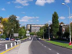
Sokolska street and building in Katowice-Koszutka | |
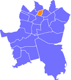 Location of Koszutka within Katowice | |
| Coordinates: 50°16′15.869″N 19°01′15.843″E / 50.27107472°N 19.02106750°ECoordinates: 50°16′15.869″N 19°01′15.843″E / 50.27107472°N 19.02106750°E | |
| Country |
|
| Voivodeship | Silesian |
| County/City | Katowice |
| Area | |
| • Total | 1.38 km2 (0.53 sq mi) |
| Population (2007) | |
| • Total | 12,431 |
| • Density | 9,000/km2 (23,000/sq mi) |
| Time zone | CET (UTC+1) |
| • Summer (DST) | CEST (UTC+2) |
| Area code(s) | (+48) 032 |
Koszutka (German: Kossutka) is a district of Katowice. It has an area of 1.38 km2 and in 2007 had 12,431 inhabitants.[1]
References
- ↑ Urząd Miasta Katowice. "Katowice - Studium uwarunkowań i kierunków zagospodarowania przestrzennego" (PDF) (in Polish). Retrieved 2011-06-16.
| Wikimedia Commons has media related to Koszutka. |
| I. Central-City |
| |
|---|---|---|
| II. North-City |
| |
| III. West-City | ||
| IV. East-City |
| |
| V. South-City |
| |
This article is issued from Wikipedia - version of the 5/13/2015. The text is available under the Creative Commons Attribution/Share Alike but additional terms may apply for the media files.