Kosovo field (region)
The Kosovo field (Serbian: Косово поље / Kosovo polje; Albanian: Fusha e Kosovës) is a large karst field (polje), a plain located in eastern part of Kosovo. It is mostly known for being the battlefield of the Battle of Kosovo (1389) between the Serbian and Ottoman armies, and many other battles.
Geography
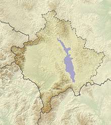
The large karst field is directed northwest–south. The plain stretches from Mitrovica southwards including Obilić, Kosovo Polje (which lies in the centre), Lipljan, and almost to Kaçanik. The region of Kosovo stretches roughly from Ferizaj (Uroševac) to Vučitrn.[1]
It is situated 500-600m above sea level.[2]
In the central part, to the west, is the Drenica valley.
History
In 1877, the Kosovo Vilayet was established by the Ottoman Empire.
During World War I the Serbian army retreated to the Kosovo plain by November 1915, then under attack from both sides, the army withdrew across the mountains into Albania.[3]
See also
References
- ↑ Dr. Dragan Ćukić (31 December 1971). Kosovo: Znamenitosti i lepote. Uros Maksimovic. pp. 9–. GGKEY:9UYXYK4U200.
- ↑ Salihu, Salih, Heinrich Grausgruber, and Peter Ruckenbauer. "Agronomic and quality performance of international winter wheat genotypes grown in Kosovo." Cereal Research Communications 34.2 (2006): 957-964.
Kosovo plain (Rrafshi i Kosovés), which lies 500-600 in above sea level, and is characterised by a longtime annual precipitation of 640 mm year", and a longtime annual mean temperature of 10°C.
- ↑ Ian V. Hogg (1995). Battles: A Concise Dictionary. Harcourt Brace. p. 87. ISBN 978-0-15-600397-1.
Coordinates: 42°35′00″N 21°07′00″E / 42.5833°N 21.1167°E