Komatipoort
| Komatipoort | |
|---|---|
|
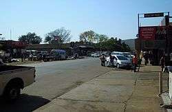
A street in Komatipoort | |
 Komatipoort  Komatipoort  Komatipoort
| |
| Coordinates: 25°26′S 31°57′E / 25.433°S 31.950°ECoordinates: 25°26′S 31°57′E / 25.433°S 31.950°E | |
| Country | South Africa |
| Province | Mpumalanga |
| District | Ehlanzeni |
| Municipality | Nkomazi |
| Established | 1874 |
| Area[1] | |
| • Total | 11.71 km2 (4.52 sq mi) |
| Population (2011)[1] | |
| • Total | 4,683 |
| • Density | 400/km2 (1,000/sq mi) |
| Racial makeup (2011)[1] | |
| • Black African | 61.0% |
| • Coloured | 1.2% |
| • Indian/Asian | 2.8% |
| • White | 34.4% |
| • Other | 0.6% |
| First languages (2011)[1] | |
| • Afrikaans | 30.8% |
| • Tsonga | 28.4% |
| • Swazi | 27.7% |
| • English | 7.6% |
| • Other | 5.5% |
| Postal code (street) | 1340 |
| PO box | 1340 |
| Area code | 013 |
Komatipoort is a town situated at the confluence of the Crocodile and Komati Rivers in Mpumalanga province, South Africa. The town is 8 km from the Crocodile Bridge Gate into the Kruger Park, and just 5 km from the Mozambique border and 65 km from the Swaziland border.
It is a small, quiet town within the Lowveld with some attractive tree lined streets. It is one of the hottest towns in South Africa where temperatures can reach almost 48°C (47.7 °C (117.9 °F) on 12 December 1944) in the height of summer, but also with a perfect winter climate around 24 °C (75 °F).
History
'Komati' takes its name from the Komati River whose original native Swazi name is Nkomazi, translated as "river of cows". It is where the Crocodile and Komati Rivers meet to flow through the 'Poort' (mountain pass) through the Lebombo Mountains into Mozambique.
In the 1890s Komatipoort of those days was a wild and uproarious construction camp for the railway being built from Lourenco Marques (modern Maputo). Conditions weren’t the best with the area gripped by a malaria epidemic; it was in the zone called 'fever country'.
Komatipoort was the last stop in the South African Republic (ZAR) Pretoria - Delagoa Bay Line constructed by the Netherlands-South African Railway Company (NZASM) with the first train crossing the border at Komatipoort from the ZAR to Portuguese East Africa on 1 July 1891 after the completion of the rail bridge over the Komati River.
Between 1900 and 1902 during the Anglo/Boer War, the town was used as a base by Major F Von Steinaecker and his group known as 'Steinaecker's Horse'. They were a bunch of mercenaries and bushwhackers and were recruited by the British in order to fight Boer guerrillas in the bushveld.
Near Komatipoort is the site where the former Mozambique's President Samora Machel died in a plane crash in the Lebombo mountain range, the natural barrier between South Africa and Mozambique. At the site of the accident stands the Samora Machel Monument.
The Nkomati Accord was signed in Komatipoort in 1984.
See also
References
- 1 2 3 4 "Main Place Komatipoort". Census 2011.
External links
Municipalities and communities of Ehlanzeni District Municipality, Mpumalanga | ||
|---|---|---|
District seat: Nelspruit | ||
| Mbombela | .svg.png) | |
| Nkomazi | ||
| Thaba Chweu | Blyde River Canyon • Bosoord • Graskop • Hendriksdal • Krugerspos • Leroro • Lydenburg • Maartenshoop • Mashishing • Mauchsberg • Matibidi • Moremela • Pilgrim's Rest • Sabie • Simile | |
| Umjindi | ||
| Bushbuckridge | ||