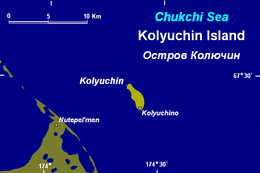
Kolyuchin Island
| Russian: Остров Колючин | |
|---|---|
 Kolyuchin Island | |
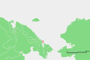 Location of Kolyuchin Island. | |
| Geography | |
| Coordinates | 67°28′N 174°37′W / 67.467°N 174.617°W |
| Length | 4.5 km (2.8 mi) |
| Width | 1.5 km (0.93 mi) |
| Administration | |
| Demographics | |
| Population | 0 |
Kolyuchin Island or Koliuchin Island (Russian: Остров Колючин) is a small island in the Chukchi Sea. It is not far from the coast, being only 11 km (6.8 mi) from the northern shore of the Chukotka Peninsula. Its latitude is 67° 28' N and its longitude 174° 37' E.
This island is 4.5 km (2.8 mi) in length and its maximum width is 1.5 km (0.93 mi). It is covered with tundra vegetation. There was a small Chukchi settlement on the southern end of the island called Kolyuchino but as of 1987, there was no village and very rare traces of former human presence such as separate logs and coals.[1]
On the nearby shore there is the settlement of Nutepel'men, located north of the Rypatynonel'gyn Lagoon and south of the Pyngopil'gyn Lagoon. Kolyuchinskaya Bay, further south, is named after Kolyuchin Island. Administratively this island and its surrounding area belongs to the Chukotka Autonomous Okrug of the Russian Federation.
History
In September 1933 Soviet ice-breaker Chelyuskin got crushed by pack ice near Kolyuchin Island. The passengers and crew were rescued by air in a dramatic and much publicised operation which made heroes of Captain Vladimir Voronin and expedition leader Otto Schmidt.
Photo Gallery
-

Kolyuchin Island: Walrus herds,
thick-billed murres and kittiwakes -
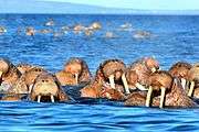
Kolyuchin Island: Walrus herds
near the island -

Kolyuchin Island: Bird rock
with thick-billed murres and kittiwakes -

Kolyuchin Island: Bird rock
with thick-billed murres and kittiwakes -

Kolyuchin Island:
Pelagic or Baird’s cormorants (Phalacrocorax pelagicus)
crossing the rocks -

Kolyuchin Island:
Abandoned polar station 2013 -

Kolyuchin Island:
Abandoned polar station 2014
See also
References
External links
- Armstrong, T., The Russians in the Arctic, London, 1958.
- Early Soviet Exploration:
- History of Russian Arctic Exploration:
- Pictures of animals in Kolyuchin Island:
- Prydatko-Dolin V. Kolyuchin Island Landscapes. My Arctic-in-Art, 2010 (Rus.):