Kolekole Beach Park
Kolekole Beach Park is a Hawaii county park on the island of Hawaii. The park is about 3 mi (4.8 km) downstream from ʻAkaka Falls, with an additional waterfall on the Kaʻahakini stream that drops directly from a small cliff into the main Kolekole Stream as it forms an estuary at the ocean. The stream passes through a rainforest containing several varieties of orchids.[1] The stream flows about 12.4 miles (20.0 km)[2] from an elevation of about 8,000 ft (2,400 m) on the eastern slope of Mauna Kea (at coordinates 19°48′42″N 155°21′52″W / 19.81167°N 155.36444°W) to sea level.[3]
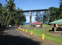
The Hawaii Belt Road (state route 19) passes over the park on a high bridge. The park is located in the South Hilo District at coordinates 19°52′53″N 155°7′17″W / 19.88139°N 155.12139°WCoordinates: 19°52′53″N 155°7′17″W / 19.88139°N 155.12139°W near the 14 mile marker.[4]
The name Kolekole means "raw or scarred" in the Hawaiian language.[5][6] Camping is allowed with a permit.[4]
The steel girder and truss bridge is over 500 ft (150 m) long. It provides the only major road between the town of Hilo and the Hāmākua district. It was originally built as a railroad bridge for sugarcane trains, but after the 1946 tsunami the railroad was abandoned and the bridge rebuilt for automobiles.[7] E. Claude Moore was the County Engineer who designed and executed the plan to use the old railroad bridges to span the ravines for the Hawaii belt road. Claude Moore was a World War II veteran of the U.S. Army Corps of Engineers. He attended Iowa State College and worked for the Iowa Highway Commission prior to World War II. After the stint as County Engineer, Claude Moore worked as a Civil Engineer for C Brewer Company. He designed many subdivisions on the island, and was a long time Scout leader and Director of what is now HFS Credit Union..
References
- ↑ "Rivers and Trails of Hawaii". Nationwide Rivers Inventory. National Park Service. Retrieved 2009-09-15.
- ↑ U.S. Geological Survey. National Hydrography Dataset high-resolution flowline data. The National Map Archived 2012-04-05 at WebCite, accessed April 28, 2011
- ↑ "Kolekole Stream". Geographic Names Information System. United States Geological Survey. 30 Sep 2003. Retrieved 2009-09-15.
- 1 2 "Kolekole Beach Park". County of Hawaii web site. Retrieved 2009-09-15.
- ↑ Lloyd J. Soehren (2010). "lookup of Kolekole Park ". in Hawaiian Place Names. Ulukau, the Hawaiian Electronic Library. Retrieved May 3, 2011.
- ↑ Mary Kawena Pukui, Samuel Hoyt Elbert and Esther T. Mookini (2004). "lookup of Kolekole ". in Place Names of Hawai'i. Ulukau, the Hawaiian Electronic Library, University of Hawaii Press. Retrieved May 3, 2011.
- ↑ Harold Hamada, David Fujiwara and Char Nakamoto. "Seismic Retrofit of Historical Kolekole Bridge". Structural engineering in the 21st century: proceedings of the 1999 Structures Congress. p. 268. ISBN 978-0-7844-0421-8.