Kohimarama
- For the Solomon Islands village, see Kohimarama, Guadalcanal.
| Kohimarama | |
|---|---|
 View of Kohimarama Beach | |
 Location in Auckland | |
| Basic information | |
| Local authority | Auckland Council |
| Population | 7092 (2013) |
| Surrounds | |
| North | Rangitoto Island, Tamaki Drive |
| Northeast | Hauraki Gulf, Browns Island |
| East | St Heliers |
| Southeast | Glen Innes, Glendowie |
| South | St Johns |
| Southwest | Meadowbank |
| West | Mission Bay, Orākei, Ōkahu Bay |
| Northwest | Waitematā Harbour, Devonport |
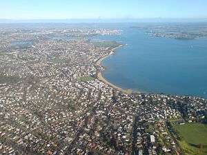
Kohimarama is a coastal residential Auckland suburb, located to the east of the city, with many homes having some of the best views across the Auckland Harbour. Kohimarama is situated between Mission Bay and St Heliers and has an accessible beach with a boardwalk and green recreational spaces located amongst residential areas. According to the 2013 census, Kohimarama has a population of 7092.[1] Local government of Kohimarama is the responsibility of the Orākei Local Board, which also includes the suburbs of Orākei, Mission Bay, St Heliers, Glendowie, St Johns, Meadowbank, Remuera and Ellerslie.[2]
History
Kohimarama used to be part of the Kohimarama Block, land acquired by European settlers from the indigenous Māori. This was a large area, from Orakei-Mission Bay to the Tamaki River and from the Waitematā Harbour to the outskirts of Panmure. Kohimarama’s former name was Waiparera, ‘duck water’, as the area was a breeding ground of the parera, the wild grey duck. This name was used by the Māori and by the European settlers, the Pākehā, until 1870. Arriving in Auckland in 1841, William Field Porter, was a month too late for the first Government auction, but became the first settler in today’s Kohimarama after the second auction. Then the area consisted of a lagoon, a raupo swamp and the Kohimarama beach, the longest beach in the Harbour. Porter sent men to clear, fence and drain the area. One of these men was Thomas Kemp, later to be a landowner of the neighbouring suburb, Mission Bay.[3]
The Kohimarama Wharf was built in 1912 on the Pipimea Head between Kohimarama and Mission Bay.[3][4] The first business in Kohimarama was a tearoom which catered to the people arriving at the newly built wharf. The access to the wharf was not easy; people had to walk around the rocks to and from the wharf which ultimately led to the building of the road now known as Tamaki Drive.[3]
From 1892 to 1919, Kohimarama was also known as the ‘Jockey Bay’, since the area was used as a training ground for race horses. In 1919, the stables were moved to Ronaki Road, Mission Bay, and the land in Kohimarama was leased to W.H. Madill, a dairy farmer.[3]
Today, Kohimarama is one of the quieter beaches along Tamaki Drive with some cosy cafes present along the beach front. The Kohimarama Yacht Club is located on Tamaki Drive. This club was set up in 1939 for young people and the construction of the club house at Gower’s Point, between the Kohimarama and Saint Heliers, was finished in 1957.[3]
Nature areas
Kohimarama has several nature reserves: Madills Farm Recreational Reserve, Mary Atkin Reserve, Kohimarama Beach Reserve, Sage Road Reserve and Speight Road Reserve.[5] Madills Farm Recreational Reserve used to be part of W.H. Madill's dairy farm in 1919. There are four playing fields on the northern half of the reserve.[3] Mary Atkin Reserve, named after an early missionary daughter, is a green open space where people can walk dogs.[6] Kohimarama Beach Reserve is mainly used for swimming. It is located east of the Kohimarama Yacht Club and many boat races are held there. It has boat ramps, bicycle stands and toilets.[7] Sage Road Reserve and Speight Road Reserve each function as an access way to Madills Farm Recreational Reserve.[8][9]
Education
Kohimarama is home to two primary and one secondary school: St Thomas' School, Kohimarama School, and Selwyn College, which has a student population of over 1,000. Conveniently located Catholic schools in close proximity include Sacred Heart College, Auckland in Glen Innes, St Peter's College in Grafton and Baradene College of the Sacred Heart in Remuera.
Sports
The football (soccer) club Eastern Suburbs AFC, which competes in the Lotto Sport Italia NRFL Division 1 and was crowned champion in 2011, is based in Kohimarama. Other sports clubs are the Kohimarama Tennis Club, the Kohimarama Yacht Club and Kohimarama Bowling Club which was formerly known as the Mission Bay Women's Bowling Club. The club changed its name in October 2013 after changing the rules about allowing men to join the club.[10]
Gallery
-

Kohimarama
-

Kohimarama beach and Tamaki Drive
-

Sunrise on 1 May 2009
-

Kohimarama
References
- ↑ "QuickStats About Kohimarama West & East", Statistics New Zealand. Retrieved 2014-03-27.
- ↑ "About the Orākei area". Auckland Council. 2013. Retrieved 2013-03-10.
- 1 2 3 4 5 6 Elizabeth T. Jackson (1976). Delving Into The Past of Auckland’s Eastern Suburbs: Section 4 Mission bay, Section 5 Kohimarama. Auckland, N.Z.
- ↑ "Looking South from Kohimarama...1931". Sir George Grey Special Collections, Auckland Libraries, Auckland Council. Retrieved 2013-10-17.
- ↑ "Find a Park". Auckland Council. 2013. Retrieved 2013-10-18.
- ↑ "Mary Atkin Reserve". Auckland Council. 2013. Retrieved 2013-10-18.
- ↑ "Kohimarama Beach Reserve". Auckland Council. 2013. Retrieved 2013-10-18.
- ↑ "Sage Road Reserve". Auckland Council. 2013. Retrieved 2013-10-18.
- ↑ "Speight Road Reserve". Auckland Council. 2013. Retrieved 2013-10-18.
- ↑ Mathew Dearnaley (15 October 2013). "' Hubby bowls up to cross gender divide'". The New Zealand Herald. Retrieved 2013-10-21.
- The Lively Capital, Auckland 1840-1865, Una Platts. Avon Fine Prints Limited New Zealand 1971.
External links
- Photographs of Kohimarama held in Auckland Libraries' heritage collections.
Coordinates: 36°51′33″S 174°50′45″E / 36.859074°S 174.845808°E